TopoQuest Logo
Do you find TopoQuest useful?
Help keep TopoQuest running and adding new maps/features by donating!
Bitcoin:  19c7KJd3qBynnjoSw5npx9KScwjBe4ifkT
Litecoin:  LXs6TkuXGGXo1vDsWCkWVdjQX94eUKd6ui
Home View Maps Find Maps Find Places Resources & Links


Stanfield, Oregon Topographic Map

USGS Map Title: Stanfield, OR
USGS Map MRC: 45119G2
DRG (GeoTIFF) Download: o45119g2.tif


Neighboring USGS Topographic Map Quads:


  Umatilla, OR  
45119H3
 

  Hat Rock, OR  
45119H2
 

  Juniper, OR  
45119H1
 

  Hermiston, OR  
45119G3
 

  Stanfield, OR  
45119G2
 

  Stanfield SE, OR  
45119G1
 

  Service Buttes, OR  
45119F3
 

  Echo, OR  
45119F2
 

  Nolin, OR  
45119F1


Map MRC Location:

N46°
W120°
N46°
W119°
H8 H7 H6 H5 H4 H3 H2 H1
G8 G7 G6 G5 G4 G3 G2 G1
F8 F7 F6 F5 F4 F3 F2 F1
E8 E7 E6 E5 E4 E3 E2 E1
D8 D7 D6 D5 D4 D3 D2 D1
C8 C7 C6 C5 C4 C3 C2 C1
B8 B7 B6 B5 B4 B3 B2 B1
A8 A7 A6 A5 A4 A3 A2 A1
N45°
W120°
N45°
W119°

Stanfield, OR USGS 1:24K Topographic Map Preview:
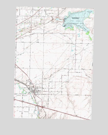
Stanfield, OR USGS Topographic Map
Click on map above to begin viewing in our Map Viewer.

This topographic map contains these locations and features:
Feature Name Type Latitude Longitude GNIS ID View Map
Bard ParkParkN45.7835°W119.2197°2091173View Map
Baumgardner CemeteryCemeteryN45.7622°W119.2346°1129810View Map
Charlotte Rauch ParkParkN45.7768°W119.2175°2091184View Map
City of StanfieldCivilN45.7849°W119.2191°2411967View Map
Coe Street ParkParkN45.7754°W119.2233°2091188View Map
Cold Springs CanyonValleyN45.8676°W119.1408°1119122View Map
Cold Springs DamDamN45.8607°W119.1722°1159110View Map
Cold Springs National Wildlife RefugeParkN45.8605°W119.1495°1119124View Map
Cold Springs ReservoirReservoirN45.8618°W119.1512°1119125View Map
Columbia Grange HallBuildingN45.8610°W119.2333°1639282View Map
Despain GulchValleyN45.8571°W119.1453°1119883View Map
Echo Wastewater Treatment PlantLocaleN45.7568°W119.2101°2697038View Map
Foster CemeteryCemeteryN45.7671°W119.2125°1120906View Map
Fosters (historical)LocaleN45.7704°W119.2158°1167768View Map
Fourmile GapGapN45.8107°W119.1553°1120923View Map
Furnish DitchCanalN45.7771°W119.1817°1158253View Map
Hermiston Fire and Emergency Services Station 2BuildingN45.8642°W119.2252°2576583View Map
L CanalCanalN45.8637°W119.2095°1129796View Map
Lenz LateralCanalN45.8312°W119.1375°1123044View Map
Meadowville Post Office (historical)Post OfficeN45.7790°W119.2247°1164509View Map
Moorhouse Post Office (historical)Post OfficeN45.8221°W119.1539°1165662View Map
Pleasant View CemeteryCemeteryN45.7942°W119.2040°1125488View Map
South Point Boat LaunchLocaleN45.8541°W119.1471°2700193View Map
Stage GulchValleyN45.8051°W119.1483°1127516View Map
StanfieldPopulated PlaceN45.7804°W119.2172°1136780View Map
Stanfield Branch Furnish DitchCanalN45.8024°W119.1822°1127526View Map
Stanfield City HallBuildingN45.7799°W119.2174°2700400View Map
Stanfield DrainCanalN45.7887°W119.1803°1129797View Map
Stanfield Elementary SchoolSchoolN45.7903°W119.2267°2490578View Map
Stanfield Fire DepartmentBuildingN45.7808°W119.2196°2576535View Map
Stanfield Heights ParkParkN45.7887°W119.2233°2091227View Map
Stanfield JunctionLocaleN45.7626°W119.2036°1136781View Map
Stanfield Junior High School (historical)SchoolN45.7812°W119.2131°1167897View Map
Stanfield Municipal CourtBuildingN45.7799°W119.2174°2700399View Map
Stanfield Police DepartmentBuildingN45.7811°W119.2181°2737782View Map
Stanfield Post OfficePost OfficeN45.7802°W119.2171°1165983View Map
Stanfield Public LibraryBuildingN45.7808°W119.2186°2700401View Map
Stanfield Public Works DepartmentBuildingN45.7823°W119.2241°2700398View Map
Stanfield Secondary SchoolSchoolN45.7900°W119.2242°1167896View Map
Stanfield Wastewater Treatment FacilityLocaleN45.7823°W119.2241°2697113View Map
U S B Line CanalCanalN45.7999°W119.2470°1129811View Map
Walchli DamDamN45.8615°W119.1861°1133702View Map
Walchli ReservoirReservoirN45.8617°W119.1831°1133703View Map
West Stanfield School (historical)SchoolN45.7836°W119.2222°1128898View Map

Note: Coordinates in the location and feature list above are referenced to NAD83 datum.


Copyright (C) 2008-2024 Ryan Niemi / Sunset Dynamics ... All Rights Reserved