TopoQuest Logo
Do you find TopoQuest useful?
Help keep TopoQuest running and adding new maps/features by donating!
Bitcoin:  19c7KJd3qBynnjoSw5npx9KScwjBe4ifkT
Litecoin:  LXs6TkuXGGXo1vDsWCkWVdjQX94eUKd6ui
Home View Maps Find Maps Find Places Resources & Links


Umatilla, Oregon Topographic Map

USGS Map Title: Umatilla, OR
USGS Map MRC: 45119H3
DRG (GeoTIFF) Download: o45119h3.tif


Neighboring USGS Topographic Map Quads:


  Prior Ranch, WA  
46119A4
 

  Taylor Canyon, WA  
46119A3
 

  Johnson Butte, WA  
46119A2
 

  Irrigon, OR  
45119H4
 

  Umatilla, OR  
45119H3
 

  Hat Rock, OR  
45119H2
 

  Ordnance, OR  
45119G4
 

  Hermiston, OR  
45119G3
 

  Stanfield, OR  
45119G2


Map MRC Location:

N46°
W120°
N46°
W119°
H8 H7 H6 H5 H4 H3 H2 H1
G8 G7 G6 G5 G4 G3 G2 G1
F8 F7 F6 F5 F4 F3 F2 F1
E8 E7 E6 E5 E4 E3 E2 E1
D8 D7 D6 D5 D4 D3 D2 D1
C8 C7 C6 C5 C4 C3 C2 C1
B8 B7 B6 B5 B4 B3 B2 B1
A8 A7 A6 A5 A4 A3 A2 A1
N45°
W120°
N45°
W119°

Umatilla, OR USGS 1:24K Topographic Map Preview:
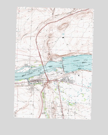
Umatilla, OR USGS Topographic Map
Click on map above to begin viewing in our Map Viewer.

This topographic map contains these locations and features:
Feature Name Type Latitude Longitude GNIS ID View Map
Benton County Fire District 6BuildingN45.9359°W119.3559°2643405View Map
Brownell DitchCanalN45.9207°W119.3117°1118131View Map
CharlestownPopulated PlaceN45.8887°W119.2975°1136141View Map
City of UmatillaCivilN45.9240°W119.2602°2412127View Map
Clara Brownell Middle SchoolSchoolN45.9170°W119.3380°1167889View Map
Coyote CouleeValleyN45.8915°W119.3536°1119454View Map
Gravel Pit Spur (historical)LocaleN45.9112°W119.3281°1167770View Map
Hermiston JunctionLocaleN45.9179°W119.3056°1121773View Map
KLWJ-AMTowerN45.8799°W119.3447°1131250View Map
M CanalCanalN45.8776°W119.2617°1123651View Map
McNaryPopulated PlaceN45.9193°W119.2892°1136529View Map
McNary BeachBeachN45.9290°W119.2817°1129673View Map
McNary Beach Recreation AreaParkN45.9304°W119.2724°1167894View Map
McNary Dam / Oregon Boat RampLocaleN45.9269°W119.2917°2700191View Map
McNary Dam Fish LadderLocaleN45.9304°W119.2967°1160554View Map
McNary Dam Fish Viewing StationLocaleN45.9287°W119.2933°1160553View Map
McNary Golf CourseLocaleN45.9215°W119.2886°1163741View Map
McNary Heights Elementary SchoolSchoolN45.9193°W119.2953°1161856View Map
McNary Lock and DamDamN45.9355°W119.2979°1506586View Map
McNary Post OfficePost OfficeN45.9193°W119.2892°1165611View Map
McNary Range ChannelChannelN45.9360°W119.3192°1156777View Map
North McNaryPopulated PlaceN45.9426°W119.3086°1511189View Map
Nugent Park Boat RampLocaleN45.9145°W119.3486°2700188View Map
O CanalCanalN45.9090°W119.2789°1124873View Map
O PipeCanalN45.8985°W119.2533°1124874View Map
OA LateralCanalN45.9007°W119.2742°1124875View Map
OB LateralCanalN45.9099°W119.2886°1124876View Map
Pioneer Memorial CemeteryCemeteryN45.9162°W119.3497°1167893View Map
Pioneer Memorial CemeteryCemeteryN45.9166°W119.3495°1129674View Map
PlymouthPopulated PlaceN45.9346°W119.3503°1507501View Map
Plymouth Elementary SchoolSchoolN45.9337°W119.3578°1515533View Map
Plymouth ParkParkN45.9315°W119.3495°1533423View Map
Plymouth Post OfficePost OfficeN45.9366°W119.3517°2781601View Map
Power CityPopulated PlaceN45.9118°W119.3039°1136652View Map
R CanalCanalN45.8762°W119.3120°1125758View Map
Race City United States AmericaLocaleN45.8912°W119.3006°2699730View Map
S CanalCanalN45.8926°W119.2645°1126396View Map
Sharps CornerLocaleN45.9179°W119.3228°1136746View Map
Sillusi ButteSummitN45.9482°W119.3167°1508334View Map
Spawning ChannelChannelN45.9282°W119.3045°1127374View Map
Straub CanyonValleyN45.9885°W119.3145°1508768View Map
Sunset Hills CemeteryCemeteryN45.9076°W119.3519°1124658View Map
Taylor CanyonValleyN45.9971°W119.2814°1508921View Map
Three Mile Falls PoolReservoirN45.8821°W119.3242°1133690View Map
Threemile Falls Diversion WorksDamN45.8825°W119.3260°1128074View Map
Two Rivers Correctional InstitutionBuildingN45.9270°W119.2609°2722755View Map
UmatillaPopulated PlaceN45.9174°W119.3425°1128399View Map
Umatilla BridgeBridgeN45.9310°W119.3284°1159376View Map
Umatilla ButteSummitN45.8862°W119.3095°1128400View Map
Umatilla City HallBuildingN45.9170°W119.3444°2700403View Map
Umatilla ClinicHospitalN45.9172°W119.3267°2770122View Map
Umatilla DrainCanalN45.8999°W119.3006°1128401View Map
Umatilla High SchoolSchoolN45.9162°W119.3368°1167892View Map
Umatilla Junction (historical)LocaleN45.9196°W119.3372°1167836View Map
Umatilla Marina ParkParkN45.9251°W119.3311°1167895View Map
Umatilla Marina RV ParkHarborN45.9256°W119.3321°2699005View Map
Umatilla Marina RV Park Boat RampLocaleN45.9257°W119.3306°2698980View Map
Umatilla Municipal CourtBuildingN45.9170°W119.3444°2700402View Map
Umatilla Police DepartmentBuildingN45.9163°W119.3482°2737731View Map
Umatilla Post OfficePost OfficeN45.9179°W119.3257°1166080View Map
Umatilla Public LibraryBuildingN45.9170°W119.3444°2700404View Map
Umatilla Rapids (historical)RapidsN45.9382°W119.3025°1514759View Map
Umatilla RiverStreamN45.9193°W119.3556°1157874View Map
Umatilla Rural Fire Protection District HeadquartersBuildingN45.9173°W119.2883°2576989View Map
Umatilla Rural Fire Protection District Station 2BuildingN45.9179°W119.3420°2576991View Map
Umatilla Toll Bridge Toll Plaza (historical)BuildingN45.9249°W119.3253°1160555View Map
Umatilla Wastewater Treatment FacilityLocaleN45.9215°W119.3395°2697096View Map
Wolfe FeedlotLocaleN45.8850°W119.2700°2576420View Map

Note: Coordinates in the location and feature list above are referenced to NAD83 datum.


Copyright (C) 2008-2024 Ryan Niemi / Sunset Dynamics ... All Rights Reserved