TopoQuest Logo
Do you find TopoQuest useful?
Help keep TopoQuest running and adding new maps/features by donating!
Bitcoin:  19c7KJd3qBynnjoSw5npx9KScwjBe4ifkT
Litecoin:  LXs6TkuXGGXo1vDsWCkWVdjQX94eUKd6ui
Home View Maps Find Maps Find Places Resources & Links


Stanley, Missouri Topographic Map

USGS Map Title: Stanley, MO
USGS Map MRC: 36089C6
DRG (GeoTIFF) Download: o36089c6.tif


Neighboring USGS Topographic Map Quads:


  Boekerton, MO  
36089D7
 

  Portageville, MO  
36089D6
 

  Point Pleasant, MO  
36089D5
 

  Wardell, MO  
36089C7
 

  Stanley, MO  
36089C6
 

  Mooring, TN  
36089C5
 

  Hayti Heights, MO  
36089B7
 

  Caruthersville, MO  
36089B6
 

  Tennemo, TN  
36089B5


Map MRC Location:

N37°
W90°
N37°
W89°
H8 H7 H6 H5 H4 H3 H2 H1
G8 G7 G6 G5 G4 G3 G2 G1
F8 F7 F6 F5 F4 F3 F2 F1
E8 E7 E6 E5 E4 E3 E2 E1
D8 D7 D6 D5 D4 D3 D2 D1
C8 C7 C6 C5 C4 C3 C2 C1
B8 B7 B6 B5 B4 B3 B2 B1
A8 A7 A6 A5 A4 A3 A2 A1
N36°
W90°
N36°
W89°

Stanley, MO USGS 1:24K Topographic Map Preview:
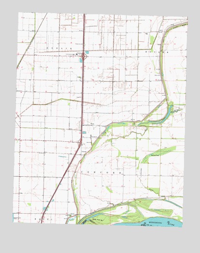
Stanley, MO USGS Topographic Map
Click on map above to begin viewing in our Map Viewer.

This topographic map contains these locations and features:
Feature Name Type Latitude Longitude GNIS ID View Map
Apostolic ChurchChurchN36.3659°W89.6462°713354View Map
Averill CemeteryCemeteryN36.2989°W89.6937°713501View Map
Bethlehem ChurchChurchN36.3281°W89.7498°714091View Map
Big Lake (historical)LakeN36.2803°W89.6995°739558View Map
Black Island Church (historical)ChurchN36.2556°W89.7045°746791View Map
Black Island School (historical)SchoolN36.2798°W89.6690°746786View Map
BrentPopulated PlaceN36.3642°W89.7356°739562View Map
Brinkerhoff (historical)Populated PlaceN36.3495°W89.7392°739561View Map
Bush Church (historical)ChurchN36.3506°W89.6459°746788View Map
Clover Hill ChurchChurchN36.3637°W89.7373°716013View Map
ConcordPopulated PlaceN36.2934°W89.7009°716168View Map
Concord Church (historical)ChurchN36.2984°W89.7279°746768View Map
Concord SchoolSchoolN36.2990°W89.7279°746793View Map
Concord School (historical)SchoolN36.2987°W89.7004°746767View Map
Consolidated School District 4SchoolN36.2973°W89.7004°746792View Map
Darnell School (historical)SchoolN36.3423°W89.6695°746794View Map
Ditch Number 23CanalN36.2920°W89.7356°755081View Map
Ditch Number 24CanalN36.2676°W89.7431°755083View Map
Ditch Number 25CanalN36.2776°W89.7423°755085View Map
Dry Bayou (historical)StreamN36.2970°W89.6934°739560View Map
Dry Bayou CemeteryCemeteryN36.3028°W89.6942°746787View Map
Dry Bayou ChurchChurchN36.3023°W89.6940°717061View Map
Dry Bayou ChurchChurchN36.3090°W89.6831°717062View Map
Dry Bayou School (historical)SchoolN36.3098°W89.6823°746769View Map
Fisher Church (historical)ChurchN36.3545°W89.7023°746789View Map
Fisher School (historical)SchoolN36.3551°W89.7023°746790View Map
GayosoPopulated PlaceN36.2562°W89.7051°739559View Map
Glass Memorial ChurchChurchN36.2556°W89.7070°718490View Map
Mount Carmel ChurchChurchN36.2915°W89.7279°730156View Map
Mud BayouStreamN36.3178°W89.6362°723007View Map
North Pemiscot Junior High SchoolSchoolN36.3509°W89.7062°723485View Map
North Pemiscot SchoolSchoolN36.3506°W89.7084°723486View Map
Pleasant Grove ChurchChurchN36.3570°W89.7020°724484View Map
Robinson BayouStreamN36.2662°W89.6404°725412View Map
Robinson LakeLakeN36.2926°W89.6498°725419View Map
Ross CemeteryCemeteryN36.3642°W89.6540°725575View Map
Sandy Hook BarBarN36.2526°W89.6831°726043View Map
StancilPopulated PlaceN36.3515°W89.6454°730283View Map
Stancil BayouGutN36.3706°W89.6256°730221View Map
Stancil CemeteryCemeteryN36.3395°W89.6484°730222View Map
StanleyPopulated PlaceN36.3373°W89.7012°727004View Map
Stanley ChurchChurchN36.3253°W89.7017°730224View Map
Stanley School (historical)SchoolN36.3265°W89.7020°746770View Map
Township of ConcordCivilN36.2823°W89.6729°767141View Map
Township of GodairCivilN36.3692°W89.7175°767143View Map
Wolf BayouStreamN36.2567°W89.6923°729026View Map

Note: Coordinates in the location and feature list above are referenced to NAD83 datum.


Copyright (C) 2008-2024 Ryan Niemi / Sunset Dynamics ... All Rights Reserved