TopoQuest Logo
Do you find TopoQuest useful?
Help keep TopoQuest running and adding new maps/features by donating!
Bitcoin:  19c7KJd3qBynnjoSw5npx9KScwjBe4ifkT
Litecoin:  LXs6TkuXGGXo1vDsWCkWVdjQX94eUKd6ui
Home View Maps Find Maps Find Places Resources & Links


Tennemo, Tennessee Topographic Map

USGS Map Title: Tennemo, TN
USGS Map MRC: 36089B5
DRG (GeoTIFF) Download: o36089b5.tif


Neighboring USGS Topographic Map Quads:


  Stanley, MO  
36089C6
 

  Mooring, TN  
36089C5
 

  Ridgely, TN  
36089C4
 

  Caruthersville, MO  
36089B6
 

  Tennemo, TN  
36089B5
 

  Miston, TN  
36089B4
 

  Cottonwood Point, MO  
36089A6
 

  Caruthersville SE, TN  
36089A5
 

  Dyersburg, TN  
36089A4


Map MRC Location:

N37°
W90°
N37°
W89°
H8 H7 H6 H5 H4 H3 H2 H1
G8 G7 G6 G5 G4 G3 G2 G1
F8 F7 F6 F5 F4 F3 F2 F1
E8 E7 E6 E5 E4 E3 E2 E1
D8 D7 D6 D5 D4 D3 D2 D1
C8 C7 C6 C5 C4 C3 C2 C1
B8 B7 B6 B5 B4 B3 B2 B1
A8 A7 A6 A5 A4 A3 A2 A1
N36°
W90°
N36°
W89°

Tennemo, TN USGS 1:24K Topographic Map Preview:
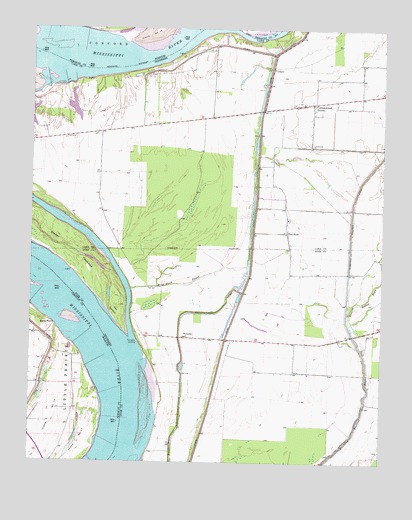
Tennemo, TN USGS Topographic Map
Click on map above to begin viewing in our Map Viewer.

This topographic map contains these locations and features:
Feature Name Type Latitude Longitude GNIS ID View Map
Bells PointCapeN36.1645°W89.6162°713931View Map
Bells Point LandingLocaleN36.1634°W89.6209°741811View Map
Blaker TowheadIslandN36.1876°W89.6154°1305283View Map
Blaker Towhead RevetmentLeveeN36.1801°W89.6109°1309776View Map
Blue Bank BayouStreamN36.1751°W89.5895°1277744View Map
Chute School (historical)SchoolN36.1542°W89.6201°741812View Map
Commissioner District 4CivilN36.2271°W89.5593°2464056View Map
Cotonwood School (historical)SchoolN36.2159°W89.5254°1319167View Map
Cottonwood ChurchChurchN36.2165°W89.5254°1306131View Map
Cottonwood GrovePopulated PlaceN36.2287°W89.5251°1306132View Map
Cottonwood Grove Baptist ChurchChurchN36.2290°W89.5301°1319166View Map
Dike Number FiveLeveeN36.2334°W89.5417°1311420View Map
District 18 (historical)CivilN36.1612°W89.5334°1310270View Map
Fritz LandingLocaleN36.2362°W89.6012°1319173View Map
Fritz RevetmentLeveeN36.2395°W89.5806°1311395View Map
Gore TowheadFlatN36.1684°W89.5951°1285709View Map
Gore Towhead BarBarN36.1417°W89.5834°1643399View Map
Grassy Lake (historical)LakeN36.2431°W89.5167°1311398View Map
Island Number 16AreaN36.1309°W89.6201°755230View Map
Linwood BendBendN36.1376°W89.5862°1309820View Map
Linwood LandingLocaleN36.1323°W89.5812°1309822View Map
Mud Lake (historical)LakeN36.2448°W89.5290°1311419View Map
Owl HootPopulated PlaceN36.1912°W89.5340°1315665View Map
Pecks Mill School (historical)SchoolN36.2265°W89.5956°1319199View Map
Reelfoot LandingLocaleN36.2470°W89.5495°1319204View Map
Running Reelfoot DitchCanalN36.1990°W89.5104°1300251View Map
Seventy-nine Church (historical)ChurchN36.2220°W89.5804°1319208View Map
Seventy-nine School (historical)SchoolN36.2220°W89.5809°1319209View Map
TennemoPopulated PlaceN36.1609°W89.5690°1314388View Map
Tennemo Bar (historical)BarN36.1640°W89.6001°1643417View Map
Tennemo LandingLocaleN36.1595°W89.5865°1314389View Map
Tom Folkes School (historical)SchoolN36.1865°W89.5326°1309853View Map

Note: Coordinates in the location and feature list above are referenced to NAD83 datum.


Copyright (C) 2008-2025 Ryan Niemi / Sunset Dynamics ... All Rights Reserved