TopoQuest Logo
Do you find TopoQuest useful?
Help keep TopoQuest running and adding new maps/features by donating!
Bitcoin:  19c7KJd3qBynnjoSw5npx9KScwjBe4ifkT
Litecoin:  LXs6TkuXGGXo1vDsWCkWVdjQX94eUKd6ui
Home View Maps Find Maps Find Places Resources & Links


Caruthersville, Missouri Topographic Map

USGS Map Title: Caruthersville, MO
USGS Map MRC: 36089B6
DRG (GeoTIFF) Download: o36089b6.tif


Neighboring USGS Topographic Map Quads:


  Wardell, MO  
36089C7
 

  Stanley, MO  
36089C6
 

  Mooring, TN  
36089C5
 

  Hayti Heights, MO  
36089B7
 

  Caruthersville, MO  
36089B6
 

  Tennemo, TN  
36089B5
 

  Steele, MO  
36089A7
 

  Cottonwood Point, MO  
36089A6
 

  Caruthersville SE, TN  
36089A5


Map MRC Location:

N37°
W90°
N37°
W89°
H8 H7 H6 H5 H4 H3 H2 H1
G8 G7 G6 G5 G4 G3 G2 G1
F8 F7 F6 F5 F4 F3 F2 F1
E8 E7 E6 E5 E4 E3 E2 E1
D8 D7 D6 D5 D4 D3 D2 D1
C8 C7 C6 C5 C4 C3 C2 C1
B8 B7 B6 B5 B4 B3 B2 B1
A8 A7 A6 A5 A4 A3 A2 A1
N36°
W90°
N36°
W89°

Caruthersville, MO USGS 1:24K Topographic Map Preview:
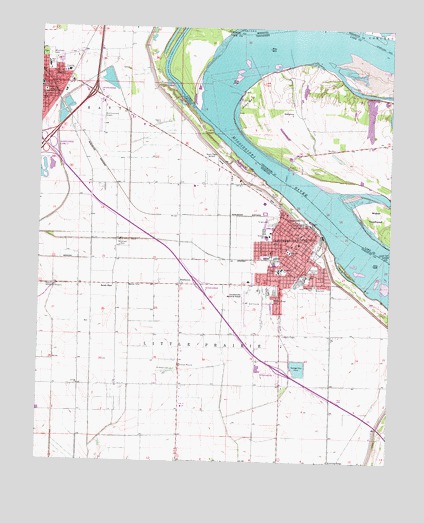
Caruthersville, MO USGS Topographic Map
Click on map above to begin viewing in our Map Viewer.

This topographic map contains these locations and features:
Feature Name Type Latitude Longitude GNIS ID View Map
CarlstonPopulated PlaceN36.2217°W89.7373°740028View Map
Carlston SchoolSchoolN36.2048°W89.7320°741814View Map
Carlston School (historical)SchoolN36.2048°W89.7179°741815View Map
CaruthersvillePopulated PlaceN36.1931°W89.6556°715460View Map
Caruthersville Fire DepartmentBuildingN36.1831°W89.6625°2621172View Map
Caruthersville Memorial AirportAirportN36.1734°W89.6754°758628View Map
Caruthersville Police Department and Public Safety CenterBuildingN36.1837°W89.6622°2752485View Map
Caruthersville Police Department SubstationBuildingN36.1761°W89.6483°2752132View Map
Caruthersville Post OfficePost OfficeN36.1932°W89.6560°2779478View Map
Chapel Church (historical)ChurchN36.1759°W89.7217°741817View Map
Chapel School (historical)SchoolN36.1756°W89.7237°741816View Map
Chute School (historical)SchoolN36.1476°W89.6812°741820View Map
City of CaruthersvilleCivilN36.1815°W89.6664°2393761View Map
City of HaytiCivilN36.2323°W89.7474°2394336View Map
CunninghamPopulated PlaceN36.1970°W89.7004°737969View Map
Dowd School (historical)SchoolN36.2481°W89.7140°741813View Map
Eastside ParkParkN36.1806°W89.6520°717363View Map
Flag Lakes School (historical)SchoolN36.2009°W89.7448°746719View Map
Golden Light Church (historical)ChurchN36.1476°W89.6806°741821View Map
HathawayPopulated PlaceN36.2262°W89.6598°1315204View Map
Hathaway Church (historical)ChurchN36.2267°W89.6601°1319176View Map
Hathaway Landing Revetment (historical)LeveeN36.2403°W89.6509°1311402View Map
Hathaway School (historical)SchoolN36.2273°W89.6601°1319178View Map
Hathway DikesLeveeN36.2306°W89.6326°1311401View Map
Hathway Landing (historical)LocaleN36.2409°W89.6529°1319177View Map
HaytiPopulated PlaceN36.2337°W89.7495°719268View Map
Hayti Fire DepartmentBuildingN36.2334°W89.7458°2620999View Map
Hayti Police DepartmentBuildingN36.2317°W89.7485°2752338View Map
Hayti Post OfficePost OfficeN36.2334°W89.7444°2759146View Map
Huffman CemeteryCemeteryN36.1515°W89.7020°719960View Map
Indian MoundPopulated PlaceN36.1512°W89.6990°737970View Map
Island Number FifteenFlatN36.2281°W89.6759°1289092View Map
Island Number Fifteen DikesLeveeN36.2423°W89.6617°1311404View Map
Island Number Fifteen RevetmentLeveeN36.2356°W89.6729°1311405View Map
KCRV-AM (Caruthersville)TowerN36.2140°W89.6904°759240View Map
KLOW-FM (Caruthersville)TowerN36.2140°W89.6904°759137View Map
Little Prairie BendBendN36.2378°W89.6820°1311413View Map
Little Prairie CemeteryCemeteryN36.1748°W89.6681°721301View Map
Loving ChurchChurchN36.1470°W89.7356°721624View Map
Magnolia CemeteryCemeteryN36.1759°W89.6517°722514View Map
Maple CemeteryCemeteryN36.1742°W89.6656°721816View Map
Marvin ChapelChurchN36.1756°W89.7234°721944View Map
Mavity LandingLocaleN36.2303°W89.6256°1319194View Map
Mid Continent AirportAirportN36.2281°W89.7280°758713View Map
MitchellsLocaleN36.1470°W89.7220°740077View Map
Morgan Ridge CemeteryCemeteryN36.1717°W89.6662°722619View Map
MoundsLocaleN36.1476°W89.6870°740322View Map
Mounds School (historical)SchoolN36.1467°W89.7262°741818View Map
Mounds School (historical)SchoolN36.1520°W89.7012°741819View Map
Mount Olive Church (historical)ChurchN36.2048°W89.7156°746720View Map
Patterson CemeteryCemeteryN36.1884°W89.7201°724082View Map
Pemiscot County Memorial HospitalHospitalN36.2374°W89.7406°2655042View Map
Pemiscot County Sheriff's OfficeBuildingN36.1886°W89.6582°2752298View Map
Powell LandingLocaleN36.2095°W89.6617°1315773View Map
Powells FerryCrossingN36.2060°W89.6626°1311422View Map
Rice CemeteryCemeteryN36.1756°W89.6512°725243View Map
Robinson Bayou RevetmentLeveeN36.2403°W89.6904°1311423View Map
Rood SchoolSchoolN36.1856°W89.6606°725549View Map
Sacred Heart ChurchChurchN36.1895°W89.6565°730287View Map
Sacred Heart SchoolSchoolN36.1895°W89.6554°725705View Map
SchultPopulated PlaceN36.2053°W89.7201°737968View Map
Southside SchoolSchoolN36.1806°W89.6631°726812View Map
Speers CemeteryCemeteryN36.2226°W89.7067°726842View Map
StubtownPopulated PlaceN36.1762°W89.6992°727196View Map
Township of Little PrairieCivilN36.1549°W89.7028°767146View Map
Westside SchoolSchoolN36.1901°W89.6687°728656View Map
Woodlawn CemeteryCemeteryN36.2420°W89.7470°729108View Map

Note: Coordinates in the location and feature list above are referenced to NAD83 datum.


Copyright (C) 2008-2024 Ryan Niemi / Sunset Dynamics ... All Rights Reserved