TopoQuest Logo
Do you find TopoQuest useful?
Help keep TopoQuest running and adding new maps/features by donating!
Bitcoin:  19c7KJd3qBynnjoSw5npx9KScwjBe4ifkT
Litecoin:  LXs6TkuXGGXo1vDsWCkWVdjQX94eUKd6ui
Home View Maps Find Maps Find Places Resources & Links


Hays Spring, Texas Topographic Map

USGS Map Title: Hays Spring, TX
USGS Map MRC: 31095D5
DRG (GeoTIFF) Download: o31095d5.tif


Neighboring USGS Topographic Map Quads:


  Indian Lake, TX  
31095E6
 

  Elkhart Creek, TX  
31095E5
 

  Percilla, TX  
31095E4
 

  Stanmire Lake, TX  
31095D6
 

  Hays Spring, TX  
31095D5
 

  Grapeland, TX  
31095D4
 

  Halls Bluff, TX  
31095C6
 

  Porter Springs, TX  
31095C5
 

  Crockett, TX  
31095C4


Map MRC Location:

N32°
W96°
N32°
W95°
H8 H7 H6 H5 H4 H3 H2 H1
G8 G7 G6 G5 G4 G3 G2 G1
F8 F7 F6 F5 F4 F3 F2 F1
E8 E7 E6 E5 E4 E3 E2 E1
D8 D7 D6 D5 D4 D3 D2 D1
C8 C7 C6 C5 C4 C3 C2 C1
B8 B7 B6 B5 B4 B3 B2 B1
A8 A7 A6 A5 A4 A3 A2 A1
N31°
W96°
N31°
W95°

Hays Spring, TX USGS 1:24K Topographic Map Preview:
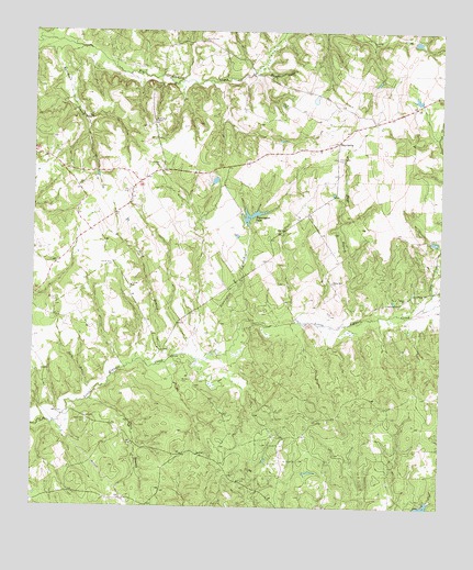
Hays Spring, TX USGS Topographic Map
Click on map above to begin viewing in our Map Viewer.

This topographic map contains these locations and features:
Feature Name Type Latitude Longitude GNIS ID View Map
Bill Huff DamDamN31.4835°W95.5386°1860701View Map
Bill Huff LakeReservoirN31.4825°W95.5391°1860702View Map
Bird SchoolSchoolN31.4257°W95.5811°1377399View Map
Caney CreekStreamN31.4280°W95.5058°1353738View Map
Caney Creek SpringsSpringN31.4585°W95.5086°1998532View Map
Clark BranchStreamN31.4032°W95.6075°1354557View Map
Clark Cotton GinBuildingN31.4013°W95.6036°1377397View Map
Coonskin CrossingCrossingN31.4380°W95.5611°1377408View Map
Corinth ChurchChurchN31.4332°W95.5950°1354993View Map
Dalys ChurchChurchN31.4593°W95.6113°1355560View Map
Dan Pennington DamDamN31.4302°W95.5469°1860699View Map
Farm LakeReservoirN31.4327°W95.5469°1860700View Map
Ferrell Women GravesCemeteryN31.4535°W95.5697°1377392View Map
Halls Field CemeteryCemeteryN31.3974°W95.6083°1358681View Map
Hays BranchStreamN31.4232°W95.5305°1358943View Map
Hays Branch SpringsSpringN31.4585°W95.5419°1998534View Map
Hays SpringPopulated PlaceN31.4707°W95.5319°1379911View Map
Hays Spring CemeteryCemeteryN31.4668°W95.5322°1358947View Map
Houston County DamDamN31.4068°W95.6052°1860697View Map
Houston County LakeLakeN31.4144°W95.5769°1377393View Map
Houston County LakeReservoirN31.4068°W95.6052°1860698View Map
Johua Hall Grain MillBuildingN31.4027°W95.6094°1377396View Map
Johua Hall SawmillBuildingN31.4027°W95.6094°1377395View Map
Ladyville SchoolSchoolN31.4455°W95.5744°1377403View Map
Llynwood SchoolSchoolN31.4452°W95.6111°1377401View Map
Lynwood CemeteryCemeteryN31.4449°W95.6111°1377402View Map
Mamie George Branch LibraryBuildingN31.4402°W95.5825°2014855View Map
McCann CemeteryCemeteryN31.4082°W95.5794°1362373View Map
Meriwether CemeteryCemeteryN31.4274°W95.6180°1377407View Map
Missouri City Branch LibraryBuildingN31.4618°W95.5275°2014822View Map
Moccasin BranchStreamN31.4913°W95.5550°1363016View Map
Mount Zion CemeteryCemeteryN31.4296°W95.6180°1363337View Map
Nealy BranchStreamN31.4130°W95.5905°1363622View Map
Old Midway ChurchChurchN31.4399°W95.5625°1377398View Map
Old Mount Zion ChurchChurchN31.4385°W95.6011°1364451View Map
Pennington BranchStreamN31.4155°W95.5708°1365041View Map
Pennington CemeteryCemeteryN31.4652°W95.5869°1365043View Map
Pennington ChapelChurchN31.4763°W95.5883°1365044View Map
Pennington DamDamN31.4502°W95.5602°1860707View Map
Pennington LakeReservoirN31.4507°W95.5597°1365047View Map
Rising Star ChurchChurchN31.4343°W95.5338°1366502View Map
Salem ChurchChurchN31.4302°W95.5111°1367357View Map
Sheridan GravesCemeteryN31.4960°W95.5811°1377400View Map
Spring CreekStreamN31.3771°W95.5038°1377394View Map
Two Mile BranchStreamN31.4818°W95.5063°1377391View Map
Walling CemeteryCemeteryN31.4607°W95.5894°1377390View Map
Warner Dam Number 1DamN31.4968°W95.5086°1860705View Map
Warner Dam Number 2DamN31.4818°W95.5069°1860703View Map
Warner Lake Number 1ReservoirN31.4974°W95.5084°1860706View Map
Warner Lake Number 2ReservoirN31.4821°W95.5073°1860704View Map
Zach BranchStreamN31.4049°W95.6063°1372080View Map

Note: Coordinates in the location and feature list above are referenced to NAD83 datum.


Copyright (C) 2008-2025 Ryan Niemi / Sunset Dynamics ... All Rights Reserved