TopoQuest Logo
Do you find TopoQuest useful?
Help keep TopoQuest running and adding new maps/features by donating!
Bitcoin:  19c7KJd3qBynnjoSw5npx9KScwjBe4ifkT
Litecoin:  LXs6TkuXGGXo1vDsWCkWVdjQX94eUKd6ui
Home View Maps Find Maps Find Places Resources & Links


Statham, Georgia Topographic Map

USGS Map Title: Statham, GA
USGS Map MRC: 33083H5
DRG (GeoTIFF) Download: o33083h5.tif


Neighboring USGS Topographic Map Quads:


  Winder North, GA  
34083A6
 

  Jefferson, GA  
34083A5
 

  Nicholson, GA  
34083A4
 

  Winder South, GA  
33083H6
 

  Statham, GA  
33083H5
 

  Athens West, GA  
33083H4
 

  Monroe, GA  
33083G6
 

  High Shoals, GA  
33083G5
 

  Watkinsville, GA  
33083G4


Map MRC Location:

N34°
W84°
N34°
W83°
H8 H7 H6 H5 H4 H3 H2 H1
G8 G7 G6 G5 G4 G3 G2 G1
F8 F7 F6 F5 F4 F3 F2 F1
E8 E7 E6 E5 E4 E3 E2 E1
D8 D7 D6 D5 D4 D3 D2 D1
C8 C7 C6 C5 C4 C3 C2 C1
B8 B7 B6 B5 B4 B3 B2 B1
A8 A7 A6 A5 A4 A3 A2 A1
N33°
W84°
N33°
W83°

Statham, GA USGS 1:24K Topographic Map Preview:
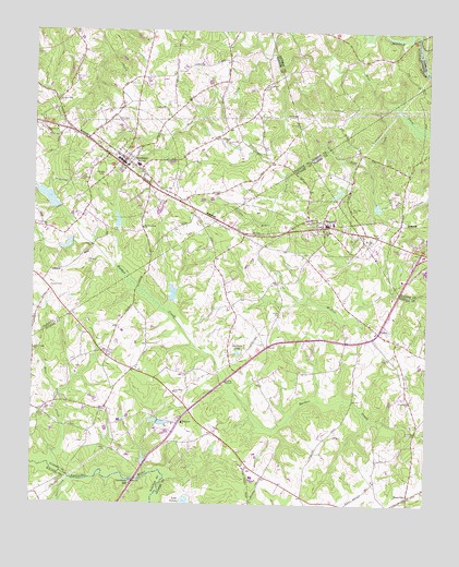
Statham, GA USGS Topographic Map
Click on map above to begin viewing in our Map Viewer.

This topographic map contains these locations and features:
Feature Name Type Latitude Longitude GNIS ID View Map
AllenPopulated PlaceN33.9457°W83.5438°356681View Map
Arch BridgeBridgeN33.8815°W83.5893°356684View Map
AshlandPopulated PlaceN33.9007°W83.5804°356683View Map
Barber CreekReservoirN33.9501°W83.5832°336806View Map
Barber Creek ChurchChurchN33.9479°W83.5899°354455View Map
Barber Creek Watershed Number 26 DamDamN33.9284°W83.5816°336502View Map
Barber Creek Watershed Structure 25 DamDamN33.9501°W83.5832°336805View Map
Barbers Creek School (historical)SchoolN33.9482°W83.5902°356975View Map
Barrow County Fire Station Number 1BuildingN33.9602°W83.6037°2603818View Map
Bethabara CemeteryCemeteryN33.8976°W83.5782°356691View Map
Bethabara ChurchChurchN33.8965°W83.5768°354565View Map
BogartPopulated PlaceN33.9493°W83.5346°354801View Map
Bogart Church of ChristChurchN33.9518°W83.5352°356697View Map
Bogart Developmental CenterSchoolN33.9448°W83.5313°356698View Map
Bogart DivisionCivilN33.9064°W83.5504°1936120View Map
Bogart Post OfficePost OfficeN33.9490°W83.5335°356699View Map
Camps Bridge (historical)BridgeN33.8959°W83.5460°356705View Map
Caruthers MillPopulated PlaceN33.8801°W83.5929°326210View Map
Caruthers SchoolSchoolN33.9046°W83.5793°355018View Map
City of StathamCivilN33.9646°W83.6024°2405527View Map
Cleveland Road Elementary SchoolSchoolN33.9670°W83.5055°2545682View Map
Cleveland StationPopulated PlaceN33.9493°W83.5085°1672775View Map
Connecting Point ChurchChurchN33.9321°W83.5293°2504768View Map
Cornerstone ChurchChurchN33.9879°W83.5829°356996View Map
CrowsLocaleN33.9209°W83.5149°313190View Map
Crows Academy (historical)SchoolN33.9448°W83.5691°356714View Map
Dam Number 26ReservoirN33.9307°W83.5806°336503View Map
DeerbrookPopulated PlaceN33.9209°W83.5032°356719View Map
Deerwood EstatesPopulated PlaceN33.9559°W83.5366°356720View Map
Delay CemeteryCemeteryN33.8998°W83.6032°313431View Map
Dickens LakeReservoirN33.9152°W83.5596°355490View Map
Dove CreekStreamN33.8832°W83.6154°313596View Map
Dove Creek ChurchChurchN33.9157°W83.6246°313598View Map
Dove Creek School (historical)SchoolN33.9154°W83.6243°356722View Map
EastvillePopulated PlaceN33.8776°W83.5049°326258View Map
EnglewoodPopulated PlaceN33.9346°W83.5624°356730View Map
FernwoodPopulated PlaceN33.9246°W83.5427°356735View Map
Fowler Mill (historical)LocaleN33.9657°W83.5227°1672748View Map
Friendship ChurchChurchN33.9021°W83.5046°355948View Map
FrogtownPopulated PlaceN33.9004°W83.6013°356738View Map
Gasaway Dam Number OneDamN33.9001°W83.5849°338574View Map
Gasaway Dam Number TwoDamN33.9018°W83.5866°338576View Map
Gasaway Lake Number OneReservoirN33.9001°W83.5849°338575View Map
Gasaway Lake Number TwoReservoirN33.9018°W83.5866°338577View Map
Greater Barber Creek ChurchChurchN33.9751°W83.5624°357008View Map
GreenePopulated PlaceN33.9540°W83.5304°356741View Map
Griffiths BridgeBridgeN33.9079°W83.5635°356742View Map
Harmony School (historical)SchoolN33.9784°W83.5352°349569View Map
Little Bear CreekStreamN33.9812°W83.5129°316938View Map
Living Word Baptist ChurchChurchN33.9168°W83.5245°2747517View Map
Malcolm BridgeBridgeN33.8946°W83.5029°356761View Map
Malcolm CemeteryCemeteryN33.9029°W83.5052°356762View Map
Malcom Bridge Elementary SchoolSchoolN33.9144°W83.5060°2545576View Map
Malcom Bridge Middle SchoolSchoolN33.9120°W83.5046°2545784View Map
McLocklin LakeReservoirN33.9434°W83.6140°336807View Map
Millsaps CemeteryCemeteryN33.9393°W83.6077°318287View Map
Mount Bethel School (historical)SchoolN33.9923°W83.6110°357017View Map
Mount Zion CemeteryCemeteryN33.9532°W83.5241°318926View Map
Mount Zion ChurchChurchN33.9459°W83.5179°319024View Map
North Oconee High SchoolSchoolN33.8778°W83.5238°2545701View Map
Oak GrovePopulated PlaceN33.9434°W83.5518°356771View Map
Oconee County Fire Department Station 4BuildingN33.9124°W83.5972°2604620View Map
Oconee County Fire Department Station 7BuildingN33.9395°W83.5386°2604570View Map
Oddfellows BridgeBridgeN33.9026°W83.5229°356781View Map
Osceola VillagePopulated PlaceN33.9384°W83.5343°356784View Map
Peppers CemeteryCemeteryN33.9623°W83.6024°320379View Map
Pine RidgePopulated PlaceN33.9423°W83.5388°356788View Map
Pleasant Hill ChurchChurchN33.9823°W83.6177°320905View Map
Pleasant HillsPopulated PlaceN33.9171°W83.5393°356790View Map
Prince Avenue Baptist ChurchChurchN33.9113°W83.5529°1672847View Map
Providence ChurchChurchN33.9859°W83.5513°321203View Map
Rocky Branch Elementary SchoolSchoolN33.8774°W83.5308°2545758View Map
Shoal CreekStreamN33.8818°W83.6124°322934View Map
Sims CemeteryCemeteryN33.8990°W83.6216°323023View Map
StathamPopulated PlaceN33.9651°W83.5966°323543View Map
Statham City CemeteryCemeteryN33.9679°W83.5946°357032View Map
Statham City HallBuildingN33.9657°W83.5960°357033View Map
Statham DivisionCivilN33.9874°W83.6006°1936556View Map
Statham Elementary SchoolSchoolN33.9646°W83.5918°357034View Map
Statham Police DepartmentBuildingN33.9655°W83.5964°2734028View Map
Sykes BridgeBridgeN33.9326°W83.5916°356813View Map
Talassee Bridge (historical)BridgeN33.9996°W83.5035°349579View Map
Talassee ShoalsBarN33.9983°W83.5056°2677713View Map
Town of BogartCivilN33.9474°W83.5335°2405294View Map
Treadwell BridgeBridgeN33.8823°W83.6135°356820View Map
Watershed LakeReservoirN33.9559°W83.6206°336809View Map
Watershed Lake DamDamN33.9534°W83.6182°336808View Map
Watershed Number 9 Barber Creek DamDamN33.9451°W83.6132°344395View Map

Note: Coordinates in the location and feature list above are referenced to NAD83 datum.


Copyright (C) 2008-2024 Ryan Niemi / Sunset Dynamics ... All Rights Reserved