TopoQuest Logo
Do you find TopoQuest useful?
Help keep TopoQuest running and adding new maps/features by donating!
Bitcoin:  19c7KJd3qBynnjoSw5npx9KScwjBe4ifkT
Litecoin:  LXs6TkuXGGXo1vDsWCkWVdjQX94eUKd6ui
Home View Maps Find Maps Find Places Resources & Links


Winder North, Georgia Topographic Map

USGS Map Title: Winder North, GA
USGS Map MRC: 34083A6
DRG (GeoTIFF) Download: o34083a6.tif


Neighboring USGS Topographic Map Quads:


  Chestnut Mountain, GA  
34083B7
 

  Pendergrass, GA  
34083B6
 

  Apple Valley, GA  
34083B5
 

  Auburn, GA  
34083A7
 

  Winder North, GA  
34083A6
 

  Jefferson, GA  
34083A5
 

  Bold Springs, GA  
33083H7
 

  Winder South, GA  
33083H6
 

  Statham, GA  
33083H5


Map MRC Location:

N35°
W84°
N35°
W83°
H8 H7 H6 H5 H4 H3 H2 H1
G8 G7 G6 G5 G4 G3 G2 G1
F8 F7 F6 F5 F4 F3 F2 F1
E8 E7 E6 E5 E4 E3 E2 E1
D8 D7 D6 D5 D4 D3 D2 D1
C8 C7 C6 C5 C4 C3 C2 C1
B8 B7 B6 B5 B4 B3 B2 B1
A8 A7 A6 A5 A4 A3 A2 A1
N34°
W84°
N34°
W83°

Winder North, GA USGS 1:24K Topographic Map Preview:
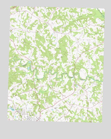
Winder North, GA USGS Topographic Map
Click on map above to begin viewing in our Map Viewer.

This topographic map contains these locations and features:
Feature Name Type Latitude Longitude GNIS ID View Map
Barrow County Fire and Emergency Services Station 6BuildingN34.0058°W83.6442°2604400View Map
Barrow Medical Center HeliportAirportN34.0137°W83.7116°351957View Map
Cedar CreekStreamN34.0484°W83.6863°312461View Map
Center ChurchChurchN34.0804°W83.7127°355076View Map
Center Methodist CemeteryCemeteryN34.0800°W83.7136°349430View Map
Collins School (historical)SchoolN34.0671°W83.6710°349433View Map
County Line Elementary SchoolSchoolN34.0263°W83.7387°356997View Map
Dosters CreekStreamN34.1157°W83.6263°355518View Map
Dosters Family CemeteryCemeteryN34.1149°W83.6647°313556View Map
Ebenezer CemeteryCemeteryN34.0595°W83.6399°349448View Map
Ebenezer ChurchChurchN34.0593°W83.6402°355629View Map
Elmwood School (historical)SchoolN34.1029°W83.6527°349450View Map
Flanagans Mill (historical)LocaleN34.0632°W83.6549°349456View Map
Gum Spring School (historical)SchoolN34.0804°W83.6835°349460View Map
Gum Springs Baptist CemeteryCemeteryN34.0801°W83.6835°349459View Map
Gum Springs ChurchChurchN34.0798°W83.6827°314977View Map
Gum Springs Elementary SchoolSchoolN34.0947°W83.6893°2545751View Map
Guyouzts DamDamN34.0118°W83.6899°338615View Map
Guyouzts LakeReservoirN34.0128°W83.6907°338616View Map
Hancock BridgeBridgeN34.0462°W83.6346°315079View Map
Hawk CreekStreamN34.0476°W83.7124°315240View Map
Holsenbeck Elementary SchoolSchoolN34.0146°W83.6873°315584View Map
Hope Haven MissionChurchN34.0876°W83.6449°349471View Map
Hoschton Police DepartmentBuildingN34.0842°W83.7427°2734188View Map
House CemeteryCemeteryN34.0337°W83.7196°315734View Map
Indian CreekStreamN34.0543°W83.6993°315898View Map
Jackson Trail Christian SchoolSchoolN34.0852°W83.6447°349483View Map
Jackson Trail MonumentParkN34.0851°W83.6304°349482View Map
Jackson Trail Volunteer Fire DepartmentBuildingN34.0863°W83.6610°2603957View Map
Lesters LakeReservoirN34.0396°W83.6595°338902View Map
Lesters Lake DamDamN34.0401°W83.6599°338901View Map
Lyle CemeteryCemeteryN34.0581°W83.7132°317496View Map
Marcus (historical)Populated PlaceN34.0737°W83.6771°1687998View Map
Middle Oconee Walnut Creek 19 DamDamN34.1168°W83.6599°337355View Map
Middle Oconee-Walnut Creek 18 DamDamN34.1118°W83.6666°337359View Map
MulberryPopulated PlaceN34.0446°W83.7168°357018View Map
New Hope ChurchChurchN34.0815°W83.7418°319431View Map
New Hope Methodist CemeteryCemeteryN34.0820°W83.7423°349504View Map
New Pentecost ChurchChurchN34.0168°W83.6435°357020View Map
Northeast Georgia Medical Center BarrowHospitalN34.0081°W83.7078°356979View Map
Oak Grove Baptist CemeteryCemeteryN34.0707°W83.6809°349507View Map
Oak Grove ChurchChurchN34.0707°W83.6807°319809View Map
Reservoir 18ReservoirN34.1118°W83.6666°337360View Map
Reservoir 19ReservoirN34.1172°W83.6595°337356View Map
Rockwell ChurchChurchN34.0351°W83.7132°321780View Map
Rockwell School (historical)SchoolN34.0357°W83.7138°357027View Map
Rocky CreekStreamN34.0540°W83.7188°321825View Map
Rose Hill CemeteryCemeteryN34.0012°W83.7302°321915View Map
SellsPopulated PlaceN34.0671°W83.7227°349525View Map
Sells Mill (historical)LocaleN34.0846°W83.7296°349526View Map
Union ChurchChurchN34.0284°W83.6768°357038View Map
Walnut Fork Baptist CemeteryCemeteryN34.1246°W83.7187°349543View Map
Walnut Fork ChurchChurchN34.1240°W83.7179°324810View Map
West Jackson Middle SchoolSchoolN34.0951°W83.6897°2545750View Map
White Plains Baptist CemeteryCemeteryN34.1001°W83.6684°349545View Map
White Plains ChurchChurchN34.0998°W83.6682°325185View Map
Winder - Barrow High SchoolSchoolN34.0046°W83.7281°357047View Map
Winder DivisionCivilN34.0103°W83.7076°1936650View Map
Winder ReservoirReservoirN34.0121°W83.7416°325443View Map
Winder Reservoir DamDamN34.0121°W83.7407°336798View Map
Wood CemeteryCemeteryN34.0251°W83.6266°325520View Map

Note: Coordinates in the location and feature list above are referenced to NAD83 datum.


Copyright (C) 2008-2024 Ryan Niemi / Sunset Dynamics ... All Rights Reserved