TopoQuest Logo
Do you find TopoQuest useful?
Help keep TopoQuest running and adding new maps/features by donating!
Bitcoin:  19c7KJd3qBynnjoSw5npx9KScwjBe4ifkT
Litecoin:  LXs6TkuXGGXo1vDsWCkWVdjQX94eUKd6ui
Home View Maps Find Maps Find Places Resources & Links


Blakely Island, Washington Topographic Map

USGS Map Title: Blakely Island, WA
USGS Map MRC: 48122E7
DRG (GeoTIFF) Download: o48122e7.tif


Neighboring USGS Topographic Map Quads:


  Eastsound, WA  
48122F8
 

  Mount Constitution, WA  
48122F7
 

  Lummi Island, WA  
48122F6
 

  Shaw Island, WA  
48122E8
 

  Blakely Island, WA  
48122E7
 

  Cypress Island, WA  
48122E6
 

  Richardson, WA  
48122D8
 

  Lopez Pass, WA  
48122D7
 

  Deception Pass, WA  
48122D6


Map MRC Location:

N49°
W123°
N49°
W122°
H8 H7 H6 H5 H4 H3 H2 H1
G8 G7 G6 G5 G4 G3 G2 G1
F8 F7 F6 F5 F4 F3 F2 F1
E8 E7 E6 E5 E4 E3 E2 E1
D8 D7 D6 D5 D4 D3 D2 D1
C8 C7 C6 C5 C4 C3 C2 C1
B8 B7 B6 B5 B4 B3 B2 B1
A8 A7 A6 A5 A4 A3 A2 A1
N48°
W123°
N48°
W122°

Blakely Island, WA USGS 1:24K Topographic Map Preview:
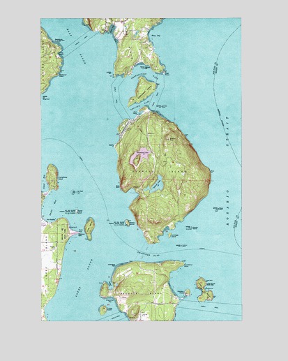
Blakely Island, WA USGS Topographic Map
Click on map above to begin viewing in our Map Viewer.

This topographic map contains these locations and features:
Feature Name Type Latitude Longitude GNIS ID View Map
Armitage IslandIslandN48.5351°W122.7963°1503059View Map
Bald BluffCliffN48.5557°W122.8268°1503139View Map
Black RockIslandN48.5459°W122.7657°1503410View Map
Blakely IslandIslandN48.5620°W122.8016°1503425View Map
Blakely Island AirportAirportN48.5800°W122.8236°1533691View Map
Blakely Island General Store MarinaLocaleN48.5852°W122.8147°2610276View Map
Blakely Island ShoalBarN48.5707°W122.8427°1531900View Map
Blakely PeakSummitN48.5748°W122.7963°1503426View Map
Brigantine BayBayN48.5090°W122.8327°1503547View Map
Brown RockSummitN48.6045°W122.8113°1512037View Map
Buck BayBayN48.6207°W122.8316°1503596View Map
Buoy BayBayN48.6184°W122.8082°1509719View Map
Cascade CreekStreamN48.6223°W122.8318°1503837View Map
Davis BayBayN48.5159°W122.7963°1531397View Map
DecaturPopulated PlaceN48.5004°W122.8196°1534563View Map
Decatur /Jones AirportAirportN48.5101°W122.8030°1533736View Map
Decatur HeadSummitN48.5112°W122.7849°1512140View Map
Decatur IslandIslandN48.5076°W122.8118°1504379View Map
Deer PointCapeN48.6026°W122.7988°1504421View Map
Deer Point Airport (historical)AirportN48.6123°W122.8166°1533860View Map
Diamond PointCapeN48.6015°W122.8652°1504474View Map
East SoundBayN48.5998°W122.8430°1504655View Map
Fauntleroy PointCapeN48.5232°W122.7874°1504839View Map
Flower IslandIslandN48.5445°W122.8538°1504941View Map
Frost IslandIslandN48.5390°W122.8460°1505056View Map
Green BankBeachN48.6123°W122.8618°1531394View Map
Horseshoe LakeLakeN48.5663°W122.8143°1505626View Map
Humphrey HeadCliffN48.5590°W122.8660°1505663View Map
James IslandIslandN48.5126°W122.7752°1505787View Map
James Island State ParkParkN48.5126°W122.7752°1513937View Map
James Island State Park Boat DockLocaleN48.5126°W122.7765°2607955View Map
Lawson RockBarN48.5309°W122.7888°1506113View Map
Leo ReefBarN48.5529°W122.8564°2663356View Map
Leo Reef LightLocaleN48.5532°W122.8541°1506129View Map
Lieber Haven Resort and MarinaLocaleN48.6053°W122.8165°2610352View Map
Lydia ShoalBarN48.6012°W122.7791°1506388View Map
Obstruction IslandIslandN48.5957°W122.8124°1507139View Map
Obstruction PassChannelN48.5957°W122.8121°1507140View Map
OlgaPopulated PlaceN48.6195°W122.8355°1511204View Map
Olga MarinaLocaleN48.6187°W122.8361°2610326View Map
Olga Marine State ParkParkN48.6187°W122.8357°1507164View Map
Olga Post OfficePost OfficeN48.6197°W122.8353°2769198View Map
Peavine PassChannelN48.5890°W122.8130°1507355View Map
Pointer IslandIslandN48.5384°W122.7821°1507544View Map
Port StanleyPopulated PlaceN48.5404°W122.8718°1511239View Map
Rosario StraitChannelN48.5612°W122.7596°1507915View Map
San ElmoSummitN48.5126°W122.8213°1531396View Map
San Juan County Fire District 2 / Orcas Island Fire and Rescue Station 25 Olga / Obstruction PassBuildingN48.6200°W122.8245°2643930View Map
Spencer LakeLakeN48.5558°W122.8044°1508585View Map
Spencer SpitBarN48.5365°W122.8521°1508586View Map
Spencer Spit State ParkParkN48.5365°W122.8621°1511649View Map
Spencer’s Landing MarinaLocaleN48.5566°W122.8729°2610268View Map
Spindle RockBarN48.5882°W122.8010°1508593View Map
Swifts BayBayN48.5470°W122.8688°1508877View Map
Sylvan CoveBayN48.5137°W122.8330°1508884View Map
ThatcherPopulated PlaceN48.5548°W122.8188°1511366View Map
Thatcher BayBayN48.5529°W122.8185°1531395View Map
Thatcher PassChannelN48.5270°W122.8071°1508959View Map
The PointersIslandN48.5393°W122.7838°1531398View Map
Trump IslandIslandN48.5043°W122.8374°1509093View Map
Turek DamDamN48.6182°W122.8146°1532617View Map
Twin RocksIslandN48.6157°W122.8649°1509155View Map
Undertakers ReefBarN48.5229°W122.8299°1511702View Map
White BeachBeachN48.6104°W122.8652°1509460View Map
Willow IslandIslandN48.5401°W122.8221°1509553View Map

Note: Coordinates in the location and feature list above are referenced to NAD83 datum.


Copyright (C) 2008-2024 Ryan Niemi / Sunset Dynamics ... All Rights Reserved