TopoQuest Logo
Do you find TopoQuest useful?
Help keep TopoQuest running and adding new maps/features by donating!
Bitcoin:  19c7KJd3qBynnjoSw5npx9KScwjBe4ifkT
Litecoin:  LXs6TkuXGGXo1vDsWCkWVdjQX94eUKd6ui
Home View Maps Find Maps Find Places Resources & Links


Eastsound, Washington Topographic Map

USGS Map Title: Eastsound, WA
USGS Map MRC: 48122F8
DRG (GeoTIFF) Download: o48122f8.tif


Neighboring USGS Topographic Map Quads:


  Sucia Island, WA  
48122G8


  Waldron Island, WA  
48123F1
 

  Eastsound, WA  
48122F8
 

  Mount Constitution, WA  
48122F7
 

  Friday Harbor, WA  
48123E1
 

  Shaw Island, WA  
48122E8
 

  Blakely Island, WA  
48122E7


Map MRC Location:

N49°
W123°
N49°
W122°
H8 H7 H6 H5 H4 H3 H2 H1
G8 G7 G6 G5 G4 G3 G2 G1
F8 F7 F6 F5 F4 F3 F2 F1
E8 E7 E6 E5 E4 E3 E2 E1
D8 D7 D6 D5 D4 D3 D2 D1
C8 C7 C6 C5 C4 C3 C2 C1
B8 B7 B6 B5 B4 B3 B2 B1
A8 A7 A6 A5 A4 A3 A2 A1
N48°
W123°
N48°
W122°

Eastsound, WA USGS 1:24K Topographic Map Preview:
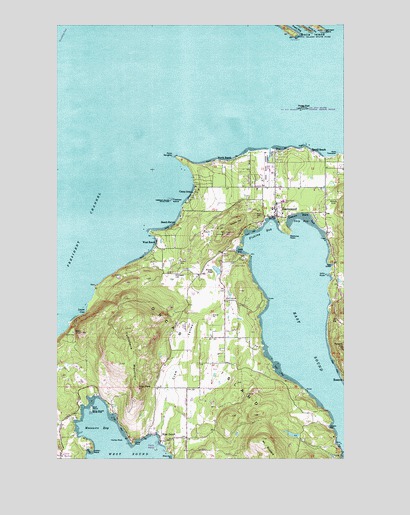
Eastsound, WA USGS Topographic Map
Click on map above to begin viewing in our Map Viewer.

This topographic map contains these locations and features:
Feature Name Type Latitude Longitude GNIS ID View Map
Ayer ReservoirReservoirN48.6318°W122.8989°1532142View Map
Ayer Reservoir DamDamN48.6315°W122.8963°1532141View Map
Beach HavenPopulated PlaceN48.6920°W122.9507°1511990View Map
Brandts Landing Eastsound MarinaLocaleN48.7126°W122.9083°2610325View Map
Camp OrkilaPopulated PlaceN48.7012°W122.9419°1512061View Map
Coon HollowBayN48.6807°W122.8816°1504129View Map
Crescent BeachBeachN48.6951°W122.8952°1504267View Map
Crow ValleyValleyN48.6329°W122.9577°1504288View Map
DolphinPopulated PlaceN48.6515°W122.9093°1534149View Map
Dolphin BayBayN48.6340°W122.8824°1504502View Map
Dolphin Bay QuarryMineN48.6444°W122.9150°2605648View Map
Double HillSummitN48.6940°W122.9241°1512159View Map
Eagle's Rock Christian Fellowship ChurchChurchN48.6954°W122.9035°2609449View Map
EastsoundPopulated PlaceN48.6968°W122.9055°1513104View Map
Eastsound Post OfficePost OfficeN48.6970°W122.9077°2606945View Map
Elco PitMineN48.6655°W122.9345°2605649View Map
Emmanuel Episcopal ChurchChurchN48.6944°W122.9073°2609042View Map
Ev Henry PointCapeN48.7470°W122.8964°2761378View Map
Fishing BayBayN48.6898°W122.9116°1504913View Map
Fowler PondReservoirN48.6791°W122.9316°1513926View Map
Fowler Reservoir DamDamN48.6798°W122.9313°1532143View Map
Freeman IslandIslandN48.6993°W122.9519°1505035View Map
Freeman Island State ParkParkN48.6993°W122.9516°1513927View Map
Giffin RocksBarN48.6779°W122.8841°1513570View Map
Haida PointCapeN48.6290°W122.9680°1505338View Map
Harbor RockBarN48.6301°W122.9777°1505386View Map
Indian PointCapeN48.6270°W122.9860°1505727View Map
Johnson PointCapeN48.7484°W122.8841°1505850View Map
Judd BayBayN48.6848°W122.9224°1505873View Map
Kimple BeachBeachN48.6870°W122.9569°1531379View Map
Lookout HillSummitN48.6898°W122.9282°1512402View Map
Lovers CoveBayN48.6673°W122.9885°1506346View Map
Madrona PointCapeN48.6895°W122.8994°1506420View Map
Massacre BayBayN48.6337°W122.9818°1506505View Map
Mount WoolardSummitN48.6307°W122.9118°1513958View Map
North BeachBeachN48.7107°W122.9282°1507017View Map
Orcas Christian SchoolSchoolN48.6983°W122.9079°2606432View Map
Orcas DivisionCivilN48.6890°W122.9137°1939590View Map
Orcas IslandIslandN48.6543°W122.9382°1507196View Map
Orcas Island AirportAirportN48.7063°W122.9096°1533741View Map
Orcas Island Community ChurchChurchN48.6956°W122.9027°2609450View Map
Orcas Island Elementary SchoolSchoolN48.6989°W122.9036°1514954View Map
Orcas Island Golf CourseLocaleN48.6711°W122.9253°2608183View Map
Orcas Island High SchoolSchoolN48.6988°W122.9031°1531051View Map
Orcas Island Historical MuseumBuildingN48.6955°W122.9059°2610408View Map
Orcas Island LibraryBuildingN48.6968°W122.9042°2610152View Map
Orcas Island Middle SchoolSchoolN48.6988°W122.9025°2518477View Map
Orcas Island Seventh Day Adventist ChurchChurchN48.6992°W122.9077°2608499View Map
Orcas Island Transfer Station Solid Waste FacilityLocaleN48.6620°W122.9374°2605562View Map
Orcas Island Yacht ClubLocaleN48.6313°W122.9617°2610358View Map
Orcas KnobSummitN48.6612°W122.9905°1507197View Map
Osprey HillSummitN48.6734°W122.9213°1802934View Map
Parker ReefBarN48.7259°W122.8944°1507308View Map
Picnic IslandIslandN48.6276°W122.9582°1508276View Map
Point DoughtyCapeN48.7118°W122.9496°1507512View Map
Point KimpleCapeN48.6904°W122.9602°1531378View Map
Point ThompsonCapeN48.7129°W122.8791°1507536View Map
RosarioPopulated PlaceN48.6487°W122.8760°1512618View Map
Rosario HillSummitN48.6568°W122.8768°1507913View Map
Salmonberry SchoolSchoolN48.7021°W122.9066°2605877View Map
San Juan County Fire District 2 / Orcas Island Fire and Rescue Station 21 Eastsound / HeadquartersBuildingN48.7024°W122.9083°2606043View Map
San Juan County Fire District 2 / Orcas Island Fire and Rescue Station 22 WestsoundBuildingN48.6311°W122.9465°2643927View Map
Schaefer LakeReservoirN48.6426°W122.9422°1532823View Map
Schaefer LakeLakeN48.6401°W122.9924°1531380View Map
Schaefer Lake DamDamN48.6432°W122.9430°1532822View Map
Sea Island Shale PitMineN48.6427°W122.9207°2605650View Map
Ship BayBayN48.6937°W122.8946°1508309View Map
Ship PeakPillarN48.6457°W122.9657°1508311View Map
Skull IslandIslandN48.6393°W122.9863°1508398View Map
Skull Island State ParkParkN48.6390°W122.9860°1513951View Map
Skull RockIslandN48.6393°W122.9874°1514940View Map
Smith DamDamN48.6632°W122.9546°1532619View Map
Snoring BayBayN48.7495°W122.8924°1508475View Map
Terrill BeachBeachN48.7134°W122.8902°1508955View Map
Tourtleback LakeReservoirN48.6634°W122.9459°1532629View Map
Tourtleback Lake DamDamN48.6632°W122.9463°1532628View Map
Turtleback MountainSummitN48.6559°W122.9666°1509136View Map
West BeachPopulated PlaceN48.6873°W122.9577°1512787View Map
West Beach Resort Campground and Recreational Vehicle ParkLocaleN48.6882°W122.9577°2608273View Map
West SoundPopulated PlaceN48.6312°W122.9563°1512796View Map
West Sound MarinaLocaleN48.6295°W122.9579°2610269View Map
White Beach BayBayN48.6251°W122.9535°1509461View Map
Wiggins HeadCapeN48.7482°W122.8930°1509701View Map
Woodlawn CemeteryCemeteryN48.6785°W122.9498°1509623View Map

Note: Coordinates in the location and feature list above are referenced to NAD83 datum.


Copyright (C) 2008-2024 Ryan Niemi / Sunset Dynamics ... All Rights Reserved