TopoQuest Logo
Do you find TopoQuest useful?
Help keep TopoQuest running and adding new maps/features by donating!
Bitcoin:  19c7KJd3qBynnjoSw5npx9KScwjBe4ifkT
Litecoin:  LXs6TkuXGGXo1vDsWCkWVdjQX94eUKd6ui
Home View Maps Find Maps Find Places Resources & Links


Stigler NE, Oklahoma Topographic Map

USGS Map Title: Stigler NE, OK
USGS Map MRC: 35095D1
DRG (GeoTIFF) Download: o35095d1.tif


Neighboring USGS Topographic Map Quads:


  Webbers Falls, OK  
35095E2
 

  Gore, OK  
35095E1
 

  Blackgum, OK  
35094E8
 

  Holt Mountain, OK  
35095D2
 

  Stigler NE, OK  
35095D1
 

  Vian, OK  
35094D8
 

  Stigler West, OK  
35095C2
 

  Stigler East, OK  
35095C1
 

  Keota, OK  
35094C8


Map MRC Location:

N36°
W96°
N36°
W95°
H8 H7 H6 H5 H4 H3 H2 H1
G8 G7 G6 G5 G4 G3 G2 G1
F8 F7 F6 F5 F4 F3 F2 F1
E8 E7 E6 E5 E4 E3 E2 E1
D8 D7 D6 D5 D4 D3 D2 D1
C8 C7 C6 C5 C4 C3 C2 C1
B8 B7 B6 B5 B4 B3 B2 B1
A8 A7 A6 A5 A4 A3 A2 A1
N35°
W96°
N35°
W95°

Stigler NE, OK USGS 1:24K Topographic Map Preview:
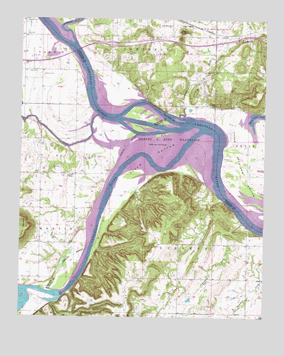
Stigler NE, OK USGS Topographic Map
Click on map above to begin viewing in our Map Viewer.

This topographic map contains these locations and features:
Feature Name Type Latitude Longitude GNIS ID View Map
Brier CreekStreamN35.4143°W95.0102°1090493View Map
Canadian RiverStreamN35.4534°W95.0327°1101881View Map
Carlile CemeteryCemeteryN35.4970°W95.0861°1090966View Map
Clark CemeteryCemeteryN35.4293°W95.0858°1091390View Map
Dirty CreekStreamN35.4595°W95.0861°1092094View Map
Fields CemeteryCemeteryN35.4751°W95.0313°1092804View Map
Foreman CemeteryCemeteryN35.4970°W95.0972°1092928View Map
Girty CemeteryCemeteryN35.4059°W95.0997°1093195View Map
Hanks CemeteryCemeteryN35.4870°W95.1025°1093512View Map
Harris MountainSummitN35.4129°W95.1202°1093572View Map
Hefley CemeteryCemeteryN35.4776°W95.1175°1093646View Map
Hisaw BottomBendN35.4420°W95.0572°1093797View Map
Illinois RiverStreamN35.4893°W95.0977°1094043View Map
Jones CemeteryCemeteryN35.4840°W95.1161°1094260View Map
Kyle CemeteryCemeteryN35.4226°W95.0888°1094443View Map
McIntosh ChapelChurchN35.4348°W95.0983°1095244View Map
Negro CreekStreamN35.4590°W95.0444°1095774View Map
Oknoname 111032 DamDamN35.4301°W95.0352°1752517View Map
Oknoname 111032 ReservoirReservoirN35.4301°W95.0352°1752518View Map
Red Hill CemeteryCemeteryN35.4418°W95.0913°1097101View Map
Rock Hill ChurchChurchN35.4779°W95.0283°1097349View Map
Round MountainSummitN35.4948°W95.0436°1097496View Map
Round Mountain CemeteryCemeteryN35.4983°W95.0489°2710981View Map
Round Mountain ChurchChurchN35.4976°W95.0491°1097502View Map
Sally Jones LakeReservoirN35.4598°W95.0008°1097666View Map
Sandtown CemeteryCemeteryN35.4418°W95.0180°1097791View Map
Sequoyah National Wildlife RefugeParkN35.4370°W95.0326°1100112View Map
Starr CemeteryCemeteryN35.4937°W95.1222°1098503View Map
Stony Point ChurchChurchN35.4634°W95.0263°1098567View Map
Toney CemeteryCemeteryN35.4376°W95.1050°1098938View Map
Town of TamahaCivilN35.4059°W95.0180°2413365View Map
Township of LibertyCivilN35.3807°W95.0030°1824651View Map
Upper Sandtown BottomBendN35.4351°W95.0150°1099192View Map
Upson SidingLocaleN35.4976°W95.0380°1099194View Map
Vann CemeteryCemeteryN35.4365°W95.0794°1099224View Map
Webbers Falls (historical)FallsN35.4608°W95.0544°2437549View Map
Wilkerson CemeteryCemeteryN35.4768°W95.1133°1099813View Map
Wilkerson CemeteryCemeteryN35.4812°W95.1233°1099814View Map

Note: Coordinates in the location and feature list above are referenced to NAD83 datum.


Copyright (C) 2008-2025 Ryan Niemi / Sunset Dynamics ... All Rights Reserved