TopoQuest Logo
Do you find TopoQuest useful?
Help keep TopoQuest running and adding new maps/features by donating!
Bitcoin:  19c7KJd3qBynnjoSw5npx9KScwjBe4ifkT
Litecoin:  LXs6TkuXGGXo1vDsWCkWVdjQX94eUKd6ui
Home View Maps Find Maps Find Places Resources & Links


Stockton, Illinois Topographic Map

USGS Map Title: Stockton, IL
USGS Map MRC: 42090C1
DRG (GeoTIFF) Download: o42090c1.tif


Neighboring USGS Topographic Map Quads:


  Scales Mound East, IL  
42090D2
 

  Elizabeth NE, IL  
42090D1
 

  Warren, IL  
42089D8
 

  Elizabeth, IL  
42090C2
 

  Stockton, IL  
42090C1
 

  Kent, IL  
42089C8
 

  Blackhawk, IL  
42090B2
 

  Pleasant Valley, IL  
42090B1
 

  Loran, IL  
42089B8


Map MRC Location:

N43°
W91°
N43°
W90°
H8 H7 H6 H5 H4 H3 H2 H1
G8 G7 G6 G5 G4 G3 G2 G1
F8 F7 F6 F5 F4 F3 F2 F1
E8 E7 E6 E5 E4 E3 E2 E1
D8 D7 D6 D5 D4 D3 D2 D1
C8 C7 C6 C5 C4 C3 C2 C1
B8 B7 B6 B5 B4 B3 B2 B1
A8 A7 A6 A5 A4 A3 A2 A1
N42°
W91°
N42°
W90°

Stockton, IL USGS 1:24K Topographic Map Preview:
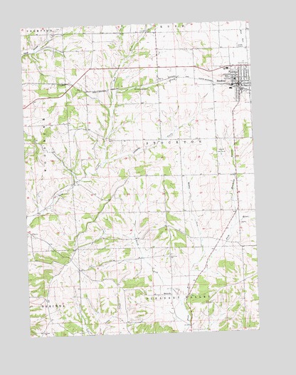
Stockton, IL USGS Topographic Map
Click on map above to begin viewing in our Map Viewer.

This topographic map contains these locations and features:
Feature Name Type Latitude Longitude GNIS ID View Map
Calvary United Methodist ChurchChurchN42.3547°W90.0118°1866515View Map
Country Air Mobile Home EstatesPopulated PlaceN42.3447°W90.0017°2630570View Map
Derinda Post Office (historical)Post OfficeN42.2811°W90.1015°1815770View Map
ElmovillePopulated PlaceN42.2656°W90.0471°422666View Map
Hammond BranchStreamN42.2931°W90.0115°409715View Map
Holy Cross Catholic CemeteryCemeteryN42.3575°W90.0021°410433View Map
Holy Cross ChurchChurchN42.3506°W90.0051°1866516View Map
J and J Mobile Home ParkPopulated PlaceN42.3469°W90.0042°2630572View Map
Lawhorn CreekStreamN42.3195°W90.0818°411854View Map
Middle Fork Plum RiverStreamN42.2747°W90.0368°413498View Map
Millershone QuarryMineN42.3286°W90.0787°1987469View Map
Montrose School (historical)SchoolN42.2758°W90.0965°1718975View Map
Mount Juliet School (historical)SchoolN42.3506°W90.0907°1718977View Map
North Fork Plum RiverStreamN42.2628°W90.0426°414602View Map
Pitcherville (historical)Populated PlaceN42.3645°W90.0018°1815794View Map
Plum River Catholic CemeteryCemeteryN42.2806°W90.0476°415960View Map
Rindesbacher CreekStreamN42.3453°W90.0757°416681View Map
Rush Post Office (historical)Post OfficeN42.3717°W90.0510°1815800View Map
Saint John ChurchChurchN42.2514°W90.1173°417351View Map
Spring Valley School (historical)SchoolN42.3206°W90.0096°1718979View Map
StocktonPopulated PlaceN42.3497°W90.0068°419153View Map
Stockton Center School (historical)SchoolN42.3283°W90.0396°1718978View Map
Stockton Church of the NazareneChurchN42.3495°W90.0057°1866517View Map
Stockton Community AmbulanceBuildingN42.3492°W90.0060°2674031View Map
Stockton Elementary SchoolSchoolN42.3520°W90.0090°1815808View Map
Stockton Fire Protection DistrictBuildingN42.3502°W90.0062°2640262View Map
Stockton Golf CourseLocaleN42.3231°W90.0179°425523View Map
Stockton High SchoolSchoolN42.3564°W90.0129°1718974View Map
Stockton Police DepartmentBuildingN42.3501°W90.0085°2757067View Map
Stockton Post OfficePost OfficeN42.3486°W90.0087°2788505View Map
Township of StocktonCivilN42.3281°W90.0402°429801View Map
Unitarian Universalist ChurchChurchN42.3514°W90.0082°1866518View Map
Village of StocktonCivilN42.3520°W90.0008°2399905View Map
Wesley United Methodist ChurchChurchN42.3511°W90.0057°1866519View Map
West Point School (historical)SchoolN42.3314°W90.1196°1718976View Map
Winters Post Office (historical)Post OfficeN42.3172°W90.0401°1815819View Map
Yankee Hollow Post Office (historical)Post OfficeN42.2883°W90.0287°1815821View Map
Yankee Hollow School (historical)SchoolN42.2881°W90.0237°1718980View Map

Note: Coordinates in the location and feature list above are referenced to NAD83 datum.


Copyright (C) 2008-2025 Ryan Niemi / Sunset Dynamics ... All Rights Reserved