TopoQuest Logo
Do you find TopoQuest useful?
Help keep TopoQuest running and adding new maps/features by donating!
Bitcoin:  19c7KJd3qBynnjoSw5npx9KScwjBe4ifkT
Litecoin:  LXs6TkuXGGXo1vDsWCkWVdjQX94eUKd6ui
Home View Maps Find Maps Find Places Resources & Links


Strawberry, Arkansas Topographic Map

USGS Map Title: Strawberry, AR
USGS Map MRC: 35091H3
DRG (GeoTIFF) Download: o35091h3.tif


Neighboring USGS Topographic Map Quads:


  Poughkeepsie, AR  
36091A4
 

  Smithville, AR  
36091A3
 

  Eaton, AR  
36091A2
 

  Grange, AR  
35091H4
 

  Strawberry, AR  
35091H3
 

  Strangers Home, AR  
35091H2
 

  Charlotte, AR  
35091G4
 

  Cord, AR  
35091G3
 

  Swifton West, AR  
35091G2


Map MRC Location:

N36°
W92°
N36°
W91°
H8 H7 H6 H5 H4 H3 H2 H1
G8 G7 G6 G5 G4 G3 G2 G1
F8 F7 F6 F5 F4 F3 F2 F1
E8 E7 E6 E5 E4 E3 E2 E1
D8 D7 D6 D5 D4 D3 D2 D1
C8 C7 C6 C5 C4 C3 C2 C1
B8 B7 B6 B5 B4 B3 B2 B1
A8 A7 A6 A5 A4 A3 A2 A1
N35°
W92°
N35°
W91°

Strawberry, AR USGS 1:24K Topographic Map Preview:
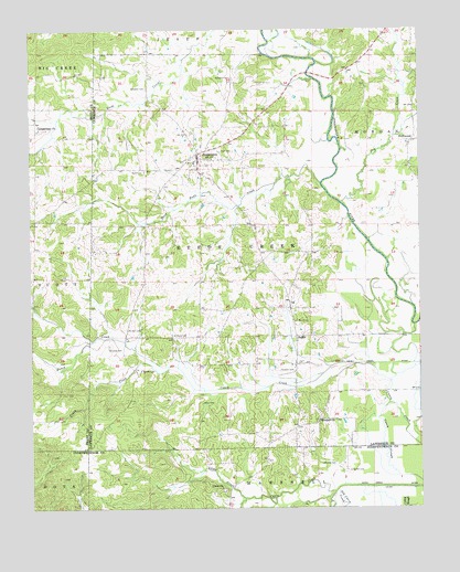
Strawberry, AR USGS Topographic Map
Click on map above to begin viewing in our Map Viewer.

This topographic map contains these locations and features:
Feature Name Type Latitude Longitude GNIS ID View Map
Ashby CemeteryCemeteryN35.9023°W91.3204°45953View Map
Campbell CemeteryCemeteryN35.9173°W91.3504°47344View Map
Campground ChurchChurchN35.9745°W91.3721°47359View Map
Caney Creek DitchCanalN35.9126°W91.2696°47435View Map
Caney SloughStreamN35.9020°W91.2601°47441View Map
Curia CreekStreamN35.8790°W91.2779°76730View Map
Curia Creek DitchCanalN35.8804°W91.2601°48266View Map
DriftwoodPopulated PlaceN35.9712°W91.2521°48604View Map
Durfee CemeteryCemeteryN35.8845°W91.2729°48718View Map
Godwin CemeteryCemeteryN35.9109°W91.2951°49468View Map
Hillcrest High SchoolSchoolN35.9652°W91.3224°2092996View Map
Jerusalem CemeteryCemeteryN35.9873°W91.3098°50632View Map
Lancaster CemeteryCemeteryN35.9851°W91.3373°50969View Map
Little CreekStreamN35.8773°W91.3065°51235View Map
Lockheart (historical)Populated PlaceN35.8765°W91.2960°68022View Map
McNutt CemeteryCemeteryN35.8862°W91.2821°51878View Map
Morgan CreekStreamN35.9726°W91.2579°45757View Map
Mount Zion CemeteryCemeteryN35.9223°W91.3396°52448View Map
Penn CemeteryCemeteryN35.9684°W91.3101°53271View Map
Piney CreekStreamN35.9120°W91.3304°53478View Map
River Valley Elementary SchoolSchoolN35.9659°W91.3217°2093008View Map
River Valley High SchoolSchoolN35.9659°W91.3218°2039043View Map
Rosebud ChurchChurchN35.8979°W91.2829°54209View Map
Runyan CemeteryCemeteryN35.9112°W91.3398°54272View Map
Runyans LakeReservoirN35.9484°W91.3685°80958View Map
Runyans Lake DamDamN35.9484°W91.3685°80957View Map
SaffellPopulated PlaceN35.9198°W91.2901°58565View Map
Saffell Volunteer Fire DepartmentBuildingN35.9128°W91.2900°2117080View Map
Steep Bank CreekStreamN35.9601°W91.2815°55192View Map
StrawberryPopulated PlaceN35.9676°W91.3212°55268View Map
Strawberry Elementary SchoolSchoolN35.9659°W91.3224°61583View Map
Strawberry High SchoolSchoolN35.9654°W91.3224°61582View Map
Strawberry Volunteer Fire DepartmentBuildingN35.9676°W91.3204°2117176View Map
Town of StrawberryCivilN35.9666°W91.3201°2406674View Map
Township of Reeds CreekCivilN35.9364°W91.3068°66799View Map
Union ChurchChurchN35.8801°W91.3140°55803View Map
Ward CemeteryCemeteryN35.9237°W91.2901°56041View Map
Ward CemeteryCemeteryN35.9631°W91.3382°56042View Map
Willmuth CemeteryCemeteryN35.9198°W91.3273°56412View Map

Note: Coordinates in the location and feature list above are referenced to NAD83 datum.


Copyright (C) 2008-2025 Ryan Niemi / Sunset Dynamics ... All Rights Reserved