TopoQuest Logo
Do you find TopoQuest useful?
Help keep TopoQuest running and adding new maps/features by donating!
Bitcoin:  19c7KJd3qBynnjoSw5npx9KScwjBe4ifkT
Litecoin:  LXs6TkuXGGXo1vDsWCkWVdjQX94eUKd6ui
Home View Maps Find Maps Find Places Resources & Links


Stronghurst, Illinois Topographic Map

USGS Map Title: Stronghurst, IL
USGS Map MRC: 40090F8
DRG (GeoTIFF) Download: o40090f8.tif


Neighboring USGS Topographic Map Quads:


  Burlington, IA  
40091G1
 

  Gladstone, IL  
40090G8
 

  Kirkwood West, IL  
40090G7
 

  Lomax, IL  
40091F1
 

  Stronghurst, IL  
40090F8
 

  Raritan, IL  
40090F7
 

  Burnside, IL  
40091E1
 

  La Harpe, IL  
40090E8
 

  Blandinsville, IL  
40090E7


Map MRC Location:

N41°
W91°
N41°
W90°
H8 H7 H6 H5 H4 H3 H2 H1
G8 G7 G6 G5 G4 G3 G2 G1
F8 F7 F6 F5 F4 F3 F2 F1
E8 E7 E6 E5 E4 E3 E2 E1
D8 D7 D6 D5 D4 D3 D2 D1
C8 C7 C6 C5 C4 C3 C2 C1
B8 B7 B6 B5 B4 B3 B2 B1
A8 A7 A6 A5 A4 A3 A2 A1
N40°
W91°
N40°
W90°

Stronghurst, IL USGS 1:24K Topographic Map Preview:
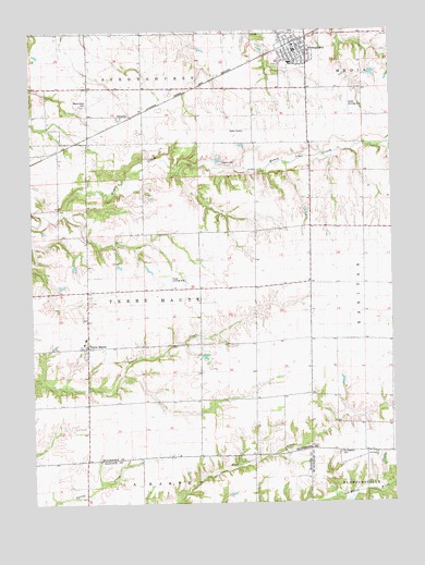
Stronghurst, IL USGS Topographic Map
Click on map above to begin viewing in our Map Viewer.

This topographic map contains these locations and features:
Feature Name Type Latitude Longitude GNIS ID View Map
Bedford School (historical)SchoolN40.6456°W90.8754°1719520View Map
Chandler School (historical)SchoolN40.6814°W90.9815°1719524View Map
Clover Landing Strip (historical)AirportN40.6848°W90.9518°1719525View Map
Cork School (historical)SchoolN40.6970°W90.9221°1719526View Map
DecorraPopulated PlaceN40.7278°W90.9701°422609View Map
Fitz School (historical)SchoolN40.7106°W90.9910°1719536View Map
Henderson School (historical)SchoolN40.6520°W90.9332°1719541View Map
La Harpe Fire Protection District Station 2BuildingN40.6648°W90.9808°2640763View Map
Maple Grove CemeteryCemeteryN40.7311°W90.9807°412924View Map
Maple Grove School (historical)SchoolN40.7348°W90.9793°1719546View Map
Media - Stronghurst - Terre Haute Fire Protection District Station 1 HeadquartersBuildingN40.7458°W90.9063°2640253View Map
Neff Airport (historical)AirportN40.7314°W90.8893°427856View Map
Old Bedford CemeteryCemeteryN40.6384°W90.8940°414986View Map
Old Bedford Christian ChurchChurchN40.6378°W90.8810°414987View Map
Peasley CemeteryCemeteryN40.7148°W90.9335°415497View Map
Peasley School (historical)SchoolN40.7187°W90.9613°1719550View Map
South Henderson County Ambulance ServiceBuildingN40.7457°W90.9066°2673880View Map
South Prairie School (historical)SchoolN40.7495°W90.9332°1719562View Map
South School (historical)SchoolN40.6509°W90.9913°1719564View Map
Southern Elementary SchoolSchoolN40.7414°W90.9093°1812524View Map
Southern High SchoolSchoolN40.7412°W90.9101°1812525View Map
Stine School (historical)SchoolN40.6689°W90.9040°1719567View Map
StronghurstPopulated PlaceN40.7470°W90.9040°419229View Map
Stronghurst Post OfficePost OfficeN40.7450°W90.9085°2788335View Map
Terre HautePopulated PlaceN40.6664°W90.9813°419604View Map
Terre Haute CemeteryCemeteryN40.6736°W90.9812°1968264View Map
Township of Terre HauteCivilN40.6785°W90.9628°429829View Map
Village of StronghurstCivilN40.7464°W90.9093°2399921View Map

Note: Coordinates in the location and feature list above are referenced to NAD83 datum.


Copyright (C) 2008-2025 Ryan Niemi / Sunset Dynamics ... All Rights Reserved