TopoQuest Logo
Do you find TopoQuest useful?
Help keep TopoQuest running and adding new maps/features by donating!
Bitcoin:  19c7KJd3qBynnjoSw5npx9KScwjBe4ifkT
Litecoin:  LXs6TkuXGGXo1vDsWCkWVdjQX94eUKd6ui
Home View Maps Find Maps Find Places Resources & Links


La Harpe, Illinois Topographic Map

USGS Map Title: La Harpe, IL
USGS Map MRC: 40090E8
DRG (GeoTIFF) Download: o40090e8.tif


Neighboring USGS Topographic Map Quads:


  Lomax, IL  
40091F1
 

  Stronghurst, IL  
40090F8
 

  Raritan, IL  
40090F7
 

  Burnside, IL  
40091E1
 

  La Harpe, IL  
40090E8
 

  Blandinsville, IL  
40090E7
 

  Carthage East, IL  
40091D1
 

  Fountain Green, IL  
40090D8
 

  Colchester, IL  
40090D7


Map MRC Location:

N41°
W91°
N41°
W90°
H8 H7 H6 H5 H4 H3 H2 H1
G8 G7 G6 G5 G4 G3 G2 G1
F8 F7 F6 F5 F4 F3 F2 F1
E8 E7 E6 E5 E4 E3 E2 E1
D8 D7 D6 D5 D4 D3 D2 D1
C8 C7 C6 C5 C4 C3 C2 C1
B8 B7 B6 B5 B4 B3 B2 B1
A8 A7 A6 A5 A4 A3 A2 A1
N40°
W91°
N40°
W90°

La Harpe, IL USGS 1:24K Topographic Map Preview:
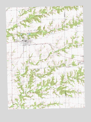
La Harpe, IL USGS Topographic Map
Click on map above to begin viewing in our Map Viewer.

This topographic map contains these locations and features:
Feature Name Type Latitude Longitude GNIS ID View Map
Baptist CreekStreamN40.5217°W90.9704°403882View Map
Chapel CemeteryCemeteryN40.5960°W90.9049°405958View Map
City of La HarpeCivilN40.5848°W90.9695°2395566View Map
Duncan CemeteryCemeteryN40.5502°W90.9011°407484View Map
Eagle School (historical)SchoolN40.5123°W90.9454°1719243View Map
Elder Grove School (historical)SchoolN40.5400°W90.9329°1719244View Map
Elm Grove School (historical)SchoolN40.5873°W90.9254°1719246View Map
Gilead School (historical)SchoolN40.6189°W90.9237°1719252View Map
Harris School (historical)SchoolN40.5650°W90.8946°1719198View Map
Hickory Grove School (historical)SchoolN40.5084°W90.9160°1719253View Map
Hillsborough Baptist Church (historical)ChurchN40.5978°W90.8854°1824385View Map
Hillsborough CemeteryCemeteryN40.6009°W90.8854°410290View Map
La HarpePopulated PlaceN40.5834°W90.9693°411646View Map
La Harpe Ambulance ServiceBuildingN40.5834°W90.9596°2673972View Map
La Harpe Fire Protection District Station 1BuildingN40.5821°W90.9685°2640861View Map
La Harpe High SchoolSchoolN40.5842°W90.9746°1812497View Map
La Harpe Historic DistrictParkN40.5834°W90.9696°1812498View Map
La Harpe Police DepartmentBuildingN40.5833°W90.9671°2756768View Map
La Harpe Post OfficePost OfficeN40.5832°W90.9673°2788854View Map
LaHarpe City CemeteryCemeteryN40.5859°W90.9640°1984101View Map
Little CreekStreamN40.5173°W90.9779°412322View Map
Mayor Memorial ParkParkN40.5870°W90.9771°413166View Map
Morton AirportAirportN40.5873°W90.9431°427428View Map
Mount Pleasant School (historical)SchoolN40.5939°W90.8851°1719208View Map
North Prairie School (historical)SchoolN40.6214°W90.9735°1719263View Map
Oak Hill School (historical)SchoolN40.5642°W90.9299°1719265View Map
Robin Glenn School (historical)SchoolN40.5345°W90.8835°1719217View Map
Rock CreekStreamN40.5064°W90.9851°416803View Map
Rock Creek Methodist Episcopal Church (historical)ChurchN40.5053°W90.8857°1824456View Map
Rock Creek School (historical)SchoolN40.5053°W90.8862°1719218View Map
Rossville School (historical)SchoolN40.5323°W90.9974°1719269View Map
Spiker School (historical)SchoolN40.6195°W90.8851°1719220View Map
Tarman School (historical)SchoolN40.5631°W90.9682°1719271View Map
Township of Fountain GreenCivilN40.5047°W90.9650°429019View Map
Township of La HarpeCivilN40.5930°W90.9639°429221View Map
Twin Oaks Country ClubLocaleN40.5553°W90.8801°425579View Map
Voel CreekStreamN40.6067°W90.9788°420335View Map
Wesley Chapel (historical)ChurchN40.5956°W90.9054°1824500View Map
Wilson CemeteryCemeteryN40.5823°W90.8843°1954747View Map

Note: Coordinates in the location and feature list above are referenced to NAD83 datum.


Copyright (C) 2008-2024 Ryan Niemi / Sunset Dynamics ... All Rights Reserved