TopoQuest Logo
Do you find TopoQuest useful?
Help keep TopoQuest running and adding new maps/features by donating!
Bitcoin:  19c7KJd3qBynnjoSw5npx9KScwjBe4ifkT
Litecoin:  LXs6TkuXGGXo1vDsWCkWVdjQX94eUKd6ui
Home View Maps Find Maps Find Places Resources & Links


Bland, New Mexico Topographic Map

USGS Map Title: Bland, NM
USGS Map MRC: 35106G4
DRG (GeoTIFF) Download: o35106g4.tif


Neighboring USGS Topographic Map Quads:


  Valle San Antonio, NM  
35106H5
 

  Valle Toledo, NM  
35106H4
 

  Guaje Mountain, NM  
35106H3
 

  Redondo Peak, NM  
35106G5
 

  Bland, NM  
35106G4
 

  Frijoles, NM  
35106G3
 

  Bear Springs Peak, NM  
35106F5
 

  Canada, NM  
35106F4
 

  Cochiti Dam, NM  
35106F3


Map MRC Location:

N36°
W107°
N36°
W106°
H8 H7 H6 H5 H4 H3 H2 H1
G8 G7 G6 G5 G4 G3 G2 G1
F8 F7 F6 F5 F4 F3 F2 F1
E8 E7 E6 E5 E4 E3 E2 E1
D8 D7 D6 D5 D4 D3 D2 D1
C8 C7 C6 C5 C4 C3 C2 C1
B8 B7 B6 B5 B4 B3 B2 B1
A8 A7 A6 A5 A4 A3 A2 A1
N35°
W107°
N35°
W106°

Bland, NM USGS 1:24K Topographic Map Preview:
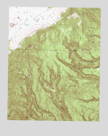
Bland, NM USGS Topographic Map
Click on map above to begin viewing in our Map Viewer.

This topographic map contains these locations and features:
Feature Name Type Latitude Longitude GNIS ID View Map
Alamo SpringSpringN35.8245°W106.4337°915991View Map
Allerton MineMineN35.7500°W106.4661°940109View Map
American SpringSpringN35.8372°W106.3829°918023View Map
Armstead SpringSpringN35.8446°W106.3870°903276View Map
Aspen PeakSummitN35.7545°W106.4978°903451View Map
AvondaleMineN35.7561°W106.4484°916308View Map
Bearhead RidgeRidgeN35.7614°W106.4978°903695View Map
Black GirlMineN35.7525°W106.4661°915633View Map
BlandPopulated PlaceN35.7575°W106.4653°918078View Map
Bland Post Office (historical)Post OfficeN35.7575°W106.4653°938015View Map
Blue Bell MineMineN35.7625°W106.4661°939835View Map
Bruce Place (historical)LocaleN35.7861°W106.4850°918083View Map
Bruce RidgeRidgeN35.7828°W106.4909°918084View Map
Bull of the WoodsMineN35.7589°W106.4650°916305View Map
Caņon del NorteValleyN35.7761°W106.4661°918112View Map
Capulin TrailTrailN35.7714°W106.3925°918124View Map
Cerro GrandeSummitN35.8695°W106.4125°918140View Map
Cerro la JaraSummitN35.8550°W106.4959°918142View Map
Cochiti Chief ClaimMineN35.7656°W106.4745°916266View Map
Cochiti MesaSummitN35.7700°W106.4445°918159View Map
Cochiti Mining DistrictMineN35.7559°W106.4689°918160View Map
Crager RidgeRidgeN35.7936°W106.4709°918163View Map
Crown Point MineMineN35.7670°W106.4720°939647View Map
Crown Point MineMineN35.7717°W106.4664°939651View Map
Daisy MineMineN35.7517°W106.4650°915616View Map
Denver Girl Group MineMineN35.7625°W106.4661°939654View Map
Emerald ClaimMineN35.7625°W106.4734°915496View Map
Empire LodeMineN35.7509°W106.4589°917734View Map
Evans-Griffin Place (historical)LocaleN35.7972°W106.4775°918180View Map
Exchange Hotel Complex Historic SiteBuildingN35.7575°W106.4653°933611View Map
Frazier CanyonValleyN35.7756°W106.4756°918190View Map
Giant ClaimMineN35.7634°W106.4689°916295View Map
Good HopeMineN35.7545°W106.4661°917737View Map
HopewellMineN35.7570°W106.4695°916297View Map
Jaramillo CreekStreamN35.8545°W106.4784°918205View Map
King TutLocaleN35.7717°W106.4664°915630View Map
La Cueva Fire District Cochiti MesaBuildingN35.8275°W106.4677°2657951View Map
La Jara CreekStreamN35.8497°W106.4875°918220View Map
Last Chance LodeMineN35.7706°W106.4720°917699View Map
Last Chance Number TwoMineN35.7517°W106.4695°917700View Map
Laura S. ClaimMineN35.7678°W106.4698°917701View Map
Little CasinoMineN35.7500°W106.4606°917702View Map
Lonestar GroupMineN35.7545°W106.4717°916264View Map
Los Utes SpringSpringN35.7824°W106.4087°899334View Map
Mesa del RitoSummitN35.8036°W106.3817°918253View Map
Missing Link ClaimMineN35.7625°W106.4723°916292View Map
Mogul GroupMineN35.7678°W106.4775°915595View Map
Monte Cristo GroupMineN35.7545°W106.4606°917705View Map
Monument LodeMineN35.7597°W106.4689°917707View Map
North Star LodeMineN35.7561°W106.4706°917722View Map
Obsidian RidgeRidgeN35.8100°W106.4070°918271View Map
Pajarito Canyon TrailTrailN35.8734°W106.3750°915962View Map
Pajarito SpringSpringN35.8403°W106.3809°914290View Map
Paso del NorteGapN35.8250°W106.4789°918285View Map
PinesPopulated PlaceN35.7803°W106.4370°909696View Map
Pines CanyonValleyN35.7820°W106.4378°909697View Map
Pines Post Office (historical)Post OfficeN35.7803°W106.4370°938228View Map
Ponto LodeMineN35.7561°W106.4631°917711View Map
Posey MineMineN35.7500°W106.4661°939648View Map
Rabbit HillSummitN35.7895°W106.3773°918309View Map
Rabbit MountainSummitN35.8320°W106.4714°918310View Map
Reid CanyonValleyN35.7642°W106.4717°910114View Map
SamboMineN35.7553°W106.4673°917077View Map
San Miguel MountainsRangeN35.7645°W106.3803°928805View Map
Sawyer MesaSummitN35.8217°W106.4278°918358View Map
Sawyer SpringSpringN35.8239°W106.3889°914393View Map
Sheridan LodeMineN35.7556°W106.4714°916354View Map
Spruce CanyonValleyN35.7822°W106.4378°911348View Map
Tent RockSummitN35.7856°W106.4389°937202View Map
Tent Rock RanchLocaleN35.7895°W106.4517°911608View Map
Tip Top LodeMineN35.7678°W106.4720°916358View Map
Uncle Joe Number TwoMineN35.7589°W106.4684°916346View Map
Upper Horn MesaSummitN35.7609°W106.4620°918392View Map
Valle Grande Pumice MineMineN35.7970°W106.4636°918394View Map
Valle TrailTrailN35.8609°W106.3842°916082View Map
Washington GroupMineN35.7528°W106.4706°918403View Map
Washington MineMineN35.7525°W106.4711°915627View Map
Woodard RidgeRidgeN35.7717°W106.4961°912487View Map

Note: Coordinates in the location and feature list above are referenced to NAD83 datum.


Copyright (C) 2008-2025 Ryan Niemi / Sunset Dynamics ... All Rights Reserved