TopoQuest Logo
Do you find TopoQuest useful?
Help keep TopoQuest running and adding new maps/features by donating!
Bitcoin:  19c7KJd3qBynnjoSw5npx9KScwjBe4ifkT
Litecoin:  LXs6TkuXGGXo1vDsWCkWVdjQX94eUKd6ui
Home View Maps Find Maps Find Places Resources & Links


Blanding North, Utah Topographic Map

USGS Map Title: Blanding North, UT
USGS Map MRC: 37109F4
DRG (GeoTIFF) Download: o37109f4.tif


Neighboring USGS Topographic Map Quads:


  Mount Linnaeus, UT  
37109G5
 

  Abajo Peak, UT  
37109G4
 

  Monticello South, UT  
37109G3
 

  Mancos Jim Butte, UT  
37109F5
 

  Blanding North, UT  
37109F4
 

  Devil Mesa, UT  
37109F3
 

  Black Mesa Butte, UT  
37109E5
 

  Blanding South, UT  
37109E4
 

  Bradford Canyon, UT  
37109E3


Map MRC Location:

N38°
W110°
N38°
W109°
H8 H7 H6 H5 H4 H3 H2 H1
G8 G7 G6 G5 G4 G3 G2 G1
F8 F7 F6 F5 F4 F3 F2 F1
E8 E7 E6 E5 E4 E3 E2 E1
D8 D7 D6 D5 D4 D3 D2 D1
C8 C7 C6 C5 C4 C3 C2 C1
B8 B7 B6 B5 B4 B3 B2 B1
A8 A7 A6 A5 A4 A3 A2 A1
N37°
W110°
N37°
W109°

Blanding North, UT USGS 1:24K Topographic Map Preview:
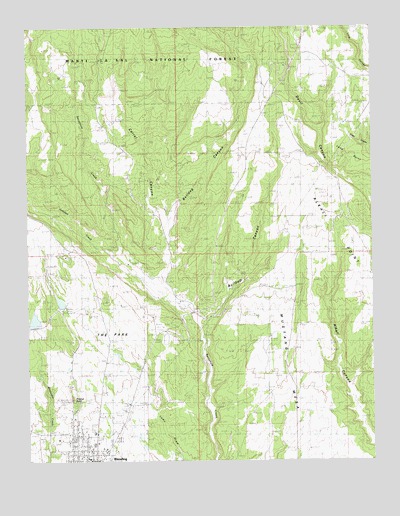
Blanding North, UT USGS Topographic Map
Click on map above to begin viewing in our Map Viewer.

This topographic map contains these locations and features:
Feature Name Type Latitude Longitude GNIS ID View Map
Albert R Lyman Middle SchoolSchoolN37.6329°W109.4774°1448056View Map
Alkali Ridge Historical MarkerParkN37.6806°W109.3779°1448061View Map
Blanding City CemeteryCemeteryN37.6308°W109.4690°1448150View Map
Blanding City Number Four DamDamN37.6639°W109.4973°1447640View Map
Blanding City Number Three DamDamN37.6700°W109.4873°1447642View Map
Blanding City Number Three ReservoirReservoirN37.6707°W109.4887°1447641View Map
Blanding City ReservoirsReservoirN37.6666°W109.4981°1450021View Map
Blanding Police DepartmentBuildingN37.6325°W109.4756°2730343View Map
Blanding Post OfficePost OfficeN37.6266°W109.4778°1455185View Map
Bulldog CanyonValleyN37.6761°W109.4510°1439300View Map
Bullpup CanyonValleyN37.6658°W109.4376°1439312View Map
Carrol CanyonValleyN37.7317°W109.4662°1448229View Map
Devils Canyon CampgroundLocaleN37.7389°W109.4068°1451228View Map
Dry WashValleyN37.6969°W109.4101°1435457View Map
Edge of the Cedars MuseumBuildingN37.6314°W109.4898°1453037View Map
Johnson CreekStreamN37.6831°W109.4657°1442179View Map
KUTA-AM (Blanding)TowerN37.6536°W109.4546°1455727View Map
L-C RanchLocaleN37.6781°W109.4507°1442373View Map
Pinenut KnollSummitN37.6425°W109.4848°1444419View Map
Recapture ReservoirReservoirN37.6687°W109.4429°1448899View Map
San Juan Emergency Medical Services - BlandingBuildingN37.6376°W109.4835°2665440View Map
San Juan High SchoolSchoolN37.6298°W109.4771°1448964View Map
The Church of Jesus Christ of Latter Day SaintsChurchN37.6372°W109.4798°1449350View Map
The Church of Jesus Christ of Latter Day SaintsChurchN37.6286°W109.4737°1449351View Map
The ParkFlatN37.6583°W109.4712°1446486View Map
Water Storage Reservoir Number-FourReservoirN37.6639°W109.4973°1447639View Map

Note: Coordinates in the location and feature list above are referenced to NAD83 datum.


Copyright (C) 2008-2025 Ryan Niemi / Sunset Dynamics ... All Rights Reserved