TopoQuest Logo
Do you find TopoQuest useful?
Help keep TopoQuest running and adding new maps/features by donating!
Bitcoin:  19c7KJd3qBynnjoSw5npx9KScwjBe4ifkT
Litecoin:  LXs6TkuXGGXo1vDsWCkWVdjQX94eUKd6ui
Home View Maps Find Maps Find Places Resources & Links


Sturgill Peak, Idaho Topographic Map

USGS Map Title: Sturgill Peak, ID
USGS Map MRC: 44116E8
DRG (GeoTIFF) Download: o44116e8.tif


Neighboring USGS Topographic Map Quads:


  Sturgill Creek, ID  
44117F1
 

  Neil Gulch, ID  
44116F8
 

  Advent Gulch, ID  
44116F7
 

  Monroe Butte, ID  
44117E1
 

  Sturgill Peak, ID  
44116E8
 

  Hopper Creek, ID  
44116E7
 

  Olds Ferry NE, ID  
44117D1
 

  Mann Creek NW, ID  
44116D8
 

  Midvale Hill, ID  
44116D7


Map MRC Location:

N45°
W117°
N45°
W116°
H8 H7 H6 H5 H4 H3 H2 H1
G8 G7 G6 G5 G4 G3 G2 G1
F8 F7 F6 F5 F4 F3 F2 F1
E8 E7 E6 E5 E4 E3 E2 E1
D8 D7 D6 D5 D4 D3 D2 D1
C8 C7 C6 C5 C4 C3 C2 C1
B8 B7 B6 B5 B4 B3 B2 B1
A8 A7 A6 A5 A4 A3 A2 A1
N44°
W117°
N44°
W116°

Sturgill Peak, ID USGS 1:24K Topographic Map Preview:
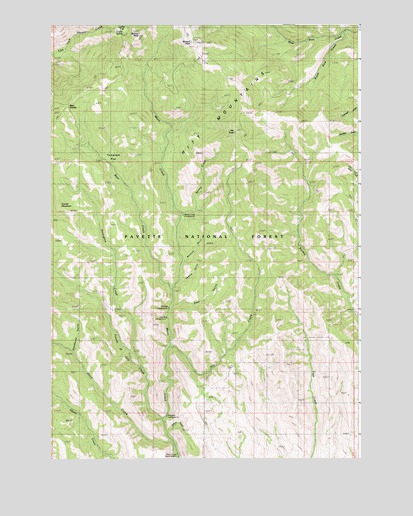
Sturgill Peak, ID USGS Topographic Map
Click on map above to begin viewing in our Map Viewer.

This topographic map contains these locations and features:
Feature Name Type Latitude Longitude GNIS ID View Map
Bear CreekStreamN44.5493°W116.9513°377081View Map
Bear SaddleGapN44.6021°W116.9929°395079View Map
Benton PeakSummitN44.6224°W116.9646°377384View Map
Coffee FlatFlatN44.6241°W116.9699°395233View Map
Coffee SpringSpringN44.6229°W116.9704°395235View Map
Corner MountainSummitN44.5729°W116.9966°379757View Map
Deadhorse GulchValleyN44.5310°W116.9910°380318View Map
Deer GulchValleyN44.5443°W116.9510°380456View Map
Fourth of July CreekStreamN44.5107°W116.9546°381973View Map
Hitt CreekStreamN44.5321°W116.9521°383225View Map
Hitt MountainsRangeN44.5974°W116.8999°393798View Map
Hitt PeakSummitN44.5941°W116.9257°383227View Map
Jeffrey GulchValleyN44.5082°W116.9527°383874View Map
Justrite CampgroundLocaleN44.5407°W116.9532°395543View Map
Kiawanis CampgroundLocaleN44.5127°W116.9532°395550View Map
Mann Creek Guard StationLocaleN44.5007°W116.9493°397890View Map
Mulmick GulchValleyN44.5568°W116.9463°387402View Map
Paradise CampgroundLocaleN44.5435°W116.9527°394892View Map
Porcupine CreekStreamN44.5268°W116.9635°388746View Map
Sawlog GlacierValleyN44.5518°W116.9477°389942View Map
South Pine CreekStreamN44.6221°W116.8816°391073View Map
Spring CreekStreamN44.5696°W116.9471°391162View Map
Spring Creek CampgroundLocaleN44.5702°W116.9468°394469View Map
Stacy CreekStreamN44.5079°W116.9510°391329View Map
Sturgil Peak LookoutLocaleN44.6196°W116.9424°398504View Map
Sturgill PeakSummitN44.6199°W116.9435°391571View Map
Tamarack FlatFlatN44.5877°W116.9746°391831View Map

Note: Coordinates in the location and feature list above are referenced to NAD83 datum.


Copyright (C) 2008-2024 Ryan Niemi / Sunset Dynamics ... All Rights Reserved