TopoQuest Logo
Do you find TopoQuest useful?
Help keep TopoQuest running and adding new maps/features by donating!
Bitcoin:  19c7KJd3qBynnjoSw5npx9KScwjBe4ifkT
Litecoin:  LXs6TkuXGGXo1vDsWCkWVdjQX94eUKd6ui
Home View Maps Find Maps Find Places Resources & Links


Neil Gulch, Idaho Topographic Map

USGS Map Title: Neil Gulch, ID
USGS Map MRC: 44116F8
DRG (GeoTIFF) Download: o44116f8.tif


Neighboring USGS Topographic Map Quads:


  Posy Valley, OR  
44117G1
 

  Brownlee Dam, OR  
44116G8
 

  Cuddy Mountain, ID  
44116G7
 

  Sturgill Creek, ID  
44117F1
 

  Neil Gulch, ID  
44116F8
 

  Advent Gulch, ID  
44116F7
 

  Monroe Butte, ID  
44117E1
 

  Sturgill Peak, ID  
44116E8
 

  Hopper Creek, ID  
44116E7


Map MRC Location:

N45°
W117°
N45°
W116°
H8 H7 H6 H5 H4 H3 H2 H1
G8 G7 G6 G5 G4 G3 G2 G1
F8 F7 F6 F5 F4 F3 F2 F1
E8 E7 E6 E5 E4 E3 E2 E1
D8 D7 D6 D5 D4 D3 D2 D1
C8 C7 C6 C5 C4 C3 C2 C1
B8 B7 B6 B5 B4 B3 B2 B1
A8 A7 A6 A5 A4 A3 A2 A1
N44°
W117°
N44°
W116°

Neil Gulch, ID USGS 1:24K Topographic Map Preview:
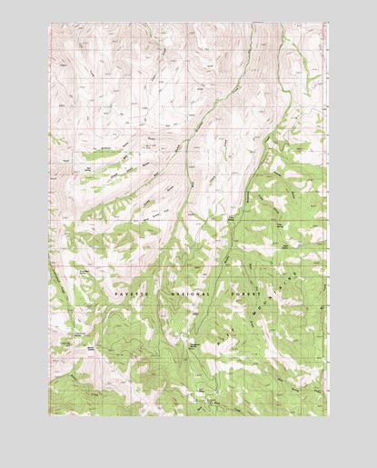
Neil Gulch, ID USGS Topographic Map
Click on map above to begin viewing in our Map Viewer.

This topographic map contains these locations and features:
Feature Name Type Latitude Longitude GNIS ID View Map
Arrowhead SpringSpringN44.6707°W116.9866°395060View Map
Benton SaddleGapN44.6477°W116.9827°395095View Map
Box GulchValleyN44.7127°W116.9416°378153View Map
Box SpringSpringN44.7029°W116.9807°378156View Map
Conner GulchValleyN44.7043°W116.9049°379622View Map
Cottonwood SpringSpringN44.6529°W116.9882°379868View Map
Hit Mountain Ski AreaLocaleN44.6296°W116.9282°394532View Map
Hitt Mountain Ski AreaLocaleN44.6293°W116.9282°395474View Map
Lime SpringSpringN44.6879°W116.9168°384664View Map
Neil Valley GulchValleyN44.7129°W116.9368°387499View Map
Pine Grass FlatFlatN44.6896°W116.9516°388514View Map
Seep SpringSpringN44.6788°W116.8929°395926View Map
Sheep Camp GlacierValleyN44.7043°W116.9488°390175View Map
Sheep GulchValleyN44.7027°W116.9385°390230View Map
Stickney GlacierValleyN44.7138°W116.9604°391457View Map
Telephone SaddleGapN44.6471°W116.9388°399292View Map
Tool CacheSummitN44.6329°W116.9341°397264View Map
Tribe GulchValleyN44.6960°W116.9107°397269View Map
Tribe SpringSpringN44.6854°W116.8985°399326View Map
Wash Pan CreekStreamN44.6788°W116.9168°392913View Map
West Cherry CreekStreamN44.7240°W116.9246°393023View Map

Note: Coordinates in the location and feature list above are referenced to NAD83 datum.


Copyright (C) 2008-2024 Ryan Niemi / Sunset Dynamics ... All Rights Reserved