TopoQuest Logo
Do you find TopoQuest useful?
Help keep TopoQuest running and adding new maps/features by donating!
Bitcoin:  19c7KJd3qBynnjoSw5npx9KScwjBe4ifkT
Litecoin:  LXs6TkuXGGXo1vDsWCkWVdjQX94eUKd6ui
Home View Maps Find Maps Find Places Resources & Links


Catlett, Georgia Topographic Map

USGS Map Title: Catlett, GA
USGS Map MRC: 34085F2
DRG (GeoTIFF) Download: o34085f2.tif


Neighboring USGS Topographic Map Quads:


  Kensington, GA  
34085G3
 

  Nickajack Gap, GA  
34085G2
 

  Tunnel Hill, GA  
34085G1
 

  LaFayette, GA  
34085F3
 

  Catlett, GA  
34085F2
 

  Villanow, GA  
34085F1
 

  Trion, GA  
34085E3
 

  Subligna, GA  
34085E2
 

  Sugar Valley, GA  
34085E1


Map MRC Location:

N35°
W86°
N35°
W85°
H8 H7 H6 H5 H4 H3 H2 H1
G8 G7 G6 G5 G4 G3 G2 G1
F8 F7 F6 F5 F4 F3 F2 F1
E8 E7 E6 E5 E4 E3 E2 E1
D8 D7 D6 D5 D4 D3 D2 D1
C8 C7 C6 C5 C4 C3 C2 C1
B8 B7 B6 B5 B4 B3 B2 B1
A8 A7 A6 A5 A4 A3 A2 A1
N34°
W86°
N34°
W85°

Catlett, GA USGS 1:24K Topographic Map Preview:
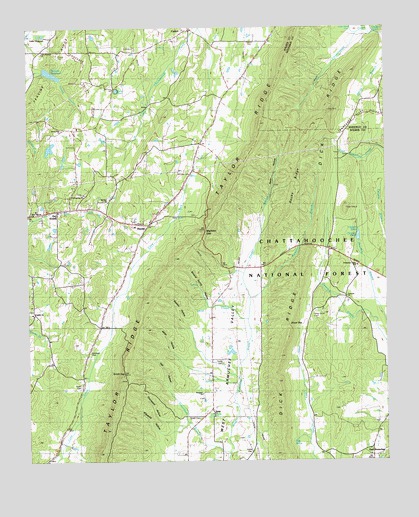
Catlett, GA USGS Topographic Map
Click on map above to begin viewing in our Map Viewer.

This topographic map contains these locations and features:
Feature Name Type Latitude Longitude GNIS ID View Map
Abney LakeReservoirN34.7154°W85.2420°337097View Map
Abney Lake DamDamN34.7151°W85.2416°337096View Map
Armuchee Valley SchoolSchoolN34.6812°W85.1350°330894View Map
Barwick Mill Dam TwoDamN34.7384°W85.2450°337100View Map
Barwick Mills Lake DamDamN34.7384°W85.2450°339607View Map
Barwick ReservoirReservoirN34.7370°W85.2415°330888View Map
Bryan CemeteryCemeteryN34.6470°W85.2316°327246View Map
CatlettPopulated PlaceN34.7495°W85.1925°331345View Map
Catlett First Church of GodChurchN34.7495°W85.1950°353973View Map
Chestnutflat (historical)Populated PlaceN34.7459°W85.1655°353992View Map
Cleghorn SpringSpringN34.6917°W85.1344°327469View Map
Clements PondReservoirN34.6899°W85.1344°327471View Map
Community ChurchChurchN34.7017°W85.2300°354003View Map
Concord Camp Ground (historical)LocaleN34.6726°W85.1391°354004View Map
Concord CemeteryCemeteryN34.6731°W85.1411°354005View Map
Concord ChurchChurchN34.6723°W85.1388°355265View Map
CorinthPopulated PlaceN34.6676°W85.2477°354009View Map
Corinth Baptist ChurchChurchN34.6679°W85.2488°354010View Map
Corinth SchoolSchoolN34.6676°W85.2483°327526View Map
Cornith ChurchChurchN34.6676°W85.2483°330890View Map
Crawford SpringSpringN34.7484°W85.1288°330891View Map
Dick RidgeRidgeN34.6829°W85.1527°355489View Map
Dry Creek SchoolSchoolN34.6981°W85.2391°327696View Map
East ArmucheePopulated PlaceN34.6265°W85.1302°355593View Map
East Armuchee Baptist ChurchChurchN34.6267°W85.1308°354026View Map
East Armuchee CemeteryCemeteryN34.6267°W85.1311°354027View Map
Gladden CemeteryCemeteryN34.7462°W85.1711°327937View Map
Goodram CemeteryCemeteryN34.6567°W85.2288°327964View Map
Gordon Spring CreekStreamN34.7484°W85.1347°327973View Map
Gordon Spring GapGapN34.7442°W85.1577°353426View Map
Greenbush (historical)Populated PlaceN34.6359°W85.1919°354065View Map
Greenbush BranchStreamN34.6273°W85.1800°328003View Map
Hall HollowValleyN34.6459°W85.2008°328040View Map
Hampton BranchStreamN34.6717°W85.1725°326997View Map
Hickory Hill SchoolSchoolN34.6995°W85.2222°328128View Map
Howard Lake SpringSpringN34.7481°W85.2430°354086View Map
Kilpatrick HollowValleyN34.6326°W85.2018°328401View Map
Lake HowardReservoirN34.7481°W85.2455°328241View Map
Lake Howard Baptist ChurchChurchN34.7434°W85.2447°354094View Map
Lake Howard ChurchChurchN34.7431°W85.2444°330889View Map
Maddox GapGapN34.6906°W85.1883°328690View Map
Milan HollowValleyN34.6560°W85.1998°328770View Map
Mineral Spring HollowValleyN34.6707°W85.1870°328814View Map
Mount Zion ChurchChurchN34.7001°W85.2219°328921View Map
NaomiPopulated PlaceN34.6931°W85.2077°332465View Map
Naomi Baptist ChurchChurchN34.6937°W85.2097°354140View Map
Naomi CemeteryCemeteryN34.6931°W85.2049°354141View Map
Naomi Elementary SchoolSchoolN34.6929°W85.2125°354142View Map
New Harvest ChurchChurchN34.6965°W85.2494°330886View Map
Piney Gorve CemeteryCemeteryN34.6662°W85.1505°330893View Map
Piney Grove ChurchChurchN34.6667°W85.1505°329232View Map
Ponder BranchStreamN34.6876°W85.1697°329290View Map
Prospect Baptist ChurchChurchN34.6442°W85.1888°354176View Map
Prospect ChurchChurchN34.6445°W85.1894°330892View Map
Prospect SchoolSchoolN34.6445°W85.1891°329329View Map
Rocky RidgeRidgeN34.7009°W85.1561°330895View Map
Round PondLakeN34.7322°W85.2186°329538View Map
Scott Lake DamDamN34.7373°W85.2438°339609View Map
Shaw GapGapN34.6642°W85.1586°329654View Map
Shiloh CemeteryCemeteryN34.6376°W85.1899°329667View Map
Shiloh CemeteryCemeteryN34.6337°W85.1716°354196View Map
Shiloh ChurchChurchN34.6387°W85.1858°329670View Map
Shop CreekStreamN34.6659°W85.1733°329695View Map
Smith GapGapN34.6504°W85.2166°329738View Map
Sunny Side ChurchChurchN34.7209°W85.2375°330887View Map
Sunnyside ChurchChurchN34.7206°W85.2355°354203View Map
Suttle CemeteryCemeteryN34.6279°W85.1722°329897View Map
Suttles MillPopulated PlaceN34.6251°W85.1833°329899View Map
Tate SpringSpringN34.6306°W85.1575°329938View Map
Thompson HollowValleyN34.6361°W85.1998°329978View Map
Villanow DivisionCivilN34.6498°W85.1331°1936619View Map
Walden HollowValleyN34.6637°W85.1929°330136View Map
Walker County Emergency Services Fire Station 13BuildingN34.6933°W85.2115°2604723View Map
Walker County Emergency Services Fire Station 14BuildingN34.6793°W85.1266°2604726View Map
Walker County Emergency Services Fire Station 17BuildingN34.6303°W85.1949°2604735View Map
West Armuchee SchoolSchoolN34.6298°W85.1933°330209View Map
Whitley CemeteryCemeteryN34.7076°W85.1930°330262View Map
Wood GapGapN34.6870°W85.1513°354233View Map
Woodstation Baptist ChurchChurchN34.7495°W85.1933°354235View Map
Young CemeteryCemeteryN34.6529°W85.1819°330415View Map

Note: Coordinates in the location and feature list above are referenced to NAD83 datum.


Copyright (C) 2008-2024 Ryan Niemi / Sunset Dynamics ... All Rights Reserved