TopoQuest Logo
Do you find TopoQuest useful?
Help keep TopoQuest running and adding new maps/features by donating!
Bitcoin:  19c7KJd3qBynnjoSw5npx9KScwjBe4ifkT
Litecoin:  LXs6TkuXGGXo1vDsWCkWVdjQX94eUKd6ui
Home View Maps Find Maps Find Places Resources & Links


Suggsville, Alabama Topographic Map

USGS Map Title: Suggsville, AL
USGS Map MRC: 31087E6
DRG (GeoTIFF) Download: o31087e6.tif


Neighboring USGS Topographic Map Quads:


  Grove Hill, AL  
31087F7
 

  Whatley, AL  
31087F6
 

  Chance, AL  
31087F5
 

  Walker Springs, AL  
31087E7
 

  Suggsville, AL  
31087E6
 

  Claiborne, AL  
31087E5
 

  Alma, AL  
31087D7
 

  Gainestown, AL  
31087D6
 

  Flynns Lake, AL  
31087D5


Map MRC Location:

N32°
W88°
N32°
W87°
H8 H7 H6 H5 H4 H3 H2 H1
G8 G7 G6 G5 G4 G3 G2 G1
F8 F7 F6 F5 F4 F3 F2 F1
E8 E7 E6 E5 E4 E3 E2 E1
D8 D7 D6 D5 D4 D3 D2 D1
C8 C7 C6 C5 C4 C3 C2 C1
B8 B7 B6 B5 B4 B3 B2 B1
A8 A7 A6 A5 A4 A3 A2 A1
N31°
W88°
N31°
W87°

Suggsville, AL USGS 1:24K Topographic Map Preview:
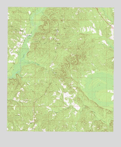
Suggsville, AL USGS Topographic Map
Click on map above to begin viewing in our Map Viewer.

This topographic map contains these locations and features:
Feature Name Type Latitude Longitude GNIS ID View Map
AllenLocaleN31.5965°W87.7278°112993View Map
Allen ChurchChurchN31.5968°W87.7286°163590View Map
Barns Mill BranchStreamN31.5893°W87.7269°113508View Map
Cammack CemeteryCemeteryN31.6038°W87.7289°1766211View Map
Cedar ForkLocaleN31.5585°W87.6958°133596View Map
Cedar Fork CemeteryCemeteryN31.5593°W87.6944°133597View Map
Cedar Fork ChurchChurchN31.5590°W87.6953°115769View Map
Coleman CemeteryCemeteryN31.5943°W87.7478°163601View Map
Dye BranchStreamN31.5793°W87.7372°117709View Map
Fort Glass (historical)MilitaryN31.5219°W87.7189°1700284View Map
Fort Madison (historical)MilitaryN31.5236°W87.7197°1700285View Map
Gillmore Plantation (historical)LocaleN31.5279°W87.6767°1730352View Map
Hearin CemeteryCemeteryN31.6238°W87.6553°1828923View Map
Hickory Hall (historical)LocaleN31.5016°W87.7319°133640View Map
Little Burrough ChurchChurchN31.5157°W87.7356°152087View Map
ManilaPopulated PlaceN31.5085°W87.7231°156651View Map
Mount Horeb ChurchChurchN31.5871°W87.7350°152430View Map
Purrears Chapel (historical)ChurchN31.6057°W87.7453°133689View Map
Puyear ChapelChurchN31.6057°W87.7439°125374View Map
Puyear Chapel CemeteryCemeteryN31.6057°W87.7439°164108View Map
Rock Wall HillSummitN31.5329°W87.6805°1730356View Map
Saint Peters ChurchChurchN31.5827°W87.7439°126197View Map
Skull BranchStreamN31.5940°W87.7264°126942View Map
Smith CreekStreamN31.5699°W87.7350°153474View Map
SuggsvillePopulated PlaceN31.5896°W87.6931°153599View Map
W D Harrigan and Eunice H Woods DamDamN31.6218°W87.6267°129909View Map
W D Harrigan and Eunice Woods LakeReservoirN31.6234°W87.6260°129908View Map
Weighman Chapel African Methodist Episcopal Zion ChurchChurchN31.6015°W87.6928°153097View Map

Note: Coordinates in the location and feature list above are referenced to NAD83 datum.


Copyright (C) 2008-2025 Ryan Niemi / Sunset Dynamics ... All Rights Reserved