TopoQuest Logo
Do you find TopoQuest useful?
Help keep TopoQuest running and adding new maps/features by donating!
Bitcoin:  19c7KJd3qBynnjoSw5npx9KScwjBe4ifkT
Litecoin:  LXs6TkuXGGXo1vDsWCkWVdjQX94eUKd6ui
Home View Maps Find Maps Find Places Resources & Links


Whatley, Alabama Topographic Map

USGS Map Title: Whatley, AL
USGS Map MRC: 31087F6
DRG (GeoTIFF) Download: o31087f6.tif


Neighboring USGS Topographic Map Quads:


  Fulton West, AL  
31087G7
 

  Fulton East, AL  
31087G6
 

  Lower Peach Tree, AL  
31087G5
 

  Grove Hill, AL  
31087F7
 

  Whatley, AL  
31087F6
 

  Chance, AL  
31087F5
 

  Walker Springs, AL  
31087E7
 

  Suggsville, AL  
31087E6
 

  Claiborne, AL  
31087E5


Map MRC Location:

N32°
W88°
N32°
W87°
H8 H7 H6 H5 H4 H3 H2 H1
G8 G7 G6 G5 G4 G3 G2 G1
F8 F7 F6 F5 F4 F3 F2 F1
E8 E7 E6 E5 E4 E3 E2 E1
D8 D7 D6 D5 D4 D3 D2 D1
C8 C7 C6 C5 C4 C3 C2 C1
B8 B7 B6 B5 B4 B3 B2 B1
A8 A7 A6 A5 A4 A3 A2 A1
N31°
W88°
N31°
W87°

Whatley, AL USGS 1:24K Topographic Map Preview:
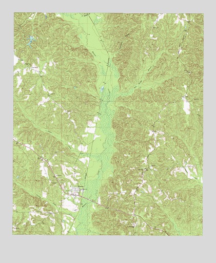
Whatley, AL USGS Topographic Map
Click on map above to begin viewing in our Map Viewer.

This topographic map contains these locations and features:
Feature Name Type Latitude Longitude GNIS ID View Map
Amity Baptist ChurchChurchN31.6643°W87.6592°113062View Map
Amity CemeteryCemeteryN31.6640°W87.6589°1805626View Map
Amity School (historical)SchoolN31.6627°W87.6639°133572View Map
Andrew Jackson Memorial ParkParkN31.6746°W87.6564°143020View Map
Aoh ChurchChurchN31.6377°W87.7247°164020View Map
AsburyPopulated PlaceN31.7007°W87.7239°133574View Map
Asbury ChurchChurchN31.7043°W87.7261°113242View Map
Bethel CemeteryCemeteryN31.6835°W87.6583°163593View Map
Bethel ChurchChurchN31.6838°W87.6583°114044View Map
Bethel Church (historical)ChurchN31.6646°W87.6603°133584View Map
Church of GodChurchN31.6710°W87.7347°163598View Map
Cobbville (historical)LocaleN31.7321°W87.6903°133604View Map
Dacy CemeteryCemeteryN31.6682°W87.7311°117009View Map
Davis CemeteryCemeteryN31.6479°W87.7067°133609View Map
Fishers CreekStreamN31.6340°W87.7069°118317View Map
Fort Sinquefield (historical)MilitaryN31.6604°W87.7283°1680972View Map
Gates CemeteryCemeteryN31.7404°W87.6361°118870View Map
Graveyard BranchStreamN31.7204°W87.6869°119278View Map
Grove Hill DivisionCivilN31.6348°W87.6997°161602View Map
Hill CemeteryCemeteryN31.6546°W87.7214°120091View Map
Horeb Baptist ChurchChurchN31.6507°W87.7111°133643View Map
Indian Ridge CemeteryCemeteryN31.6618°W87.6630°1729933View Map
Indian Ridge ChurchChurchN31.6621°W87.6633°151854View Map
Indian Ridge Church (historical)ChurchN31.6327°W87.6681°133645View Map
James CreekStreamN31.6699°W87.6925°120810View Map
Lake HarringanReservoirN31.7344°W87.7389°129942View Map
Little Bassett CreekStreamN31.7479°W87.7061°121688View Map
Moncrief School House (historical)SchoolN31.7035°W87.7261°133675View Map
Morning Star Baptist ChurchChurchN31.6302°W87.6700°152379View Map
Orange HillSummitN31.7196°W87.7414°124300View Map
Orange Hill Baptist ChurchChurchN31.7190°W87.7383°152818View Map
Orange Hill SchoolSchoolN31.7177°W87.7375°163127View Map
Pole Bridge BranchStreamN31.7077°W87.6714°125088View Map
Pouncey (historical)LocaleN31.6668°W87.6925°133688View Map
Salem CemeteryCemeteryN31.7421°W87.6592°164121View Map
Spinks CemeteryCemeteryN31.7204°W87.7403°127188View Map
Spinks Chapel (historical)ChurchN31.7193°W87.7400°133713View Map
VashtiPopulated PlaceN31.7032°W87.6381°157196View Map
W D Harrigan DamDamN31.7368°W87.7383°129943View Map
WhatleyPopulated PlaceN31.6507°W87.7050°153954View Map
Whatley CemeteryCemeteryN31.6479°W87.7069°154557View Map
Whatley Census Designated PlaceCensusN31.6463°W87.7108°2628609View Map
Whatley First Assembly of God ChurchChurchN31.6477°W87.7072°154558View Map
Whatley Post OfficePost OfficeN31.6507°W87.7060°2789083View Map

Note: Coordinates in the location and feature list above are referenced to NAD83 datum.


Copyright (C) 2008-2025 Ryan Niemi / Sunset Dynamics ... All Rights Reserved