TopoQuest Logo
Do you find TopoQuest useful?
Help keep TopoQuest running and adding new maps/features by donating!
Bitcoin:  19c7KJd3qBynnjoSw5npx9KScwjBe4ifkT
Litecoin:  LXs6TkuXGGXo1vDsWCkWVdjQX94eUKd6ui
Home View Maps Find Maps Find Places Resources & Links


Sullivan Gulch, Oregon Topographic Map

USGS Map Title: Sullivan Gulch, OR
USGS Map MRC: 45118B5
DRG (GeoTIFF) Download: o45118b5.tif


Neighboring USGS Topographic Map Quads:


  Tamarack Gulch, OR  
45118C6
 

  Bally Mountain, OR  
45118C5
 

  McIntyre Creek, OR  
45118C4
 

  Lehman Springs, OR  
45118B6
 

  Sullivan Gulch, OR  
45118B5
 

  Marley Creek, OR  
45118B4
 

  Pearson Ridge, OR  
45118A6
 

  Tower Mountain, OR  
45118A5
 

  Fly Valley, OR  
45118A4


Map MRC Location:

N46°
W119°
N46°
W118°
H8 H7 H6 H5 H4 H3 H2 H1
G8 G7 G6 G5 G4 G3 G2 G1
F8 F7 F6 F5 F4 F3 F2 F1
E8 E7 E6 E5 E4 E3 E2 E1
D8 D7 D6 D5 D4 D3 D2 D1
C8 C7 C6 C5 C4 C3 C2 C1
B8 B7 B6 B5 B4 B3 B2 B1
A8 A7 A6 A5 A4 A3 A2 A1
N45°
W119°
N45°
W118°

Sullivan Gulch, OR USGS 1:24K Topographic Map Preview:
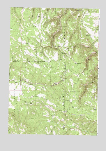
Sullivan Gulch, OR USGS Topographic Map
Click on map above to begin viewing in our Map Viewer.

This topographic map contains these locations and features:
Feature Name Type Latitude Longitude GNIS ID View Map
A P SpringSpringN45.1392°W118.5009°1116748View Map
Bear SpringSpringN45.2108°W118.5420°1137750View Map
Blarney SpringSpringN45.1560°W118.5955°1138254View Map
Camas Creek CorralLocaleN45.1774°W118.6066°1162308View Map
Camas SpringSpringN45.1787°W118.5522°1139179View Map
Campbell SpringSpringN45.2298°W118.5055°1139288View Map
Doherty SpringSpringN45.1514°W118.5060°1141153View Map
Flat Rock SpringSpringN45.1530°W118.5363°1142242View Map
Four Corners Recreation SiteLocaleN45.1785°W118.6069°1142357View Map
Frog Heaven MeadowFlatN45.2146°W118.5989°1142496View Map
Frog Heaven Recreation SiteLocaleN45.2132°W118.6039°1952983View Map
Half Moon SpringSpringN45.2314°W118.5932°1143206View Map
Kaenta SpringSpringN45.1957°W118.5317°1144475View Map
Little Bear CreekStreamN45.2485°W118.5255°1145086View Map
Lower Bluff SpringsSpringN45.2058°W118.5522°1145604View Map
Mud Hole SpringSpringN45.1493°W118.5501°1146568View Map
Mud SpringSpringN45.1935°W118.5419°1153935View Map
Mud SpringSpringN45.1940°W118.5408°1153019View Map
Only Entry PointLocaleN45.2099°W118.5016°1156095View Map
Pe’ískit CreekStreamN45.1337°W118.5366°1150258View Map
Perrin SpringSpringN45.2058°W118.5799°1147598View Map
Red Fir SpringSpringN45.1967°W118.5832°1148294View Map
Research CorralsLocaleN45.2415°W118.5077°1156094View Map
Sardine SpringSpringN45.2087°W118.5877°1149074View Map
Starkey Experimental ForestForestN45.2332°W118.5511°1150349View Map
Starkey Experimental Forest HeadquartersLocaleN45.2240°W118.5138°1141941View Map
Sullivan SpringSpringN45.1995°W118.5163°1150574View Map
Tamarack SpringSpringN45.2317°W118.5456°1150874View Map
Tin Troughs SpringSpringN45.1588°W118.5412°1151263View Map
Umapine CreekStreamN45.1362°W118.5561°1151634View Map
Upper Bluff SpringSpringN45.1994°W118.5547°1151664View Map

Note: Coordinates in the location and feature list above are referenced to NAD83 datum.


Copyright (C) 2008-2024 Ryan Niemi / Sunset Dynamics ... All Rights Reserved