TopoQuest Logo
Do you find TopoQuest useful?
Help keep TopoQuest running and adding new maps/features by donating!
Bitcoin:  19c7KJd3qBynnjoSw5npx9KScwjBe4ifkT
Litecoin:  LXs6TkuXGGXo1vDsWCkWVdjQX94eUKd6ui
Home View Maps Find Maps Find Places Resources & Links


Sulphur Springs SE, Texas Topographic Map

USGS Map Title: Sulphur Springs SE, TX
USGS Map MRC: 33095A5
DRG (GeoTIFF) Download: o33095a5.tif


Neighboring USGS Topographic Map Quads:


  Gafford Chapel, TX  
33095B6
 

  Sulphur Springs, TX  
33095B5
 

  Dike, TX  
33095B4
 

  Brashear, TX  
33095A6
 

  Sulphur Springs SE, TX  
33095A5
 

  Como, TX  
33095A4
 

  Arbala, TX  
32095H6
 

  Yantis, TX  
32095H5
 

  Pleasant Grove, TX  
32095H4


Map MRC Location:

N34°
W96°
N34°
W95°
H8 H7 H6 H5 H4 H3 H2 H1
G8 G7 G6 G5 G4 G3 G2 G1
F8 F7 F6 F5 F4 F3 F2 F1
E8 E7 E6 E5 E4 E3 E2 E1
D8 D7 D6 D5 D4 D3 D2 D1
C8 C7 C6 C5 C4 C3 C2 C1
B8 B7 B6 B5 B4 B3 B2 B1
A8 A7 A6 A5 A4 A3 A2 A1
N33°
W96°
N33°
W95°

Sulphur Springs SE, TX USGS 1:24K Topographic Map Preview:
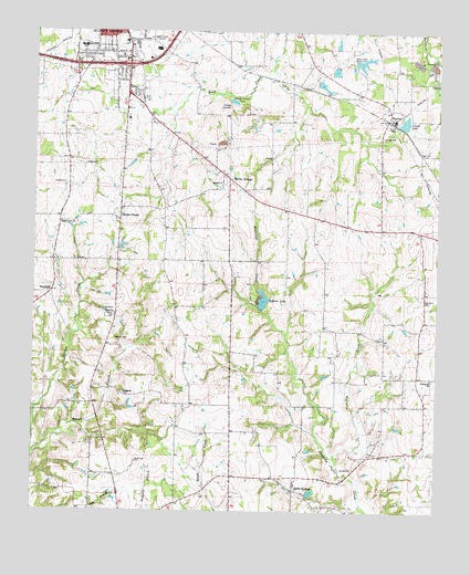
Sulphur Springs SE, TX USGS Topographic Map
Click on map above to begin viewing in our Map Viewer.

This topographic map contains these locations and features:
Feature Name Type Latitude Longitude GNIS ID View Map
Alberta LakeReservoirN33.0550°W95.5541°1329331View Map
Berry LakeReservoirN33.1170°W95.5245°1855517View Map
Berry Lake DamDamN33.1168°W95.5269°1855516View Map
Bowie Elementary SchoolSchoolN33.1115°W95.5925°2006307View Map
Church of ChristChurchN33.1209°W95.6127°2020906View Map
Church of ChristChurchN33.1157°W95.5975°2020907View Map
Crush LakeReservoirN33.1020°W95.5104°1333755View Map
Crush Lake DamDamN33.1001°W95.5119°1855518View Map
Dry CreekStreamN33.0112°W95.5300°1334666View Map
Elberta Lake DamDamN33.0535°W95.5552°1855512View Map
Gamblin CemeteryCemeteryN33.0551°W95.5047°1336359View Map
GreenpondPopulated PlaceN33.0348°W95.5030°2034636View Map
Greenpond ChurchChurchN33.0348°W95.5025°1336972View Map
Hopkins County Fire Deparment Central StationBuildingN33.1123°W95.6113°2655391View Map
Jennings LakeReservoirN33.0954°W95.5878°1864787View Map
Jennings Lake DamDamN33.0968°W95.5869°1864786View Map
KSST-AM (Sulphur Springs)TowerN33.1168°W95.5850°1385699View Map
Martin SpringsPopulated PlaceN33.0868°W95.5650°1378646View Map
Melton CemeteryCemeteryN33.0451°W95.6000°1341356View Map
Olive Branch Baptist ChurchChurchN33.1182°W95.5997°2020903View Map
Our Savior Lutheran ChurchChurchN33.1215°W95.6066°2020910View Map
Reilly SpringsPopulated PlaceN33.0060°W95.5452°1345027View Map
Restlawn Memorial CemeteryCemeteryN33.0521°W95.6016°1345106View Map
Seymore DivisionCivilN33.0139°W95.5965°1939187View Map
Shady Grove ChurchChurchN33.0751°W95.6169°1346947View Map
Shooks ChapelLocaleN33.0759°W95.5988°1347089View Map
Steward Lake DamDamN33.1118°W95.5386°1855514View Map
Stewart LakeReservoirN33.1115°W95.5391°1855515View Map
Sulphur Springs Fire Department Station 2BuildingN33.1224°W95.5963°2655268View Map
Sulphur Springs Middle SchoolSchoolN33.1221°W95.6111°2006283View Map
TazewellPopulated PlaceN33.0568°W95.6200°1379140View Map
ThermoPopulated PlaceN33.1023°W95.5161°1379154View Map
UnionPopulated PlaceN33.0307°W95.5969°2034630View Map
Union ChurchChurchN33.0304°W95.5966°1349057View Map

Note: Coordinates in the location and feature list above are referenced to NAD83 datum.


Copyright (C) 2008-2025 Ryan Niemi / Sunset Dynamics ... All Rights Reserved