TopoQuest Logo
Do you find TopoQuest useful?
Help keep TopoQuest running and adding new maps/features by donating!
Bitcoin:  19c7KJd3qBynnjoSw5npx9KScwjBe4ifkT
Litecoin:  LXs6TkuXGGXo1vDsWCkWVdjQX94eUKd6ui
Home View Maps Find Maps Find Places Resources & Links


Yantis, Texas Topographic Map

USGS Map Title: Yantis, TX
USGS Map MRC: 32095H5
DRG (GeoTIFF) Download: o32095h5.tif


Neighboring USGS Topographic Map Quads:


  Brashear, TX  
33095A6
 

  Sulphur Springs SE, TX  
33095A5
 

  Como, TX  
33095A4
 

  Arbala, TX  
32095H6
 

  Yantis, TX  
32095H5
 

  Pleasant Grove, TX  
32095H4
 

  Alba, TX  
32095G6
 

  Calvary, TX  
32095G5
 

  Quitman, TX  
32095G4


Map MRC Location:

N33°
W96°
N33°
W95°
H8 H7 H6 H5 H4 H3 H2 H1
G8 G7 G6 G5 G4 G3 G2 G1
F8 F7 F6 F5 F4 F3 F2 F1
E8 E7 E6 E5 E4 E3 E2 E1
D8 D7 D6 D5 D4 D3 D2 D1
C8 C7 C6 C5 C4 C3 C2 C1
B8 B7 B6 B5 B4 B3 B2 B1
A8 A7 A6 A5 A4 A3 A2 A1
N32°
W96°
N32°
W95°

Yantis, TX USGS 1:24K Topographic Map Preview:
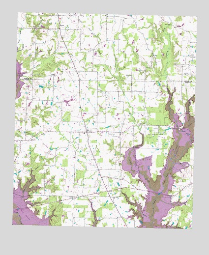
Yantis, TX USGS Topographic Map
Click on map above to begin viewing in our Map Viewer.

This topographic map contains these locations and features:
Feature Name Type Latitude Longitude GNIS ID View Map
Board BranchStreamN32.9504°W95.5038°1330960View Map
Brushy BranchStreamN32.9773°W95.6244°1331413View Map
Cane BranchStreamN32.9904°W95.6219°1332062View Map
Carroll CreekStreamN32.9321°W95.5111°1372139View Map
County Line ChurchChurchN32.9362°W95.5388°1333513View Map
CrossroadsPopulated PlaceN32.9910°W95.5958°2034779View Map
GamblinPopulated PlaceN32.8915°W95.5830°1378341View Map
GilbrethPopulated PlaceN32.8962°W95.5597°1378354View Map
Glade CreekStreamN32.8968°W95.5255°1336553View Map
GrubbePopulated PlaceN32.9635°W95.5994°1378392View Map
Holland CemeteryCemeteryN32.8943°W95.6122°1337944View Map
Independent ChurchChurchN32.9715°W95.5102°1338391View Map
Long BranchStreamN32.8754°W95.5280°1340427View Map
Marlin's Meadow AirportAirportN32.9510°W95.5799°1387774View Map
Midway ChurchChurchN32.9646°W95.5450°1341566View Map
Oak Valley ChurchChurchN32.8923°W95.5558°1343007View Map
Reppond BranchStreamN32.9868°W95.5686°1345046View Map
Running CreekStreamN32.9057°W95.5200°1345749View Map
Sandifer SchoolSchoolN32.9665°W95.5080°1346569View Map
Sartin BluffCliffN32.9912°W95.6136°1346712View Map
SeymorePopulated PlaceN32.9910°W95.5955°1379058View Map
Seymore CemeteryCemeteryN32.9857°W95.5950°1346921View Map
Sharp CemeteryCemeteryN32.9123°W95.5527°1346978View Map
Sulphur Springs Public LibraryBuildingN32.9593°W95.6027°2014781View Map
Town of YantisCivilN32.9305°W95.5761°2413519View Map
White Oak ChurchChurchN32.9251°W95.6144°1349962View Map
YantisPopulated PlaceN32.9304°W95.5750°1350640View Map
Yantis CemeteryCemeteryN32.9365°W95.5686°1350641View Map
Yantis City HallBuildingN32.9308°W95.5748°2753767View Map
Yantis Gas and Oil FieldOilfieldN32.9318°W95.5275°1350642View Map
Yantis Post OfficePost OfficeN32.9341°W95.5757°2732025View Map
Yantis Volunteer Fire DepartmentBuildingN32.9333°W95.5762°2655220View Map

Note: Coordinates in the location and feature list above are referenced to NAD83 datum.


Copyright (C) 2008-2025 Ryan Niemi / Sunset Dynamics ... All Rights Reserved