TopoQuest Logo
Do you find TopoQuest useful?
Help keep TopoQuest running and adding new maps/features by donating!
Bitcoin:  19c7KJd3qBynnjoSw5npx9KScwjBe4ifkT
Litecoin:  LXs6TkuXGGXo1vDsWCkWVdjQX94eUKd6ui
Home View Maps Find Maps Find Places Resources & Links


Sumner, Iowa Topographic Map

USGS Map Title: Sumner, IA
USGS Map MRC: 42092G1
DRG (GeoTIFF) Download: o42092g1.tif


Neighboring USGS Topographic Map Quads:


  Fredericksburg, IA  
42092H2
 

  Alpha, IA  
42092H1
 

  Hawkeye, IA  
42091H8
 

  Sumner SW, IA  
42092G2
 

  Sumner, IA  
42092G1
 

  Maynard, IA  
42091G8
 

  Readlyn, IA  
42092F2
 

  Fairbank, IA  
42092F1
 

  Oelwein, IA  
42091F8


Map MRC Location:

N43°
W93°
N43°
W92°
H8 H7 H6 H5 H4 H3 H2 H1
G8 G7 G6 G5 G4 G3 G2 G1
F8 F7 F6 F5 F4 F3 F2 F1
E8 E7 E6 E5 E4 E3 E2 E1
D8 D7 D6 D5 D4 D3 D2 D1
C8 C7 C6 C5 C4 C3 C2 C1
B8 B7 B6 B5 B4 B3 B2 B1
A8 A7 A6 A5 A4 A3 A2 A1
N42°
W93°
N42°
W92°

Sumner, IA USGS 1:24K Topographic Map Preview:
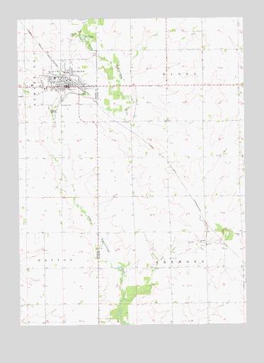
Sumner, IA USGS Topographic Map
Click on map above to begin viewing in our Map Viewer.

This topographic map contains these locations and features:
Feature Name Type Latitude Longitude GNIS ID View Map
Bauer Chiropractic ClinicHospitalN42.8475°W92.0971°1948395View Map
City of SumnerCivilN42.8495°W92.0974°468764View Map
Community Memorial HospitalHospitalN42.8463°W92.1091°1948400View Map
Cub ParkParkN42.8455°W92.0988°1948412View Map
Durant Elementary SchoolSchoolN42.8511°W92.1048°1948409View Map
Faith Evangelical ChurchChurchN42.8569°W92.0985°1948406View Map
First Baptist ChurchChurchN42.8486°W92.0946°1948402View Map
Fredericksburg Farmers Cooperative ElevatorLocaleN42.8472°W92.1210°1948392View Map
Greenwood CemeteryCemeteryN42.7769°W92.0424°1945190View Map
Haw Dental ClinicHospitalN42.8475°W92.0971°1948398View Map
Immaculate Conception ChurchChurchN42.8478°W92.1024°1948405View Map
Koeberle ParkParkN42.8491°W92.1018°1948414View Map
Mary Winks ParkParkN42.8478°W92.0905°1948411View Map
Meadowbrook Country ClubLocaleN42.8541°W92.1057°1948416View Map
Mill Post Office (historical)Post OfficeN42.7728°W92.0230°466480View Map
Mount Calvary CemeteryCemeteryN42.8402°W92.1021°459281View Map
Murphy ChurchChurchN42.7766°W92.0421°459406View Map
North Woods County ParkParkN42.8675°W92.0866°459648View Map
Saint John CemeteryCemeteryN42.8685°W92.0957°460995View Map
Saint John Lutheran ChurchChurchN42.8478°W92.0935°1948401View Map
Saint Pauls Lutheran ChurchChurchN42.8497°W92.1049°1948404View Map
Saint Peter CemeteryCemeteryN42.7863°W92.0028°461312View Map
Stoe CreekStreamN42.7605°W92.0674°462003View Map
SumnerPopulated PlaceN42.8475°W92.0916°462083View Map
Sumner - Fredericksburg High SchoolSchoolN42.8531°W92.1074°1948408View Map
Sumner (historical)LocaleN42.8500°W92.0946°1948393View Map
Sumner BridgeBridgeN42.8622°W92.0746°1945203View Map
Sumner City ParkParkN42.8444°W92.0877°1948410View Map
Sumner Emergency Medical Services IncorporatedBuildingN42.8472°W92.1086°2599784View Map
Sumner Fire DepartmentBuildingN42.8478°W92.0961°2371668View Map
Sumner Junior High SchoolSchoolN42.8508°W92.1007°1948407View Map
Sumner Medical ClinicHospitalN42.8469°W92.1093°1948399View Map
Sumner Police DepartmentBuildingN42.8473°W92.0974°1948396View Map
Sumner Post OfficePost OfficeN42.8466°W92.0980°1948397View Map
Sumner Public LibraryBuildingN42.8478°W92.0960°1948394View Map
Township of BanksCivilN42.8626°W92.0226°467412View Map
Township of FremontCivilN42.7738°W92.0222°467878View Map
Union Mound CemeteryCemeteryN42.8508°W92.1099°462459View Map
United Methodist ChurchChurchN42.8480°W92.0949°1948403View Map
Water Tower ParkParkN42.8494°W92.0985°1948413View Map
Wilsons Creek (historical)LocaleN42.8569°W92.0688°466300View Map

Note: Coordinates in the location and feature list above are referenced to NAD83 datum.


Copyright (C) 2008-2024 Ryan Niemi / Sunset Dynamics ... All Rights Reserved