TopoQuest Logo
Do you find TopoQuest useful?
Help keep TopoQuest running and adding new maps/features by donating!
Bitcoin:  19c7KJd3qBynnjoSw5npx9KScwjBe4ifkT
Litecoin:  LXs6TkuXGGXo1vDsWCkWVdjQX94eUKd6ui
Home View Maps Find Maps Find Places Resources & Links


Surf, California Topographic Map

USGS Map Title: Surf, CA
USGS Map MRC: 34120F5
DRG (GeoTIFF) Download: o34120f5.tif


Neighboring USGS Topographic Map Quads:


  Casmalia, CA  
34120G5
 

  Orcutt, CA  
34120G4


  Surf, CA  
34120F5
 

  Lompoc, CA  
34120F4
 

  Point Arguello, CA  
34120E6
 

  Tranquillon Mountain, CA  
34120E5
 

  Lompoc Hills, CA  
34120E4


Map MRC Location:

N35°
W121°
N35°
W120°
H8 H7 H6 H5 H4 H3 H2 H1
G8 G7 G6 G5 G4 G3 G2 G1
F8 F7 F6 F5 F4 F3 F2 F1
E8 E7 E6 E5 E4 E3 E2 E1
D8 D7 D6 D5 D4 D3 D2 D1
C8 C7 C6 C5 C4 C3 C2 C1
B8 B7 B6 B5 B4 B3 B2 B1
A8 A7 A6 A5 A4 A3 A2 A1
N34°
W121°
N34°
W120°

Surf, CA USGS 1:24K Topographic Map Preview:
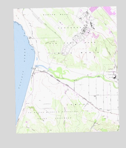
Surf, CA USGS Topographic Map
Click on map above to begin viewing in our Map Viewer.

This topographic map contains these locations and features:
Feature Name Type Latitude Longitude GNIS ID View Map
Artesia SchoolSchoolN34.6611°W120.5282°238785View Map
BarodaPopulated PlaceN34.6866°W120.5927°252848View Map
Bear CreekStreamN34.6478°W120.6016°239091View Map
Burton MesaSummitN34.7408°W120.5368°1660396View Map
Caņada TortugaValleyN34.7119°W120.5982°240191View Map
KNEZ-AM (Lompoc)TowerN34.6464°W120.5110°1662645View Map
La SallePopulated PlaceN34.6478°W120.5263°252917View Map
La Salle CanyonValleyN34.6416°W120.5252°244455View Map
La Salle StablesLocaleN34.6394°W120.5294°2703685View Map
Lake CanyonValleyN34.7069°W120.5010°244522View Map
Lompoc CanyonValleyN34.6691°W120.5629°245031View Map
Lompoc LandingLocaleN34.7200°W120.6079°1660938View Map
Lompoc TerraceBenchN34.6516°W120.5877°245033View Map
Manzanita Public Charter SchoolSchoolN34.7476°W120.5070°1871722View Map
Maple High SchoolSchoolN34.7453°W120.5027°1871723View Map
Oak CanyonValleyN34.6808°W120.5260°246712View Map
Ocean Beach ParkParkN34.6897°W120.6018°246801View Map
Pine CanyonValleyN34.6928°W120.5052°247482View Map
PostLocaleN34.6544°W120.5368°247722View Map
Santa Lucia CanyonValleyN34.6797°W120.5188°249073View Map
Santa Ynez RiverStreamN34.6919°W120.6018°249134View Map
Sloans CanyonValleyN34.6361°W120.5038°249573View Map
Spring CanyonValleyN34.6314°W120.6182°249818View Map
SurfPopulated PlaceN34.6844°W120.6035°250152View Map
United States Penitentiary LompocBuildingN34.6780°W120.5055°2739939View Map
Vandenberg Air Force BaseAirportN34.7332°W120.5700°2650983View Map
Vandenberg Air Force Base Census Designated PlaceCensusN34.7483°W120.5182°2409501View Map
Vandenberg Air Force Base Fire Department Station 1BuildingN34.7342°W120.5690°2664752View Map
Vandenberg Air Force Base Fire Department Station 5BuildingN34.6484°W120.6130°2664827View Map
Vandenberg Air Force Base Post OfficePost OfficeN34.7351°W120.5385°2783781View Map
Vandenberg Fire DepartmentBuildingN34.7197°W120.5356°2664754View Map
Weser Spur (historical)LocaleN34.6616°W120.6104°1702902View Map

Note: Coordinates in the location and feature list above are referenced to NAD83 datum.


Copyright (C) 2008-2025 Ryan Niemi / Sunset Dynamics ... All Rights Reserved