TopoQuest Logo
Do you find TopoQuest useful?
Help keep TopoQuest running and adding new maps/features by donating!
Bitcoin:  19c7KJd3qBynnjoSw5npx9KScwjBe4ifkT
Litecoin:  LXs6TkuXGGXo1vDsWCkWVdjQX94eUKd6ui
Home View Maps Find Maps Find Places Resources & Links


Swansea, South Carolina Topographic Map

USGS Map Title: Swansea, SC
USGS Map MRC: 33081F1
DRG (GeoTIFF) Download: o33081f1.tif


Neighboring USGS Topographic Map Quads:


  Pelion East, SC  
33081G2
 

  Gaston, SC  
33081G1
 

  Saylors Lake, SC  
33080G8
 

  Pond Branch, SC  
33081F2
 

  Swansea, SC  
33081F1
 

  Staley Crossroads, SC  
33080F8
 

  Harleys Millpond, SC  
33081E2
 

  North, SC  
33081E1
 

  Wolfton, SC  
33080E8


Map MRC Location:

N34°
W82°
N34°
W81°
H8 H7 H6 H5 H4 H3 H2 H1
G8 G7 G6 G5 G4 G3 G2 G1
F8 F7 F6 F5 F4 F3 F2 F1
E8 E7 E6 E5 E4 E3 E2 E1
D8 D7 D6 D5 D4 D3 D2 D1
C8 C7 C6 C5 C4 C3 C2 C1
B8 B7 B6 B5 B4 B3 B2 B1
A8 A7 A6 A5 A4 A3 A2 A1
N33°
W82°
N33°
W81°

Swansea, SC USGS 1:24K Topographic Map Preview:
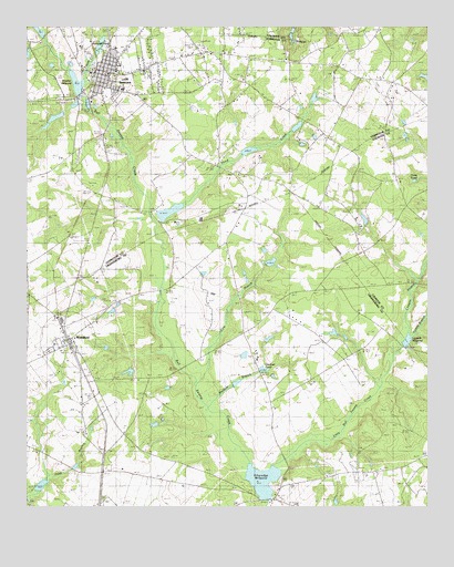
Swansea, SC USGS Topographic Map
Click on map above to begin viewing in our Map Viewer.

This topographic map contains these locations and features:
Feature Name Type Latitude Longitude GNIS ID View Map
Brooker MillpondReservoirN33.7354°W81.1093°1237749View Map
Bull Swamp Baptist ChurchChurchN33.6296°W81.0462°1247058View Map
Calvary Methodist ChurchChurchN33.7382°W81.0290°1244112View Map
Calvary SchoolSchoolN33.7404°W81.0293°1221228View Map
Canaan United Methodist Church CemeteryCemeteryN33.6330°W81.0309°2681194View Map
Cannon ChurchChurchN33.6329°W81.0306°1247148View Map
Cow BranchStreamN33.6596°W81.0712°1221785View Map
Cowpen SwampStreamN33.6721°W81.0062°1221799View Map
Davis PondReservoirN33.7107°W81.0012°1221938View Map
Dixie SchoolSchoolN33.7127°W81.0565°1222037View Map
Ebenezer SchoolSchoolN33.6596°W81.0423°1222225View Map
Etheredge MillpondReservoirN33.6320°W81.0512°1247687View Map
Etheridge Mill (historical)LocaleN33.6268°W81.0484°1242612View Map
Fourth CreekStreamN33.7354°W81.1054°1222521View Map
Fridays PondReservoirN33.6308°W81.1202°1238172View Map
Gardner BranchStreamN33.6504°W81.0673°1222646View Map
Gardner PondReservoirN33.6610°W81.0510°1222647View Map
Gethesame School (historical)SchoolN33.6915°W81.0793°1242635View Map
Gethsemane ChurchChurchN33.6774°W81.0187°1222686View Map
Gissendanner BridgeBridgeN33.6815°W81.0818°1222713View Map
Granger Pond Dam D-3680DamN33.6902°W81.0465°1240300View Map
Gunter PondReservoirN33.7168°W81.0832°1237725View Map
Hoffman Pond Dam D-3681DamN33.6868°W81.0698°1240301View Map
Ingletts Pond Dam D-3686DamN33.6602°W81.0915°1240304View Map
Jumper Station Fire DepartmentBuildingN33.7017°W81.0244°2578539View Map
Knotts PondReservoirN33.6738°W81.0612°1223763View Map
Layseth MillpondReservoirN33.6684°W81.0062°1224222View Map
Layseth Millpond Dam D-2923DamN33.6674°W81.0070°1239612View Map
Lexington County Fire Service SwanseaBuildingN33.7368°W81.1037°2578212View Map
Little Bull Swamp CreekStreamN33.6327°W81.0498°1246391View Map
Midway MillpondReservoirN33.6621°W81.0765°1246647View Map
Monroe Pinkney Middle SchoolSchoolN33.7390°W81.0970°1244277View Map
North DivisionCivilN33.6280°W81.0525°1938366View Map
North Fire Department Station 2BuildingN33.6594°W81.0818°2578231View Map
Penn Branch Baptist Church CemeteryCemeteryN33.6442°W81.1066°2681234View Map
Penn Branch ChurchChurchN33.6443°W81.1054°1225359View Map
Persimmon BranchStreamN33.6554°W81.0154°1225377View Map
Railroad PondReservoirN33.7440°W81.1018°1225739View Map
Redmond PondLakeN33.7135°W81.0632°1225797View Map
Redmons Mill (historical)LocaleN33.7165°W81.0576°1244335View Map
Sardis ChurchChurchN33.7438°W81.0426°1250788View Map
Shannon PondReservoirN33.7001°W81.0195°1239629View Map
Shannon Pond Dam D-2673DamN33.6985°W81.0198°1239628View Map
Sharpes PondReservoirN33.7497°W81.1219°1237831View Map
Shulls Pond Dam D-3685DamN33.6602°W81.0532°1240302View Map
South Carolina Noname 32005 D-1710 DamDamN33.7168°W81.0832°1237724View Map
South Carolina Noname 32020 D-0982 DamDamN33.7352°W81.1115°1237748View Map
South Carolina Noname 32093 D-1008 DamDamN33.7168°W81.0565°1239221View Map
South Carolina Noname 32094 D-1009 DamDamN33.7302°W81.0365°1239220View Map
South Carolina Noname 38004 D-3684 DamDamN33.6268°W81.0501°1238101View Map
South Carolina Noname 38067 D-3683 DamDamN33.6302°W81.1215°1238171View Map
SwanseaPopulated PlaceN33.7382°W81.0979°1231848View Map
Swansea Elementary SchoolSchoolN33.7449°W81.1079°1244402View Map
Swansea High SchoolSchoolN33.7365°W81.0940°1244404View Map
Swansea Junior High SchoolSchoolN33.7340°W81.0923°1251085View Map
Swansea Post OfficePost OfficeN33.7366°W81.1001°2489894View Map
Swansea School (historical)SchoolN33.7324°W81.0907°1244405View Map
Third CreekStreamN33.6979°W81.0829°1227092View Map
Town of SwanseaCivilN33.7397°W81.1052°2406701View Map
Town of WoodfordCivilN33.6687°W81.1120°2406910View Map
Trinity ChurchChurchN33.6768°W81.0512°1227207View Map
Trinity SchoolSchoolN33.6715°W81.0559°1227211View Map
Trinity United Methodist Church CemeteryCemeteryN33.6757°W81.0516°2681246View Map
Turkey BranchStreamN33.6707°W81.0034°1227233View Map
WoodfordPopulated PlaceN33.6674°W81.1093°1231936View Map

Note: Coordinates in the location and feature list above are referenced to NAD83 datum.


Copyright (C) 2008-2024 Ryan Niemi / Sunset Dynamics ... All Rights Reserved