TopoQuest Logo
Do you find TopoQuest useful?
Help keep TopoQuest running and adding new maps/features by donating!
Bitcoin:  19c7KJd3qBynnjoSw5npx9KScwjBe4ifkT
Litecoin:  LXs6TkuXGGXo1vDsWCkWVdjQX94eUKd6ui
Home View Maps Find Maps Find Places Resources & Links


Harleys Millpond, South Carolina Topographic Map

USGS Map Title: Harleys Millpond, SC
USGS Map MRC: 33081E2
DRG (GeoTIFF) Download: o33081e2.tif


Neighboring USGS Topographic Map Quads:


  Wagener, SC  
33081F3
 

  Pond Branch, SC  
33081F2
 

  Swansea, SC  
33081F1
 

  Salley, SC  
33081E3
 

  Harleys Millpond, SC  
33081E2
 

  North, SC  
33081E1
 

  Springfield, SC  
33081D3
 

  Norway West, SC  
33081D2
 

  Norway East, SC  
33081D1


Map MRC Location:

N34°
W82°
N34°
W81°
H8 H7 H6 H5 H4 H3 H2 H1
G8 G7 G6 G5 G4 G3 G2 G1
F8 F7 F6 F5 F4 F3 F2 F1
E8 E7 E6 E5 E4 E3 E2 E1
D8 D7 D6 D5 D4 D3 D2 D1
C8 C7 C6 C5 C4 C3 C2 C1
B8 B7 B6 B5 B4 B3 B2 B1
A8 A7 A6 A5 A4 A3 A2 A1
N33°
W82°
N33°
W81°

Harleys Millpond, SC USGS 1:24K Topographic Map Preview:
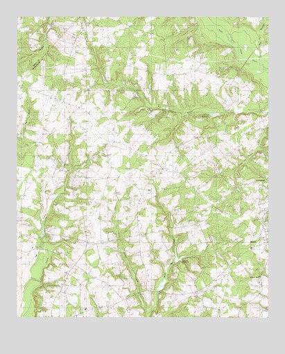
Harleys Millpond, SC USGS Topographic Map
Click on map above to begin viewing in our Map Viewer.

This topographic map contains these locations and features:
Feature Name Type Latitude Longitude GNIS ID View Map
Able-Corbitt PondReservoirN33.6202°W81.2348°1238065View Map
Able-Corbitt Pond Dam D-2048DamN33.6202°W81.2348°1238064View Map
Antioch ChurchChurchN33.5935°W81.2143°1242510View Map
Antioch SchoolSchoolN33.5957°W81.2140°1220221View Map
Bailey CemeteryCemeteryN33.5535°W81.2019°2681186View Map
Beaver Creek Baptist ChurchChurchN33.5454°W81.1379°1245009View Map
Bolen Mill CreekStreamN33.5013°W81.1837°1220879View Map
Bolins Mill Pond Dam D-3727DamN33.5118°W81.1782°1240328View Map
Davis Family CemeteryCemeteryN33.5588°W81.1930°2681198View Map
Flora Branch ChurchChurchN33.5802°W81.1782°1242631View Map
Flora Branch SchoolSchoolN33.5799°W81.1770°1222460View Map
Four Pines SchoolSchoolN33.5627°W81.1768°1222516View Map
Gleaton - Fogle - Corbett Family CemeteryCemeteryN33.5606°W81.1785°2681205View Map
Gleaton Family CemeteryCemeteryN33.5380°W81.1680°2681204View Map
Gospel Temple ChurchChurchN33.5279°W81.1812°1222781View Map
Harleys MillpondReservoirN33.5847°W81.1518°1238117View Map
Hopewell ChurchChurchN33.5824°W81.2234°1223288View Map
Hopewell Southern Methodist Church CemeteryCemeteryN33.5827°W81.2242°2681209View Map
Hughes Pond Dam D-2437DamN33.5868°W81.1765°1240306View Map
Jackson CemeteryCemeteryN33.5020°W81.1484°2681211View Map
Jeffcoat Pond (historical)ReservoirN33.5590°W81.1490°1223521View Map
Jones BridgeBridgeN33.6065°W81.1332°1223631View Map
Jones PondReservoirN33.5873°W81.1758°1223645View Map
Julia Academy (historical)SchoolN33.6193°W81.2176°1242674View Map
Magnolia School (historical)SchoolN33.5493°W81.2082°1242685View Map
Moods PondReservoirN33.5990°W81.2064°1238183View Map
Mount Beulah ChurchChurchN33.5618°W81.1773°1242706View Map
Mount Beulah Pentecostal Holiness ChurchChurchN33.5620°W81.1777°2490336View Map
Mount Beulah Pentecostal Holiness Church CemeteryCemeteryN33.5612°W81.1771°2681223View Map
Neeses CemeteryCemeteryN33.5200°W81.1280°2681227View Map
Neeses Fire TowerTowerN33.5393°W81.1570°1249781View Map
Neeses Primary SchoolSchoolN33.5290°W81.1332°1242723View Map
Penn BranchStreamN33.6065°W81.1284°1225358View Map
Pleasant Hill Baptist ChurchChurchN33.5307°W81.2382°1250166View Map
Pooles Pond Dam D-3699DamN33.5635°W81.2265°1240311View Map
Priester MillpondReservoirN33.5246°W81.1702°1238115View Map
Red Hill School (historical)SchoolN33.5832°W81.2495°1242796View Map
Rocky Swamp CemeteryCemeteryN33.5093°W81.1912°1242809View Map
Rocky Swamp ChurchChurchN33.5090°W81.1904°1250455View Map
Rocky Swamp Southern Methodist Church CemeteryCemeteryN33.5032°W81.1953°2681238View Map
Sand Hill SchoolSchoolN33.5210°W81.1440°1226331View Map
Sand Hill SchoolSchoolN33.5452°W81.2115°1226332View Map
SawyerdalePopulated PlaceN33.5913°W81.2309°1242840View Map
Sawyerdale Fire DepartmentBuildingN33.5913°W81.2329°2578854View Map
Sawyerdale SchoolSchoolN33.5915°W81.2334°1226432View Map
Seven Oaks Poultry FarmLocaleN33.5844°W81.2003°2635230View Map
South Carolina Noname 38012 D-3728 DamDamN33.5240°W81.1701°1238114View Map
South Carolina Noname 38013 D-3690 DamDamN33.5840°W81.1470°1238116View Map
South Carolina Noname 38066 D-3701 DamDamN33.5352°W81.2365°1238170View Map
South Carolina Noname 38072 D-3700 DamDamN33.5502°W81.2315°1238176View Map
South Carolina Noname 38083 D-3688 DamDamN33.5985°W81.2065°1238182View Map
South Goodland SchoolSchoolN33.5038°W81.2209°1250963View Map
Springfield DivisionCivilN33.5366°W81.2450°1938428View Map
Tampy Mill (historical)LocaleN33.5335°W81.2365°1242870View Map
W A Jones Pond Dam D-3702DamN33.5635°W81.2165°1240312View Map

Note: Coordinates in the location and feature list above are referenced to NAD83 datum.


Copyright (C) 2008-2025 Ryan Niemi / Sunset Dynamics ... All Rights Reserved