TopoQuest Logo
Do you find TopoQuest useful?
Help keep TopoQuest running and adding new maps/features by donating!
Bitcoin:  19c7KJd3qBynnjoSw5npx9KScwjBe4ifkT
Litecoin:  LXs6TkuXGGXo1vDsWCkWVdjQX94eUKd6ui
Home View Maps Find Maps Find Places Resources & Links


Swifton East, Arkansas Topographic Map

USGS Map Title: Swifton East, AR
USGS Map MRC: 35091G1
DRG (GeoTIFF) Download: o35091g1.tif


Neighboring USGS Topographic Map Quads:


  Strangers Home, AR  
35091H2
 

  Alicia, AR  
35091H1
 

  Podo Creek, AR  
35090H8
 

  Swifton West, AR  
35091G2
 

  Swifton East, AR  
35091G1
 

  Cash, AR  
35090G8
 

  Tuckerman, AR  
35091F2
 

  Grubbs, AR  
35091F1
 

  Risher, AR  
35090F8


Map MRC Location:

N36°
W92°
N36°
W91°
H8 H7 H6 H5 H4 H3 H2 H1
G8 G7 G6 G5 G4 G3 G2 G1
F8 F7 F6 F5 F4 F3 F2 F1
E8 E7 E6 E5 E4 E3 E2 E1
D8 D7 D6 D5 D4 D3 D2 D1
C8 C7 C6 C5 C4 C3 C2 C1
B8 B7 B6 B5 B4 B3 B2 B1
A8 A7 A6 A5 A4 A3 A2 A1
N35°
W92°
N35°
W91°

Swifton East, AR USGS 1:24K Topographic Map Preview:
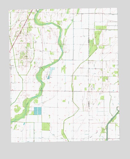
Swifton East, AR USGS Topographic Map
Click on map above to begin viewing in our Map Viewer.

This topographic map contains these locations and features:
Feature Name Type Latitude Longitude GNIS ID View Map
Arnold CemeteryCemeteryN35.8442°W91.0943°45931View Map
Arnold ChurchChurchN35.8356°W91.0873°45933View Map
Arnold School (historical)SchoolN35.8356°W91.0873°61807View Map
Bridge School (historical)SchoolN35.8204°W91.0898°61808View Map
Browns Mill (historical)LocaleN35.8179°W91.0004°64436View Map
Deep DitchCanalN35.8295°W91.0976°48442View Map
Denton IslandPopulated PlaceN35.7554°W91.0301°57645View Map
Earnest ChapelChurchN35.8212°W91.0007°48741View Map
Elm Grove School (historical)SchoolN35.8723°W91.0840°61813View Map
Fisher School (historical)SchoolN35.8176°W91.0101°64441View Map
Goetz School (historical)SchoolN35.7545°W91.1246°61814View Map
Gunner SloughStreamN35.8109°W91.0001°77095View Map
Hales Chapel (historical)ChurchN35.7959°W91.0232°64444View Map
Maple DitchCanalN35.8651°W91.1229°51656View Map
Murphys ChapelChurchN35.8204°W91.0893°77784View Map
Oak Grove School (historical)SchoolN35.7529°W91.0685°61828View Map
Page School (historical)SchoolN35.7940°W91.1243°61829View Map
Sneed ChurchChurchN35.8729°W91.1140°61833View Map
Sneed School (historical)SchoolN35.8729°W91.1137°81331View Map
Sunny Valley ChurchChurchN35.7701°W91.0351°55339View Map
Township of GlassCivilN35.8373°W91.1192°66725View Map
Willow CreekStreamN35.8726°W91.0910°56415View Map
Willow DitchCanalN35.7720°W91.0593°78781View Map
Worley CemeteryCemeteryN35.8078°W91.0121°56546View Map
Worthington SloughStreamN35.7781°W91.0487°64719View Map

Note: Coordinates in the location and feature list above are referenced to NAD83 datum.


Copyright (C) 2008-2024 Ryan Niemi / Sunset Dynamics ... All Rights Reserved