TopoQuest Logo
Do you find TopoQuest useful?
Help keep TopoQuest running and adding new maps/features by donating!
Bitcoin:  19c7KJd3qBynnjoSw5npx9KScwjBe4ifkT
Litecoin:  LXs6TkuXGGXo1vDsWCkWVdjQX94eUKd6ui
Home View Maps Find Maps Find Places Resources & Links


Sycamore, Kansas Topographic Map

USGS Map Title: Sycamore, KS
USGS Map MRC: 37095C6
DRG (GeoTIFF) Download: o37095c6.tif


Neighboring USGS Topographic Map Quads:


  Lafontaine, KS  
37095D7
 

  Neodesha, KS  
37095D6
 

  Morehead, KS  
37095D5
 

  Table Mound, KS  
37095C7
 

  Sycamore, KS  
37095C6
 

  Cherryvale, KS  
37095C5
 

  Bolton, KS  
37095B7
 

  Independence, KS  
37095B6
 

  Liberty, KS  
37095B5


Map MRC Location:

N38°
W96°
N38°
W95°
H8 H7 H6 H5 H4 H3 H2 H1
G8 G7 G6 G5 G4 G3 G2 G1
F8 F7 F6 F5 F4 F3 F2 F1
E8 E7 E6 E5 E4 E3 E2 E1
D8 D7 D6 D5 D4 D3 D2 D1
C8 C7 C6 C5 C4 C3 C2 C1
B8 B7 B6 B5 B4 B3 B2 B1
A8 A7 A6 A5 A4 A3 A2 A1
N37°
W96°
N37°
W95°

Sycamore, KS USGS 1:24K Topographic Map Preview:
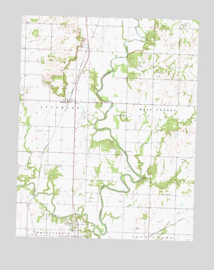
Sycamore, KS USGS Topographic Map
Click on map above to begin viewing in our Map Viewer.

This topographic map contains these locations and features:
Feature Name Type Latitude Longitude GNIS ID View Map
Baker School (historical)SchoolN37.2506°W95.7141°483838View Map
Bethel CemeteryCemeteryN37.2761°W95.6461°469833View Map
Brethren Church (historical)ChurchN37.2903°W95.7497°483841View Map
Cherryvale Junior High SchoolSchoolN37.2681°W95.7050°481100View Map
Choteau ChapelChurchN37.3198°W95.6749°469825View Map
Choteau CreekStreamN37.2859°W95.6639°469828View Map
Elk RiverStreamN37.2567°W95.6941°469392View Map
Fairview SchoolSchoolN37.3703°W95.6933°469817View Map
Gravel Hill SchoolSchoolN37.2817°W95.7016°469829View Map
Independence Country ClubLocaleN37.2537°W95.7132°485376View Map
Irish CreekStreamN37.2859°W95.6639°469827View Map
Irish Creek School (historical)SchoolN37.2759°W95.6569°483858View Map
KGGF - FM (Neodesha)BuildingN37.3727°W95.7272°2625235View Map
Kroner CemeteryCemeteryN37.3302°W95.7495°469823View Map
Larimer SchoolSchoolN37.2981°W95.7308°469826View Map
Little Bear MoundSummitN37.3531°W95.6980°469649View Map
Montgomery County Rural Fire District Station 6BuildingN37.3282°W95.7119°2111642View Map
Peebler School (historical)SchoolN37.2551°W95.7422°469831View Map
Prior CreekStreamN37.3451°W95.6844°469821View Map
Radical CemeteryCemeteryN37.2886°W95.7416°469830View Map
Radical School (historical)SchoolN37.2898°W95.7497°483872View Map
Rebel CreekStreamN37.2606°W95.6905°469832View Map
Saint Andrew's CemeteryCemeteryN37.2565°W95.6663°469834View Map
Salt CreekStreamN37.3737°W95.6680°469819View Map
SycamorePopulated PlaceN37.3270°W95.7155°469824View Map
Sycamore BridgeBridgeN37.3270°W95.6855°469822View Map
Sycamore CreekStreamN37.2792°W95.7450°469846View Map
Sycamore Valley Golf CourseLocaleN37.3016°W95.7072°2694611View Map
Township of West CherryCivilN37.3176°W95.6426°469820View Map
Turner BridgeBridgeN37.2992°W95.6750°469818View Map

Note: Coordinates in the location and feature list above are referenced to NAD83 datum.


Copyright (C) 2008-2025 Ryan Niemi / Sunset Dynamics ... All Rights Reserved