TopoQuest Logo
Do you find TopoQuest useful?
Help keep TopoQuest running and adding new maps/features by donating!
Bitcoin:  19c7KJd3qBynnjoSw5npx9KScwjBe4ifkT
Litecoin:  LXs6TkuXGGXo1vDsWCkWVdjQX94eUKd6ui
Home View Maps Find Maps Find Places Resources & Links


Table Mound, Kansas Topographic Map

USGS Map Title: Table Mound, KS
USGS Map MRC: 37095C7
DRG (GeoTIFF) Download: o37095c7.tif


Neighboring USGS Topographic Map Quads:


  Buxton, KS  
37095D8
 

  Lafontaine, KS  
37095D7
 

  Neodesha, KS  
37095D6
 

  Elk City, KS  
37095C8
 

  Table Mound, KS  
37095C7
 

  Sycamore, KS  
37095C6
 

  Caney NW, KS  
37095B8
 

  Bolton, KS  
37095B7
 

  Independence, KS  
37095B6


Map MRC Location:

N38°
W96°
N38°
W95°
H8 H7 H6 H5 H4 H3 H2 H1
G8 G7 G6 G5 G4 G3 G2 G1
F8 F7 F6 F5 F4 F3 F2 F1
E8 E7 E6 E5 E4 E3 E2 E1
D8 D7 D6 D5 D4 D3 D2 D1
C8 C7 C6 C5 C4 C3 C2 C1
B8 B7 B6 B5 B4 B3 B2 B1
A8 A7 A6 A5 A4 A3 A2 A1
N37°
W96°
N37°
W95°

Table Mound, KS USGS 1:24K Topographic Map Preview:
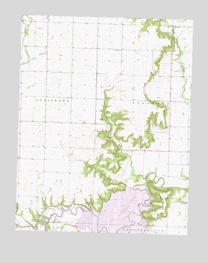
Table Mound, KS USGS Topographic Map
Click on map above to begin viewing in our Map Viewer.

This topographic map contains these locations and features:
Feature Name Type Latitude Longitude GNIS ID View Map
Card CreekStreamN37.2570°W95.8508°469391View Map
Card Creek Public Use AreaParkN37.2570°W95.8480°481097View Map
Central School (historical)SchoolN37.3628°W95.8375°483844View Map
CranePopulated PlaceN37.2795°W95.7969°484488View Map
Elk City DamDamN37.2767°W95.7905°481095View Map
Elk City LakeReservoirN37.2574°W95.8023°479838View Map
Elk City State ParkParkN37.2556°W95.7711°479841View Map
Elk City State Park Comfort Cove Camping AreaLocaleN37.2554°W95.7763°2624946View Map
Elk City State Park OfficeBuildingN37.2578°W95.7748°2625194View Map
Elk City State Park Prairie Meadow Camping AreaLocaleN37.2559°W95.7713°2624947View Map
Elk City State Park Sunset Point Camping AreaLocaleN37.2557°W95.7790°2624948View Map
Elk City State Park Timber Road Camping AreaLocaleN37.2582°W95.7787°2624949View Map
Elk City Wildlife AreaParkN37.2667°W95.7919°479815View Map
Elm BranchStreamN37.3659°W95.8705°469847View Map
Farm Ridge CemeteryCemeteryN37.3561°W95.8023°469839View Map
Farm Ridge School (historical)SchoolN37.3562°W95.8155°483852View Map
Gamble SchoolSchoolN37.2987°W95.7886°469840View Map
Gordon CreekStreamN37.2840°W95.7911°469842View Map
Le HuntPopulated PlaceN37.2692°W95.7519°484489View Map
Mulberry CreekStreamN37.3487°W95.8689°469848View Map
Oak Ridge Public Use AreaParkN37.2501°W95.8558°481098View Map
Parker CemeteryCemeteryN37.2631°W95.8573°469843View Map
Prairie School (historical)SchoolN37.3201°W95.8378°483869View Map
Racket CreekStreamN37.2823°W95.7811°469841View Map
Rich Valley School (historical)SchoolN37.2695°W95.7922°483873View Map
Simpson CemeteryCemeteryN37.3273°W95.8187°469835View Map
Simpson Church (historical)ChurchN37.3273°W95.8183°483877View Map
Squaw CreekStreamN37.2565°W95.7883°469390View Map
Squaw Creek Cove North Public Use AreaParkN37.2653°W95.7780°481096View Map
Sternerton (historical)LocaleN37.3559°W95.8028°482382View Map
Sycamore Valley ChurchChurchN37.3712°W95.7650°469837View Map
Table MoundSummitN37.2709°W95.7675°469844View Map
Township of SycamoreCivilN37.3213°W95.7506°469845View Map
White CemeteryCemeteryN37.3674°W95.8640°469838View Map

Note: Coordinates in the location and feature list above are referenced to NAD83 datum.


Copyright (C) 2008-2025 Ryan Niemi / Sunset Dynamics ... All Rights Reserved