TopoQuest Logo
Do you find TopoQuest useful?
Help keep TopoQuest running and adding new maps/features by donating!
Bitcoin:  19c7KJd3qBynnjoSw5npx9KScwjBe4ifkT
Litecoin:  LXs6TkuXGGXo1vDsWCkWVdjQX94eUKd6ui
Home View Maps Find Maps Find Places Resources & Links


T A Ranch, Wyoming Topographic Map

USGS Map Title: T A Ranch, WY
USGS Map MRC: 44106B6
DRG (GeoTIFF) Download: o44106b6.tif


Neighboring USGS Topographic Map Quads:


  North Ridge, WY  
44106C7
 

  Buffalo, WY  
44106C6
 

  Buffalo SE, WY  
44106C5
 

  Klondike Ranch, WY  
44106B7
 

  T A Ranch, WY  
44106B6
 

  T A Ranch NE, WY  
44106B5
 

  Robinson Canyon, WY  
44106A7
 

  Purdy Reservoir, WY  
44106A6
 

  Trabing, WY  
44106A5


Map MRC Location:

N45°
W107°
N45°
W106°
H8 H7 H6 H5 H4 H3 H2 H1
G8 G7 G6 G5 G4 G3 G2 G1
F8 F7 F6 F5 F4 F3 F2 F1
E8 E7 E6 E5 E4 E3 E2 E1
D8 D7 D6 D5 D4 D3 D2 D1
C8 C7 C6 C5 C4 C3 C2 C1
B8 B7 B6 B5 B4 B3 B2 B1
A8 A7 A6 A5 A4 A3 A2 A1
N44°
W107°
N44°
W106°

T A Ranch, WY USGS 1:24K Topographic Map Preview:
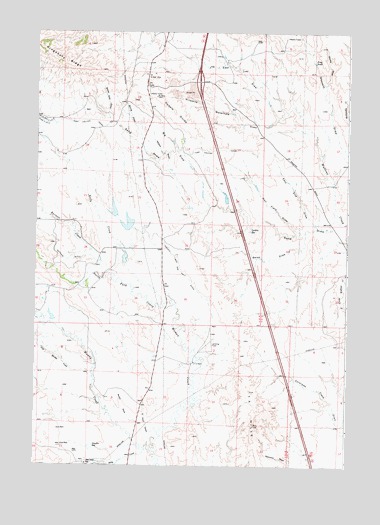
T A Ranch, WY USGS Topographic Map
Click on map above to begin viewing in our Map Viewer.

This topographic map contains these locations and features:
Feature Name Type Latitude Longitude GNIS ID View Map
Basch DamDamN44.1683°W106.7456°1607016View Map
Basch ReservoirReservoirN44.1678°W106.7434°1607017View Map
Bates DrawValleyN44.1908°W106.6423°1585196View Map
Big DrawValleyN44.2005°W106.6814°1585449View Map
Billy CreekStreamN44.1294°W106.7050°1598187View Map
Billy Creek SchoolSchoolN44.1255°W106.7289°1585545View Map
Burnett CreekStreamN44.1791°W106.7231°1598511View Map
Coyote DrawValleyN44.2353°W106.6339°1587145View Map
Dowlin ReservoirReservoirN44.1305°W106.7256°1587758View Map
Dry Muddy CreekStreamN44.1503°W106.7262°1599376View Map
East End DrawValleyN44.1969°W106.6403°1588042View Map
East Four DrawValleyN44.1344°W106.7037°1588105View Map
Eder DrawValleyN44.2258°W106.6542°1588173View Map
Fort Collins CanalCanalN44.2247°W106.7289°1588636View Map
Frog PondLakeN44.2414°W106.6394°1588762View Map
Gerkin ReservoirReservoirN44.1928°W106.6642°1588867View Map
Hall Field DrawValleyN44.1930°W106.6445°1589252View Map
Highway DamDamN44.2016°W106.6956°1607532View Map
Highway ReservoirReservoirN44.2016°W106.6956°1607533View Map
Kelly CreekStreamN44.1722°W106.6989°1600688View Map
Kelly DamDamN44.1833°W106.7123°1607034View Map
Kelly ReservoirReservoirN44.1848°W106.7143°1607035View Map
Kingsbury RidgeRidgeN44.2419°W106.7381°1600726View Map
Kingsbury Todd Number 1 DamDamN44.2016°W106.7189°1607044View Map
Kingsbury Todd Number 1 ReservoirReservoirN44.1986°W106.7190°1607045View Map
Kingsbury Todd Number 2 DamDamN44.2016°W106.7173°1607046View Map
Kingsbury Todd Number 2 ReservoirReservoirN44.2016°W106.7173°1607047View Map
Muddy CreekStreamN44.1300°W106.7031°1601619View Map
Neilson DrawValleyN44.2130°W106.6978°1591999View Map
Ninemile Waterhole DrawValleyN44.2236°W106.6623°1592064View Map
Ridge Place Number 2 DamDamN44.2233°W106.7189°1607994View Map
Ridge Place Number 2 ReservoirReservoirN44.2233°W106.7189°1607995View Map
Sand DrawValleyN44.1961°W106.6303°1593863View Map
South Side DrawValleyN44.2258°W106.7214°1594734View Map
Spring DrawValleyN44.2233°W106.7103°1594893View Map
T A HillsRangeN44.1366°W106.6617°1596952View Map
T A RanchLocaleN44.1547°W106.6859°1595264View Map
Tisdale DivideRidgeN44.2269°W106.6953°1595601View Map
Twenty and One Half DitchCanalN44.1833°W106.6925°1595756View Map
Watkins DitchCanalN44.1875°W106.7425°1604525View Map

Note: Coordinates in the location and feature list above are referenced to NAD83 datum.


Copyright (C) 2008-2025 Ryan Niemi / Sunset Dynamics ... All Rights Reserved