TopoQuest Logo
Do you find TopoQuest useful?
Help keep TopoQuest running and adding new maps/features by donating!
Bitcoin:  19c7KJd3qBynnjoSw5npx9KScwjBe4ifkT
Litecoin:  LXs6TkuXGGXo1vDsWCkWVdjQX94eUKd6ui
Home View Maps Find Maps Find Places Resources & Links


Tabby Mountain, Utah Topographic Map

USGS Map Title: Tabby Mountain, UT
USGS Map MRC: 40110C7
DRG (GeoTIFF) Download: o40110c7.tif


Neighboring USGS Topographic Map Quads:


  Wolf Creek, UT  
40110D8
 

  Hanna, UT  
40110D7
 

  Farm Creek Peak, UT  
40110D6
 

  Raspberry Knoll, UT  
40110C8
 

  Tabby Mountain, UT  
40110C7
 

  Tabiona, UT  
40110C6
 

  Deep Creek Canyon, UT  
40110B8
 

  Fruitland, UT  
40110B7
 

  Strawberry Pinnacles, UT  
40110B6


Map MRC Location:

N41°
W111°
N41°
W110°
H8 H7 H6 H5 H4 H3 H2 H1
G8 G7 G6 G5 G4 G3 G2 G1
F8 F7 F6 F5 F4 F3 F2 F1
E8 E7 E6 E5 E4 E3 E2 E1
D8 D7 D6 D5 D4 D3 D2 D1
C8 C7 C6 C5 C4 C3 C2 C1
B8 B7 B6 B5 B4 B3 B2 B1
A8 A7 A6 A5 A4 A3 A2 A1
N40°
W111°
N40°
W110°

Tabby Mountain, UT USGS 1:24K Topographic Map Preview:
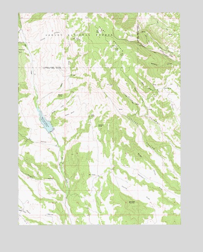
Tabby Mountain, UT USGS Topographic Map
Click on map above to begin viewing in our Map Viewer.

This topographic map contains these locations and features:
Feature Name Type Latitude Longitude GNIS ID View Map
Beer SpringSpringN40.2794°W110.8166°1425401View Map
Big LakeLakeN40.3638°W110.8127°1425524View Map
Birch SpringSpringN40.3138°W110.8199°1425618View Map
Birch SpringSpringN40.3308°W110.7637°1425619View Map
Chuck HollowValleyN40.3547°W110.8677°1426628View Map
Coyote DrawValleyN40.2552°W110.7679°1427040View Map
Grey Wolf MountainSummitN40.2633°W110.7910°1428412View Map
Kersha BenchBenchN40.3155°W110.8360°1429332View Map
Kersha CreekStreamN40.3111°W110.8513°1442304View Map
Little Bear HollowValleyN40.3638°W110.8741°1442663View Map
Little LakeLakeN40.3524°W110.7988°1429752View Map
Mill HollowValleyN40.2980°W110.8491°1443459View Map
Red Creek DamDamN40.3033°W110.8491°1434795View Map
Red Creek ReservoirReservoirN40.3089°W110.8537°1431635View Map
Red Creek ReservoirReservoirN40.3033°W110.8491°1434794View Map
Right Fork Grass HollowValleyN40.2577°W110.8691°1444921View Map
Right Fork Mill HollowValleyN40.3147°W110.7763°1431804View Map
Rock SpringSpringN40.3595°W110.8311°1431933View Map
Rough HollowValleyN40.2655°W110.8393°1445158View Map
Rough HollowValleyN40.2708°W110.7632°1432017View Map
Santaquin SpringSpringN40.3086°W110.8149°1432239View Map
Seth HollowValleyN40.3269°W110.7671°1432330View Map
Tabby CreekStreamN40.3213°W110.8616°1433148View Map
Tabby MountainSummitN40.3502°W110.7968°1433149View Map
Thunder Ridge AirparkAirportN40.2689°W110.8703°2443221View Map
Timber CanyonValleyN40.3455°W110.7540°1433525View Map
Whiskey SpringSpringN40.3256°W110.8414°1434152View Map

Note: Coordinates in the location and feature list above are referenced to NAD83 datum.


Copyright (C) 2008-2024 Ryan Niemi / Sunset Dynamics ... All Rights Reserved