TopoQuest Logo
Do you find TopoQuest useful?
Help keep TopoQuest running and adding new maps/features by donating!
Bitcoin:  19c7KJd3qBynnjoSw5npx9KScwjBe4ifkT
Litecoin:  LXs6TkuXGGXo1vDsWCkWVdjQX94eUKd6ui
Home View Maps Find Maps Find Places Resources & Links


Bloomfield, Vermont Topographic Map

USGS Map Title: Bloomfield, VT
USGS Map MRC: 44071G6
DRG (GeoTIFF) Download: o44071g6.tif


Neighboring USGS Topographic Map Quads:


  Norton Pond, VT  
44071H7
 

  Averill, VT  
44071H6
 

  Monadnock Mountain, VT  
44071H5
 

  Spectacle Pond, VT  
44071G7
 

  Bloomfield, VT  
44071G6
 

  Tinkerville, NH  
44071G5
 

  Seneca Mountain, VT  
44071F7
 

  Maidstone Lake, VT  
44071F6
 

  Stratford, NH  
44071F5


Map MRC Location:

N45°
W72°
N45°
W71°
H8 H7 H6 H5 H4 H3 H2 H1
G8 G7 G6 G5 G4 G3 G2 G1
F8 F7 F6 F5 F4 F3 F2 F1
E8 E7 E6 E5 E4 E3 E2 E1
D8 D7 D6 D5 D4 D3 D2 D1
C8 C7 C6 C5 C4 C3 C2 C1
B8 B7 B6 B5 B4 B3 B2 B1
A8 A7 A6 A5 A4 A3 A2 A1
N44°
W72°
N44°
W71°

Bloomfield, VT USGS 1:24K Topographic Map Preview:
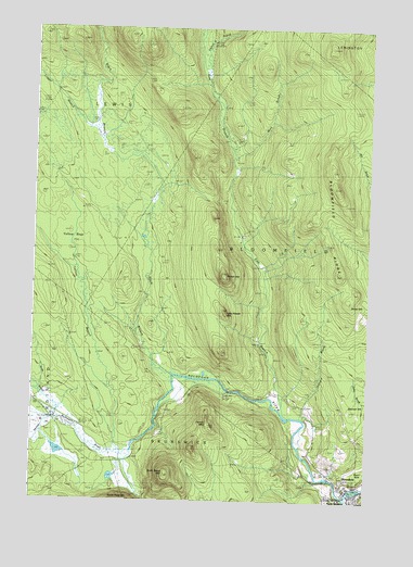
Bloomfield, VT USGS Topographic Map
Click on map above to begin viewing in our Map Viewer.

This topographic map contains these locations and features:
Feature Name Type Latitude Longitude GNIS ID View Map
Big DamDamN44.8267°W71.7065°1456412View Map
Black Branch Nulhegan RiverStreamN44.7837°W71.6984°1456438View Map
BloomfieldPopulated PlaceN44.7539°W71.6323°1456483View Map
Bloomfield RidgeRidgeN44.8173°W71.6393°1456485View Map
Brooks DamDamN44.8409°W71.7218°1456586View Map
Buzzell DamDamN44.8617°W71.7234°1456706View Map
Camp Number FifteenLocaleN44.7981°W71.7012°1456741View Map
Camp Number FiveLocaleN44.8517°W71.6462°1456750View Map
Camp Number FourLocaleN44.8412°W71.6754°1456749View Map
Camp Number SeventeenLocaleN44.8239°W71.6976°1456743View Map
Camp Number SixLocaleN44.8614°W71.6862°1456751View Map
Camp Number TenLocaleN44.8720°W71.6851°1456736View Map
Camp Number ThreeLocaleN44.8206°W71.6720°1456748View Map
Dam Number OneDamN44.8109°W71.6640°1457093View Map
Dam Number ThreeDamN44.8559°W71.6815°1457095View Map
Dam Number TwoDamN44.8373°W71.6745°1457094View Map
East Branch Nulhegan RiverStreamN44.7725°W71.6534°1457258View Map
First BrookStreamN44.7562°W71.6429°1457432View Map
Fisher BrookStreamN44.8634°W71.6865°1457438View Map
French MountainSummitN44.7712°W71.6837°1457494View Map
Hibbard BrookStreamN44.7725°W71.6501°1457809View Map
Little Potash MountainSummitN44.8003°W71.6776°1458251View Map
Logger BranchStreamN44.8484°W71.7281°1458262View Map
Mink BrookStreamN44.8428°W71.6759°1458495View Map
North Branch Nulhegan RiverStreamN44.7720°W71.7418°1458701View Map
North Notch MountainSummitN44.7570°W71.6998°1458749View Map
North StratfordPopulated PlaceN44.7517°W71.6287°868815View Map
North Stratford Post OfficePost OfficeN44.7519°W71.6295°1916322View Map
Nulhegan RiverStreamN44.7550°W71.6251°1458793View Map
Peanut DamDamN44.8414°W71.7076°1458922View Map
Potash MountainSummitN44.8103°W71.6790°1459059View Map
Second BrookStreamN44.7592°W71.6540°1459443View Map
Silvio O Conte National Fish And Wildlife RefugeParkN44.8441°W71.7452°2765506View Map
Spencer HillSummitN44.7748°W71.6315°1459637View Map
Stone DamDamN44.7792°W71.6776°1459728View Map
Stratford Police DepartmentBuildingN44.7514°W71.6284°2753028View Map
Town of BloomfieldCivilN44.8121°W71.6446°1462044View Map
Town of LewisCivilN44.8669°W71.7490°1462134View Map
Yellow BogsSwampN44.8203°W71.7315°1460338View Map
Yellow Branch Nulhegan RiverStreamN44.7639°W71.7176°1460339View Map

Note: Coordinates in the location and feature list above are referenced to NAD83 datum.


Copyright (C) 2008-2024 Ryan Niemi / Sunset Dynamics ... All Rights Reserved