TopoQuest Logo
Do you find TopoQuest useful?
Help keep TopoQuest running and adding new maps/features by donating!
Bitcoin:  19c7KJd3qBynnjoSw5npx9KScwjBe4ifkT
Litecoin:  LXs6TkuXGGXo1vDsWCkWVdjQX94eUKd6ui
Home View Maps Find Maps Find Places Resources & Links


Maidstone Lake, Vermont Topographic Map

USGS Map Title: Maidstone Lake, VT
USGS Map MRC: 44071F6
DRG (GeoTIFF) Download: o44071f6.tif


Neighboring USGS Topographic Map Quads:


  Spectacle Pond, VT  
44071G7
 

  Bloomfield, VT  
44071G6
 

  Tinkerville, NH  
44071G5
 

  Seneca Mountain, VT  
44071F7
 

  Maidstone Lake, VT  
44071F6
 

  Stratford, NH  
44071F5
 

  Gallup Mills, VT  
44071E7
 

  Stone Mountain, VT  
44071E6
 

  Groveton, NH  
44071E5


Map MRC Location:

N45°
W72°
N45°
W71°
H8 H7 H6 H5 H4 H3 H2 H1
G8 G7 G6 G5 G4 G3 G2 G1
F8 F7 F6 F5 F4 F3 F2 F1
E8 E7 E6 E5 E4 E3 E2 E1
D8 D7 D6 D5 D4 D3 D2 D1
C8 C7 C6 C5 C4 C3 C2 C1
B8 B7 B6 B5 B4 B3 B2 B1
A8 A7 A6 A5 A4 A3 A2 A1
N44°
W72°
N44°
W71°

Maidstone Lake, VT USGS 1:24K Topographic Map Preview:
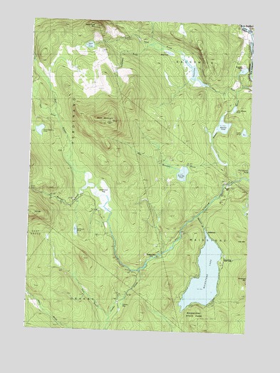
Maidstone Lake, VT USGS Topographic Map
Click on map above to begin viewing in our Map Viewer.

This topographic map contains these locations and features:
Feature Name Type Latitude Longitude GNIS ID View Map
Browns MillPopulated PlaceN44.6856°W71.6345°1460399View Map
Brunswick SpringsPopulated PlaceN44.7364°W71.6323°1456615View Map
Bull MountainSummitN44.6728°W71.7462°1456637View Map
BullthroatPopulated PlaceN44.6639°W71.6484°1456644View Map
Camping Area ALocaleN44.6367°W71.6451°1919305View Map
Camping Area BLocaleN44.6356°W71.6556°1919306View Map
Connecticut CemeteryCemeteryN44.7439°W71.6307°1919322View Map
Dennis PondLakeN44.7295°W71.6579°1457145View Map
Dennis Pond BrookStreamN44.7234°W71.6323°1457146View Map
Essex CountyCivilN44.7279°W71.7362°1461761View Map
Ferdinand BogSwampN44.6835°W71.7140°1457422View Map
Fitch BrookStreamN44.6317°W71.7023°1457442View Map
Granby BogSwampN44.6353°W71.6958°1457596View Map
Granby StreamStreamN44.6503°W71.6854°1457599View Map
Little Wheeler PondLakeN44.7155°W71.6346°1458256View Map
Loon TrailTrailN44.6345°W71.6634°1919360View Map
Madison BrookStreamN44.6842°W71.7156°1458333View Map
Maidstone BrookStreamN44.6723°W71.6534°1458335View Map
Maidstone LakeLakeN44.6477°W71.6489°1458337View Map
Maidstone State ParkForestN44.6312°W71.6531°1458338View Map
Maidstone State Park Nature CenterBuildingN44.6528°W71.6390°1919365View Map
Moose TrailTrailN44.6345°W71.6479°1919369View Map
Mud PondLakeN44.7374°W71.6721°1458623View Map
North Branch Paul StreamStreamN44.7126°W71.7365°1458703View Map
Notch PondLakeN44.7399°W71.7176°1458788View Map
Notch Pond BrookStreamN44.7342°W71.6579°1458789View Map
Notch Pond MountainSummitN44.7481°W71.7134°1458790View Map
Shore TrailTrailN44.6370°W71.6523°1919402View Map
South American PondLakeN44.7052°W71.7445°1459566View Map
Stratford Elementary SchoolSchoolN44.7494°W71.6257°2500296View Map
Stratford High SchoolSchoolN44.7494°W71.6257°2500297View Map
Telephone BrookStreamN44.7409°W71.6823°1459835View Map
Town of BrunswickCivilN44.7318°W71.6624°1462057View Map
Tuttle PondLakeN44.7061°W71.6290°1459973View Map
Unknown PondLakeN44.6650°W71.7226°1459997View Map
Walker DamDamN44.6564°W71.6745°1460044View Map
West MountainSummitN44.7098°W71.7040°1460159View Map
West Mountain BrookStreamN44.6953°W71.6412°1460160View Map
West Mountain PondLakeN44.6889°W71.6631°1460161View Map
Wheeler PondLakeN44.7088°W71.6407°1460200View Map

Note: Coordinates in the location and feature list above are referenced to NAD83 datum.


Copyright (C) 2008-2025 Ryan Niemi / Sunset Dynamics ... All Rights Reserved