TopoQuest Logo
Do you find TopoQuest useful?
Help keep TopoQuest running and adding new maps/features by donating!
Bitcoin:  19c7KJd3qBynnjoSw5npx9KScwjBe4ifkT
Litecoin:  LXs6TkuXGGXo1vDsWCkWVdjQX94eUKd6ui
Home View Maps Find Maps Find Places Resources & Links


Milky Way, Tennessee Topographic Map

USGS Map Title: Milky Way, TN
USGS Map MRC: 35087C1
DRG (GeoTIFF) Download: o35087c1.tif


Neighboring USGS Topographic Map Quads:


  Sandy Hook, TN  
35087D2
 

  Lynnville, TN  
35087D1
 

  Campbells Station, TN  
35086D8
 

  Campbellsville, TN  
35087C2
 

  Milky Way, TN  
35087C1
 

  Brick Church, TN  
35086C8
 

  Bodenham, TN  
35087B2
 

  Pulaski, TN  
35087B1
 

  Tarpley, TN  
35086B8


Map MRC Location:

N36°
W88°
N36°
W87°
H8 H7 H6 H5 H4 H3 H2 H1
G8 G7 G6 G5 G4 G3 G2 G1
F8 F7 F6 F5 F4 F3 F2 F1
E8 E7 E6 E5 E4 E3 E2 E1
D8 D7 D6 D5 D4 D3 D2 D1
C8 C7 C6 C5 C4 C3 C2 C1
B8 B7 B6 B5 B4 B3 B2 B1
A8 A7 A6 A5 A4 A3 A2 A1
N35°
W88°
N35°
W87°

Milky Way, TN USGS 1:24K Topographic Map Preview:
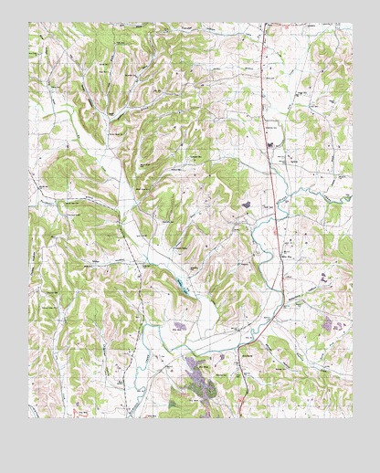
Milky Way, TN USGS Topographic Map
Click on map above to begin viewing in our Map Viewer.

This topographic map contains these locations and features:
Feature Name Type Latitude Longitude GNIS ID View Map
Abernathy CemeteryCemeteryN35.2970°W87.0628°1275423View Map
Abernathy CemeteryCemeteryN35.3117°W87.0731°1275424View Map
African HollowValleyN35.2756°W87.0340°1275502View Map
Allen CemeteryCemeteryN35.3531°W87.0728°1275581View Map
Apple HillSummitN35.3520°W87.0592°1647317View Map
Ball BranchStreamN35.3473°W87.0872°1304939View Map
Ball HollowValleyN35.3485°W87.0869°1647319View Map
Ballentine HollowValleyN35.2861°W87.0269°1276247View Map
Big CreekStreamN35.2734°W87.0645°1277277View Map
Briar Ridge CemeteryCemeteryN35.3653°W87.1206°1643981View Map
Briar Ridge ChurchChurchN35.3645°W87.1208°1278317View Map
Briar Ridge School (historical)SchoolN35.3648°W87.1208°1316258View Map
Briggs CemeteryCemeteryN35.3523°W87.0172°1278378View Map
Buford CemeteryCemeteryN35.2862°W87.0194°1278926View Map
BufordsPopulated PlaceN35.3320°W87.0256°1305513View Map
Carpenter CemeteryCemeteryN35.3323°W87.0625°1279703View Map
Carpenter CemeteryCemeteryN35.3578°W87.0825°1279704View Map
Carvell CemeteryCemeteryN35.3456°W87.0914°1279831View Map
Chapman CemeteryCemeteryN35.2892°W87.1181°1280259View Map
Chapman HollowValleyN35.2588°W87.0875°1305859View Map
Cook CemeteryCemeteryN35.3592°W87.0939°1281109View Map
Daught CemeteryCemeteryN35.3498°W87.0067°1306266View Map
Dickerson CemeteryCemeteryN35.3417°W87.0339°1306340View Map
East Fork Lynn CreekStreamN35.3681°W87.0339°1283354View Map
Eldridge HollowValleyN35.3724°W87.0439°1283617View Map
Evans CemeteryCemeteryN35.3576°W87.0339°1644010View Map
Everbright CemeteryCemeteryN35.3211°W87.0058°2663878View Map
Fry BranchStreamN35.3690°W87.0358°1284990View Map
Giles County Fire and Rescue Squad RichlandBuildingN35.3281°W87.0352°2653633View Map
Gileston (historical)Populated PlaceN35.3667°W87.0167°1310375View Map
Hart CemeteryCemeteryN35.3484°W87.0164°1287037View Map
Haywood ChurchChurchN35.3142°W87.0053°1287255View Map
Haywood CreekStreamN35.2806°W87.0325°1287256View Map
Haywood School (historical)SchoolN35.3145°W87.0050°1316276View Map
Holt Lake (historical)LakeN35.2617°W87.0875°1310376View Map
Holt SpringSpringN35.2615°W87.0882°1288171View Map
Hopewell CemeteryCemeteryN35.3212°W87.0058°2663838View Map
Hopewell CemeteryCemeteryN35.3232°W87.0012°2745925View Map
Joines CemeteryCemeteryN35.3617°W87.0975°1289678View Map
Lake GalileeReservoirN35.3201°W87.0400°1301742View Map
Lake Galilee DamDamN35.3201°W87.0400°1301743View Map
Locke BranchStreamN35.3462°W87.1145°1291759View Map
Lynn CreekStreamN35.3579°W87.0239°1292351View Map
Lynnville Division (historical)CensusN35.3729°W87.0778°1648708View Map
Mars MausoleumCemeteryN35.3203°W87.0467°1316284View Map
Martin HollowValleyN35.3046°W87.0733°1647328View Map
Milky WayLocaleN35.3015°W87.0275°1293785View Map
Milky Way FarmLocaleN35.3079°W87.0464°1316285View Map
Miller CemeteryCemeteryN35.2981°W87.0994°1293914View Map
Miller HollowValleyN35.3004°W87.0801°1293949View Map
Minnow BranchStreamN35.3306°W87.0975°1294058View Map
Minnow Branch ChurchChurchN35.3392°W87.0939°1294061View Map
Morris Mill (historical)LocaleN35.3381°W87.1061°1316287View Map
Morris Town CemeteryCemeteryN35.3176°W87.1108°1294439View Map
Mount Olivet CemeteryCemeteryN35.3295°W87.0819°1294719View Map
Mount Olivet ChurchChurchN35.3220°W87.0783°1294724View Map
Mount Ollie School (historical)SchoolN35.3226°W87.0783°1316288View Map
New Hope ChurchChurchN35.3140°W87.1100°1295523View Map
North Fork Haywood CreekStreamN35.2679°W87.0167°1295889View Map
OlivetPopulated PlaceN35.2942°W87.0272°1315652View Map
Olivet School (historical)SchoolN35.2942°W87.0258°1316293View Map
Parsons BranchStreamN35.3215°W87.0125°1296895View Map
Parsons Mill (historical)LocaleN35.2987°W87.0750°1316294View Map
Petty CemeteryCemeteryN35.3681°W87.0908°1297274View Map
Pleasant ValleyLocaleN35.3037°W87.0692°1297930View Map
Pleasant Valley School (historical)SchoolN35.3042°W87.0692°1316297View Map
Reynold CemeteryCemeteryN35.2656°W87.0253°1299243View Map
Rhea BranchStreamN35.3176°W87.0845°1310387View Map
RiversburgPopulated PlaceN35.2698°W87.0439°1299513View Map
Riversburg StationLocaleN35.2779°W87.0442°1316307View Map
Robertson Fork CreekStreamN35.3201°W87.0247°1303541View Map
Sanders LakeLakeN35.2928°W87.0665°1300706View Map
Shadden CemeteryCemeteryN35.2640°W87.0528°1301145View Map
Smith HollowValleyN35.3433°W87.0944°1270681View Map
Tacker BranchStreamN35.3623°W87.0270°1272032View Map
Tinen CemeteryCemeteryN35.2640°W87.0453°1304112View Map
Tinnon Burial GroundCemeteryN35.2711°W87.0293°2664117View Map
Waco School (historical)SchoolN35.3731°W87.0356°1322670View Map
Welcome Valley Baptist ChurchChurchN35.2848°W87.1136°1304439View Map
Whitaker BranchStreamN35.2979°W87.0714°1274320View Map
Wilkerson CemeteryCemeteryN35.2987°W87.0814°1274586View Map
Wilsford CemeteryCemeteryN35.3281°W87.0703°1274784View Map
Yokley CemeteryCemeteryN35.3540°W87.1161°1275299View Map
Zucarello BranchStreamN35.3117°W87.0889°1304739View Map

Note: Coordinates in the location and feature list above are referenced to NAD83 datum.


Copyright (C) 2008-2024 Ryan Niemi / Sunset Dynamics ... All Rights Reserved