TopoQuest Logo
Do you find TopoQuest useful?
Help keep TopoQuest running and adding new maps/features by donating!
Bitcoin:  19c7KJd3qBynnjoSw5npx9KScwjBe4ifkT
Litecoin:  LXs6TkuXGGXo1vDsWCkWVdjQX94eUKd6ui
Home View Maps Find Maps Find Places Resources & Links


Creel, Alabama Topographic Map

USGS Map Title: Creel, AL
USGS Map MRC: 33086G8
DRG (GeoTIFF) Download: o33086g8.tif


Neighboring USGS Topographic Map Quads:


  Cold Springs, AL  
33087H1
 

  Arkadelphia, AL  
33086H8
 

  Blount Springs, AL  
33086H7
 

  Sipsey, AL  
33087G1
 

  Creel, AL  
33086G8
 

  Warrior, AL  
33086G7
 

  Dora, AL  
33087F1
 

  Brookside, AL  
33086F8
 

  Gardendale, AL  
33086F7


Map MRC Location:

N34°
W87°
N34°
W86°
H8 H7 H6 H5 H4 H3 H2 H1
G8 G7 G6 G5 G4 G3 G2 G1
F8 F7 F6 F5 F4 F3 F2 F1
E8 E7 E6 E5 E4 E3 E2 E1
D8 D7 D6 D5 D4 D3 D2 D1
C8 C7 C6 C5 C4 C3 C2 C1
B8 B7 B6 B5 B4 B3 B2 B1
A8 A7 A6 A5 A4 A3 A2 A1
N33°
W87°
N33°
W86°

Creel, AL USGS 1:24K Topographic Map Preview:
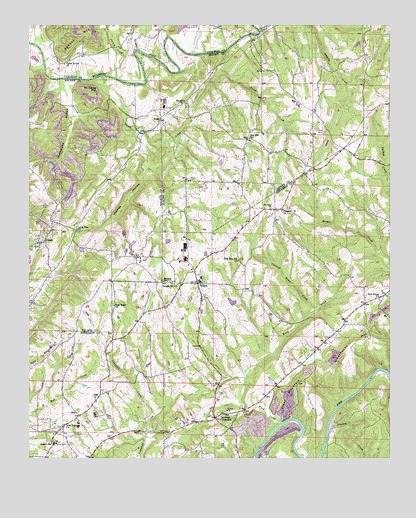
Creel, AL USGS Topographic Map
Click on map above to begin viewing in our Map Viewer.

This topographic map contains these locations and features:
Feature Name Type Latitude Longitude GNIS ID View Map
Antioch ChurchChurchN33.8012°W86.9525°113161View Map
Bagley Junior High SchoolSchoolN33.7545°W86.9914°165351View Map
Bagley MeadowsPopulated PlaceN33.7540°W86.9939°1700534View Map
Beltona MineMineN33.7779°W86.8944°146117View Map
Bohannon MineMineN33.8668°W86.9889°134864View Map
Carpet Rock MineMineN33.8390°W86.9972°135926View Map
Chicken House CreekStreamN33.7923°W86.9019°116036View Map
CornerPopulated PlaceN33.8004°W86.9422°116654View Map
Corner Elementary SchoolSchoolN33.8004°W86.9408°144114View Map
Corner High SchoolSchoolN33.8012°W86.9408°144115View Map
Corner Volunteer Fire and Rescue Service Station 1BuildingN33.8077°W86.9399°2682936View Map
Corner Volunteer Fire and Rescue Service Station 2BuildingN33.7801°W86.9014°2682695View Map
CreelPopulated PlaceN33.8132°W86.9944°116840View Map
Crooked CreekStreamN33.7584°W86.8961°116884View Map
Dorsey CreekStreamN33.8598°W86.9706°117388View Map
Drummond HollowValleyN33.8568°W86.9875°117486View Map
Empire ChurchChurchN33.7951°W86.9989°163891View Map
Empire Number 2 MineMineN33.8320°W86.9875°135927View Map
Empire Post OfficePost OfficeN33.8105°W86.9870°2789025View Map
Frog Ridge ChurchChurchN33.7943°W86.9708°118728View Map
Gleade BranchStreamN33.8529°W86.9633°142355View Map
Greathouse MountainSummitN33.7845°W86.8839°119320View Map
Grubb Towhead LightBuildingN33.8722°W86.9222°2677830View Map
Hanby Mill (historical)LocaleN33.8729°W86.9225°154095View Map
Harmony Baptist ChurchChurchN33.8526°W86.9475°119754View Map
Harmony CemeteryCemeteryN33.8520°W86.9455°143008View Map
Hollow Hills ParkParkN33.8265°W86.9944°142364View Map
Isabelle CreekStreamN33.8734°W86.9214°120709View Map
Knob MineMineN33.8334°W86.9375°135118View Map
Knob Mine Number 2MineN33.7543°W86.9167°146116View Map
Little Vine ChurchChurchN33.8162°W86.9833°121903View Map
McCarne MountainSummitN33.8559°W86.9783°122434View Map
Mount Zion ChurchChurchN33.8220°W86.9169°123483View Map
Mountain View ChurchChurchN33.8504°W86.9008°135133View Map
New Bethel ChurchChurchN33.7959°W86.8786°152605View Map
New Temple ChurchChurchN33.7595°W86.9883°123909View Map
New Zion Hill ChurchChurchN33.8070°W86.9281°123920View Map
Partridge CrossroadsPopulated PlaceN33.7618°W86.9356°152851View Map
Partridge Sanitary LandfillLocaleN33.7593°W86.9253°1700542View Map
Pleasant Hill ChurchChurchN33.8218°W86.9128°125007View Map
Price CreekStreamN33.8676°W86.9331°125266View Map
Red HillPopulated PlaceN33.8420°W86.9250°135149View Map
Red Hill ChurchChurchN33.8626°W86.9197°135150View Map
Red Hill School (historical)SchoolN33.8426°W86.9247°125488View Map
Skyline Drive ChurchChurchN33.8423°W86.8872°135168View Map
SloanPopulated PlaceN33.8476°W86.9558°157076View Map
Sloan CreekStreamN33.8601°W86.9744°153469View Map
Sloan MountainSummitN33.7720°W86.9056°126976View Map
Sullivan CreekStreamN33.8679°W86.9633°127516View Map
Sullivan FordCrossingN33.8651°W86.9569°135177View Map
Temple Hill ChurchChurchN33.8004°W86.9492°127752View Map
Thomas HollowValleyN33.8337°W86.9606°127868View Map
Union ChurchChurchN33.7640°W86.9314°128299View Map
Union Grove School (historical)SchoolN33.7912°W86.9722°142453View Map
Valley Grove ChurchChurchN33.8637°W86.9881°128396View Map
Ward CreekStreamN33.7601°W86.9128°153885View Map
Willow Grove EstatesPopulated PlaceN33.7943°W86.9314°1700549View Map
Wylam Number 4 MineMineN33.7737°W86.9167°146162View Map
York MountainPopulated PlaceN33.8084°W86.9625°157404View Map
York MountainSummitN33.7804°W86.9931°129306View Map

Note: Coordinates in the location and feature list above are referenced to NAD83 datum.


Copyright (C) 2008-2024 Ryan Niemi / Sunset Dynamics ... All Rights Reserved