TopoQuest Logo
Do you find TopoQuest useful?
Help keep TopoQuest running and adding new maps/features by donating!
Bitcoin:  19c7KJd3qBynnjoSw5npx9KScwjBe4ifkT
Litecoin:  LXs6TkuXGGXo1vDsWCkWVdjQX94eUKd6ui
Home View Maps Find Maps Find Places Resources & Links


Tensaw, Alabama Topographic Map

USGS Map Title: Tensaw, AL
USGS Map MRC: 31087B7
DRG (GeoTIFF) Download: o31087b7.tif


Neighboring USGS Topographic Map Quads:


  Gin House Island, AL  
31087C8
 

  Carlton, AL  
31087C7
 

  Chrysler, AL  
31087C6
 

  Bilbo Island, AL  
31087B8
 

  Tensaw, AL  
31087B7
 

  Blacksher, AL  
31087B6
 

  Stiggins Lake, AL  
31087A8
 

  Vaughn, AL  
31087A7
 

  Perdido, AL  
31087A6


Map MRC Location:

N32°
W88°
N32°
W87°
H8 H7 H6 H5 H4 H3 H2 H1
G8 G7 G6 G5 G4 G3 G2 G1
F8 F7 F6 F5 F4 F3 F2 F1
E8 E7 E6 E5 E4 E3 E2 E1
D8 D7 D6 D5 D4 D3 D2 D1
C8 C7 C6 C5 C4 C3 C2 C1
B8 B7 B6 B5 B4 B3 B2 B1
A8 A7 A6 A5 A4 A3 A2 A1
N31°
W88°
N31°
W87°

Tensaw, AL USGS 1:24K Topographic Map Preview:
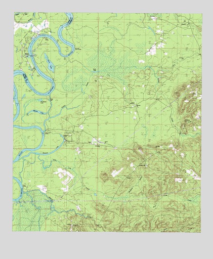
Tensaw, AL USGS Topographic Map
Click on map above to begin viewing in our Map Viewer.

This topographic map contains these locations and features:
Feature Name Type Latitude Longitude GNIS ID View Map
Antioch ChurchChurchN31.1755°W87.8142°134487View Map
Antioch SchoolSchoolN31.1752°W87.8150°113184View Map
Bengy LakeLakeN31.2452°W87.8658°113917View Map
Betts Lower LandingLocaleN31.2077°W87.8497°156061View Map
Boatyard LakeLakeN31.1721°W87.8464°114630View Map
Davis LandingLocaleN31.2399°W87.8453°156254View Map
Davis PlantationLocaleN31.2468°W87.8372°117138View Map
Dunn LakeLakeN31.2166°W87.8206°117679View Map
Englishs Landing (historical)LocaleN31.1368°W87.8389°149384View Map
Fort Mimms (historical)MilitaryN31.1792°W87.8389°1680868View Map
Fort Mimms ChurchChurchN31.1977°W87.7939°118522View Map
Fort Mimms Lookout TowerTowerN31.1882°W87.7575°134577View Map
Fort Montgomery (historical)MilitaryN31.2125°W87.8197°1680876View Map
Halls GutGutN31.2280°W87.8731°119601View Map
Harry Davis LandingLocaleN31.2407°W87.8458°133637View Map
Holley CreekStreamN31.1821°W87.8550°120247View Map
Holley Creek LandingLocaleN31.1813°W87.8544°134601View Map
La-Brooklyn ChurchChurchN31.2227°W87.7861°161677View Map
Little Zion ChurchChurchN31.1982°W87.7936°134619View Map
Majors CreekStreamN31.1477°W87.8683°152206View Map
Majors Creek SchoolSchoolN31.1302°W87.8317°122227View Map
McDonald LandingLocaleN31.2446°W87.8367°134628View Map
McDonald Lower LandingLocaleN31.2299°W87.8356°156684View Map
McDonalds Mill (historical)LocaleN31.1330°W87.8233°149400View Map
Middle LakeLakeN31.2499°W87.8683°122690View Map
Mimms LakeLakeN31.1932°W87.8556°122859View Map
Montgomery HillPopulated PlaceN31.1641°W87.7864°134636View Map
Montgomery Hill Baptist ChurchChurchN31.1635°W87.7869°152364View Map
Montgomery Hill LandingLocaleN31.1816°W87.8542°156729View Map
Mount Nebo Baptist ChurchChurchN31.1288°W87.8344°155350View Map
New Salem ChurchChurchN31.1735°W87.7805°134648View Map
Pine Log CreekStreamN31.1693°W87.8586°152930View Map
Saint Lukes ChurchChurchN31.1288°W87.8356°134695View Map
Saint Matthews ChurchChurchN31.1746°W87.8175°134698View Map
Silver LakeLakeN31.2207°W87.8510°126854View Map
Silver LandingLocaleN31.2330°W87.8478°157063View Map
Singleton LandingLocaleN31.2263°W87.8647°133708View Map
Singleton PlantationLocaleN31.2324°W87.8650°126900View Map
Slaughter BranchStreamN31.1471°W87.7983°126960View Map
South Carlton Oil FieldOilfieldN31.2293°W87.8667°133712View Map
Southfield LakeLakeN31.2001°W87.8572°127144View Map
Tate CemeteryCemeteryN31.2452°W87.7611°127703View Map
Tate SchoolSchoolN31.2368°W87.7558°127704View Map
TensawPopulated PlaceN31.1568°W87.7992°157149View Map
Tensaw ChurchChurchN31.1757°W87.8231°134727View Map
Tensaw Memorial CemeteryCemeteryN31.1979°W87.7944°134728View Map
Tensaw Volunteer Fire DepartmentBuildingN31.1758°W87.8161°2331020View Map
Turkey CreekStreamN31.2180°W87.8078°128151View Map
Wilsons Mill (historical)LocaleN31.2316°W87.7772°134746View Map
Wolf GutGutN31.2021°W87.8506°154017View Map

Note: Coordinates in the location and feature list above are referenced to NAD83 datum.


Copyright (C) 2008-2025 Ryan Niemi / Sunset Dynamics ... All Rights Reserved