TopoQuest Logo
Do you find TopoQuest useful?
Help keep TopoQuest running and adding new maps/features by donating!
Bitcoin:  19c7KJd3qBynnjoSw5npx9KScwjBe4ifkT
Litecoin:  LXs6TkuXGGXo1vDsWCkWVdjQX94eUKd6ui
Home View Maps Find Maps Find Places Resources & Links


Terrell South, Texas Topographic Map

USGS Map Title: Terrell South, TX
USGS Map MRC: 32096F3
DRG (GeoTIFF) Download: o32096f3.tif


Neighboring USGS Topographic Map Quads:


  Forney North, TX  
32096G4
 

  Terrell North, TX  
32096G3
 

  Poetry, TX  
32096G2
 

  Forney South, TX  
32096F4
 

  Terrell South, TX  
32096F3
 

  Elmo, TX  
32096F2
 

  Scurry, TX  
32096E4
 

  Kaufman, TX  
32096E3
 

  Ola, TX  
32096E2


Map MRC Location:

N33°
W97°
N33°
W96°
H8 H7 H6 H5 H4 H3 H2 H1
G8 G7 G6 G5 G4 G3 G2 G1
F8 F7 F6 F5 F4 F3 F2 F1
E8 E7 E6 E5 E4 E3 E2 E1
D8 D7 D6 D5 D4 D3 D2 D1
C8 C7 C6 C5 C4 C3 C2 C1
B8 B7 B6 B5 B4 B3 B2 B1
A8 A7 A6 A5 A4 A3 A2 A1
N32°
W97°
N32°
W96°

Terrell South, TX USGS 1:24K Topographic Map Preview:
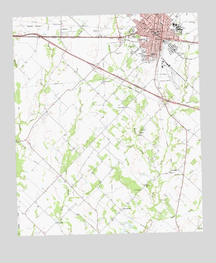
Terrell South, TX USGS Topographic Map
Click on map above to begin viewing in our Map Viewer.

This topographic map contains these locations and features:
Feature Name Type Latitude Longitude GNIS ID View Map
Alexander HospitalHospitalN32.7379°W96.2786°1329349View Map
Anthony BranchStreamN32.6529°W96.2783°1329585View Map
Bachelor CreekStreamN32.6587°W96.2789°1329901View Map
Barrow CemeteryCemeteryN32.7407°W96.2686°1330097View Map
Breezy HillSummitN32.7293°W96.2883°1331219View Map
Breezy Hill ParkParkN32.7287°W96.2866°2028720View Map
Burnett SchoolSchoolN32.7271°W96.2819°1331701View Map
CartwrightPopulated PlaceN32.6593°W96.2716°1378097View Map
Church of Christ Spanish ChurchChurchN32.7371°W96.2741°2022681View Map
City of TerrellCivilN32.7306°W96.2899°2412050View Map
Club LakeReservoirN32.6278°W96.2522°1333014View Map
College Street Learning CenterSchoolN32.7396°W96.2794°2007032View Map
Colonial HospitalHospitalN32.7401°W96.2816°1333134View Map
Eagans BranchStreamN32.6343°W96.2841°1334830View Map
Eagans CreekStreamN32.6974°W96.2622°1334831View Map
East Bachelor CemeteriesCemeteryN32.6846°W96.2897°1334876View Map
Easton CemeteryCemeteryN32.6435°W96.2750°1335047View Map
First National Bank BuildingBuildingN32.7365°W96.2769°2031205View Map
Flying G AirportAirportN32.6460°W96.3253°1386991View Map
Gill ParkParkN32.7426°W96.2941°2028248View Map
Hardin BranchStreamN32.7071°W96.2605°1337334View Map
Holy Temple Church of God in ChristChurchN32.7276°W96.2780°2022685View Map
John E Langwith Elementary SchoolSchoolN32.7440°W96.2766°2007042View Map
Kaufman Area Baptist ChurchChurchN32.7446°W96.2905°2022674View Map
Kaufman County Constable's Office Precinct 3BuildingN32.7382°W96.2730°2739107View Map
Kaufman County Emergency Services UnitBuildingN32.7350°W96.2783°2551574View Map
Kennedy Elementary SchoolSchoolN32.7190°W96.2836°2007050View Map
KTER-AM (Terrell)TowerN32.7432°W96.3053°1385704View Map
LawrencePopulated PlaceN32.7424°W96.3428°1374490View Map
Lechner FarmLocaleN32.7124°W96.3147°1339766View Map
Lone StarPopulated PlaceN32.6318°W96.3486°2034703View Map
Lone StarLocaleN32.6324°W96.3483°1340389View Map
Lone Star ChurchChurchN32.6521°W96.2880°1340395View Map
Matthew Cartwright HouseBuildingN32.7457°W96.2847°2030751View Map
Mount Calvary ChurchChurchN32.7440°W96.3289°1342018View Map
Mount Hebron ChurchChurchN32.6810°W96.2903°1342039View Map
New Hope Baptist ChurchChurchN32.7329°W96.2816°2022677View Map
New Oakwood CemeteryCemeteryN32.7279°W96.3064°1342498View Map
North Haven Construction Company LakeReservoirN32.7217°W96.3450°1860904View Map
North Haven Construction Company Lake DamDamN32.7218°W96.3453°1860903View Map
Oak RidgePopulated PlaceN32.6574°W96.2622°1388603View Map
Oakland CemeteryCemeteryN32.7374°W96.2933°1343019View Map
Oakwood CemeteryCemeteryN32.7315°W96.2944°1343043View Map
Post Oak BendPopulated PlaceN32.6385°W96.3050°1378902View Map
Post Oak Bend CemeteryCemeteryN32.6493°W96.2914°1344394View Map
Post Oak Bend CityPopulated PlaceN32.6321°W96.3136°1699808View Map
Renaissance HospitalHospitalN32.7107°W96.2789°2015803View Map
Rose Hill CemeteryCemeteryN32.6737°W96.3361°1345560View Map
S E Terrell CemeteryCemeteryN32.7271°W96.2653°1345796View Map
Southwestern Christian CollegeSchoolN32.7355°W96.2855°1347614View Map
State Hospital CemeteryCemeteryN32.7449°W96.2516°1347832View Map
TerrellPopulated PlaceN32.7360°W96.2753°1348380View Map
Terrell Adolescent CenterSchoolN32.7404°W96.2655°2007063View Map
Terrell Alternative SchoolSchoolN32.7390°W96.2944°2007064View Map
Terrell City HallBuildingN32.7376°W96.2755°2753609View Map
Terrell Community Hospital HeliportAirportN32.7093°W96.2789°1387630View Map
Terrell Fire Department Station 1BuildingN32.7378°W96.2755°2551556View Map
Terrell Fire Department Station 2BuildingN32.7190°W96.2818°2551513View Map
Terrell Heritage MuseumBuildingN32.7379°W96.2783°2014537View Map
Terrell Memorial StadiumParkN32.7399°W96.2947°2027675View Map
Terrell Municipal AirportAirportN32.7147°W96.2690°1387629View Map
Terrell Northeast Texas Medical Center Emergency Medical ServiceBuildingN32.7415°W96.2795°2656213View Map
Terrell Police DepartmentBuildingN32.7377°W96.2755°2738908View Map
Terrell Post OfficePost OfficeN32.7198°W96.2798°2732043View Map
Terrell Seventh Day Adventist ChurchChurchN32.7499°W96.2772°2022637View Map
Terrell Southeast Texas Medical Center Emergency Medical ServiceBuildingN32.7191°W96.2801°2656212View Map
Terrell State HospitalHospitalN32.7403°W96.2629°2718874View Map
Terrell Times Star BuildingBuildingN32.7360°W96.2775°2032556View Map
Terry CreekStreamN32.6901°W96.3711°1348385View Map
Town of Oak RidgeCivilN32.6256°W96.2518°2413065View Map
Town of Post Oak Bend CityCivilN32.6326°W96.3292°2412501View Map
Union ValleyPopulated PlaceN32.6974°W96.3005°1379195View Map
W H Burnett Elementary SchoolSchoolN32.7282°W96.2825°2007075View Map
Walnut CreekStreamN32.7260°W96.2583°1349432View Map
Warren-Crowell HouseBuildingN32.7476°W96.2869°2032469View Map
West End Church of ChristChurchN32.7343°W96.2869°2022683View Map
WilsonPopulated PlaceN32.6826°W96.2919°1379283View Map

Note: Coordinates in the location and feature list above are referenced to NAD83 datum.


Copyright (C) 2008-2025 Ryan Niemi / Sunset Dynamics ... All Rights Reserved