TopoQuest Logo
Do you find TopoQuest useful?
Help keep TopoQuest running and adding new maps/features by donating!
Bitcoin:  19c7KJd3qBynnjoSw5npx9KScwjBe4ifkT
Litecoin:  LXs6TkuXGGXo1vDsWCkWVdjQX94eUKd6ui
Home View Maps Find Maps Find Places Resources & Links


Thackerville, Oklahoma Topographic Map

USGS Map Title: Thackerville, OK
USGS Map MRC: 33097G2
DRG (GeoTIFF) Download: o33097g2.tif


Neighboring USGS Topographic Map Quads:


  Burneyville, OK  
33097H3
 

  Marietta West, OK  
33097H2
 

  Marietta East, OK  
33097H1
 

  Marysville, TX  
33097G3
 

  Thackerville, OK  
33097G2
 

  Horseshoe Bend, TX  
33097G1
 

  Muenster East, TX  
33097F3
 

  Gainesville North, TX  
33097F2
 

  Callisburg, TX  
33097F1


Map MRC Location:

N34°
W98°
N34°
W97°
H8 H7 H6 H5 H4 H3 H2 H1
G8 G7 G6 G5 G4 G3 G2 G1
F8 F7 F6 F5 F4 F3 F2 F1
E8 E7 E6 E5 E4 E3 E2 E1
D8 D7 D6 D5 D4 D3 D2 D1
C8 C7 C6 C5 C4 C3 C2 C1
B8 B7 B6 B5 B4 B3 B2 B1
A8 A7 A6 A5 A4 A3 A2 A1
N33°
W98°
N33°
W97°

Thackerville, OK USGS 1:24K Topographic Map Preview:
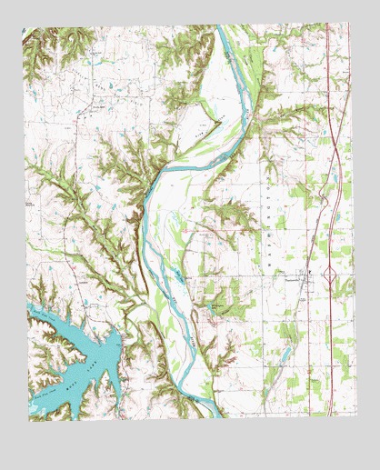
Thackerville, OK USGS Topographic Map
Click on map above to begin viewing in our Map Viewer.

This topographic map contains these locations and features:
Feature Name Type Latitude Longitude GNIS ID View Map
Bear Head CreekStreamN33.7895°W97.2072°1372444View Map
Bills CreekStreamN33.8709°W97.1647°1090140View Map
BomarPopulated PlaceN33.8595°W97.1270°1763676View Map
Brewster CreekStreamN33.7868°W97.2050°1372711View Map
Burk LakeLakeN33.7953°W97.1921°1090711View Map
Clouds BranchStreamN33.8445°W97.1642°1091482View Map
Dry Hollow CreekStreamN33.8709°W97.1533°1092252View Map
Fish CreekStreamN33.7604°W97.1928°1357350View Map
Fish Creek DamDamN33.7753°W97.2142°1357354View Map
Frog BottomBendN33.8420°W97.1717°1357774View Map
Gladney LakeReservoirN33.7700°W97.1521°1753442View Map
Gladney Lake DamDamN33.7684°W97.1536°1753441View Map
High Point CemeteryCemeteryN33.8565°W97.1914°1359184View Map
Hubert M Moss LakeReservoirN33.7674°W97.2312°1855379View Map
Mercy Health Love County AmbulanceBuildingN33.7573°W97.1317°2695872View Map
Moss Lake Volunteer Fire DepartmentBuildingN33.7811°W97.2271°2551746View Map
Mount Zion CemeteryCemeteryN33.8083°W97.1799°1095615View Map
North Fish CreekStreamN33.7709°W97.2236°1375160View Map
Old SloughGutN33.8659°W97.1670°1096251View Map
Sivells BendPopulated PlaceN33.8498°W97.2239°1380547View Map
Sivells Bend Oil FieldOilfieldN33.8540°W97.2178°1368353View Map
Sivells Bend SchoolSchoolN33.8665°W97.2239°1368354View Map
South Fish CreekStreamN33.7709°W97.2236°1376197View Map
ThackervillePopulated PlaceN33.7934°W97.1431°1098830View Map
Thackerville Community Volunteer Fire DepartmentBuildingN33.7950°W97.1430°2658584View Map
Thackerville Elementary SchoolSchoolN33.7956°W97.1425°1790716View Map
Thackerville High SchoolSchoolN33.7962°W97.1427°1790485View Map
Town of ThackervilleCivilN33.7934°W97.1426°2413381View Map
Township of WashingtonCivilN33.8084°W97.1308°1824718View Map
Wester CreekStreamN33.7726°W97.1861°1099626View Map
Whittington LakeReservoirN33.7852°W97.1807°1099745View Map
Whittington Lake DamDamN33.7868°W97.1820°1751376View Map
Whittington Ranch AirportAirportN33.7774°W97.1311°2717076View Map
Wolf Hollow CreekStreamN33.8412°W97.1661°1099966View Map

Note: Coordinates in the location and feature list above are referenced to NAD83 datum.


Copyright (C) 2008-2025 Ryan Niemi / Sunset Dynamics ... All Rights Reserved