TopoQuest Logo
Do you find TopoQuest useful?
Help keep TopoQuest running and adding new maps/features by donating!
Bitcoin:  19c7KJd3qBynnjoSw5npx9KScwjBe4ifkT
Litecoin:  LXs6TkuXGGXo1vDsWCkWVdjQX94eUKd6ui
Home View Maps Find Maps Find Places Resources & Links


Thatcher Mountain, Utah Topographic Map

USGS Map Title: Thatcher Mountain, UT
USGS Map MRC: 41112F3
DRG (GeoTIFF) Download: o41112f3.tif


Neighboring USGS Topographic Map Quads:


  Howell, UT  
41112G4
 

  Blind Springs, UT  
41112G3
 

  Riverside, UT  
41112G2
 

  Lampo Junction, UT  
41112F4
 

  Thatcher Mountain, UT  
41112F3
 

  Tremonton, UT  
41112F2
 

  Thatcher Mountain SW, UT  
41112E4


Map MRC Location:

N42°
W113°
N42°
W112°
H8 H7 H6 H5 H4 H3 H2 H1
G8 G7 G6 G5 G4 G3 G2 G1
F8 F7 F6 F5 F4 F3 F2 F1
E8 E7 E6 E5 E4 E3 E2 E1
D8 D7 D6 D5 D4 D3 D2 D1
C8 C7 C6 C5 C4 C3 C2 C1
B8 B7 B6 B5 B4 B3 B2 B1
A8 A7 A6 A5 A4 A3 A2 A1
N41°
W113°
N41°
W112°

Thatcher Mountain, UT USGS 1:24K Topographic Map Preview:
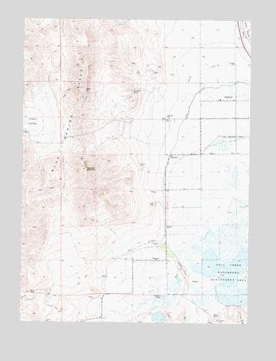
Thatcher Mountain, UT USGS Topographic Map
Click on map above to begin viewing in our Map Viewer.

This topographic map contains these locations and features:
Feature Name Type Latitude Longitude GNIS ID View Map
BothwellPopulated PlaceN41.7171°W112.2588°1425891View Map
Bothwell CemeteryCemeteryN41.7166°W112.2675°1437366View Map
Burnhope SpringSpringN41.7208°W112.3152°1426169View Map
Faust ValleyBasinN41.7071°W112.3736°1427894View Map
Jesses KnollSummitN41.6474°W112.2866°1429157View Map
PenrosePopulated PlaceN41.6508°W112.3016°1437656View Map
Penrose CemeteryCemeteryN41.6577°W112.3002°1431176View Map
Peterson PondReservoirN41.6354°W112.2972°1431192View Map
Poison SpringSpringN41.6276°W112.2676°1431362View Map
Salt Creek Waterfowl Management AreaParkN41.6449°W112.2536°1432136View Map
ThatcherPopulated PlaceN41.6938°W112.2941°1437700View Map
Thatcher - Penrose Fire Department and Water Service DistrictBuildingN41.6872°W112.2987°2627398View Map
Thatcher Census Designated PlaceCensusN41.6815°W112.3201°2584779View Map
Thatcher MountainSummitN41.6880°W112.3408°1433251View Map
Valleyview CemeteryCemeteryN41.7099°W112.2972°1433872View Map

Note: Coordinates in the location and feature list above are referenced to NAD83 datum.


Copyright (C) 2008-2025 Ryan Niemi / Sunset Dynamics ... All Rights Reserved