TopoQuest Logo
Do you find TopoQuest useful?
Help keep TopoQuest running and adding new maps/features by donating!
Bitcoin:  19c7KJd3qBynnjoSw5npx9KScwjBe4ifkT
Litecoin:  LXs6TkuXGGXo1vDsWCkWVdjQX94eUKd6ui
Home View Maps Find Maps Find Places Resources & Links


Tremonton, Utah Topographic Map

USGS Map Title: Tremonton, UT
USGS Map MRC: 41112F2
DRG (GeoTIFF) Download: o41112f2.tif


Neighboring USGS Topographic Map Quads:


  Blind Springs, UT  
41112G3
 

  Riverside, UT  
41112G2
 

  Cutler Dam, UT  
41112G1
 

  Thatcher Mountain, UT  
41112F3
 

  Tremonton, UT  
41112F2
 

  Honeyville, UT  
41112F1


  Brigham City, UT  
41112E1


Map MRC Location:

N42°
W113°
N42°
W112°
H8 H7 H6 H5 H4 H3 H2 H1
G8 G7 G6 G5 G4 G3 G2 G1
F8 F7 F6 F5 F4 F3 F2 F1
E8 E7 E6 E5 E4 E3 E2 E1
D8 D7 D6 D5 D4 D3 D2 D1
C8 C7 C6 C5 C4 C3 C2 C1
B8 B7 B6 B5 B4 B3 B2 B1
A8 A7 A6 A5 A4 A3 A2 A1
N41°
W113°
N41°
W112°

Tremonton, UT USGS 1:24K Topographic Map Preview:
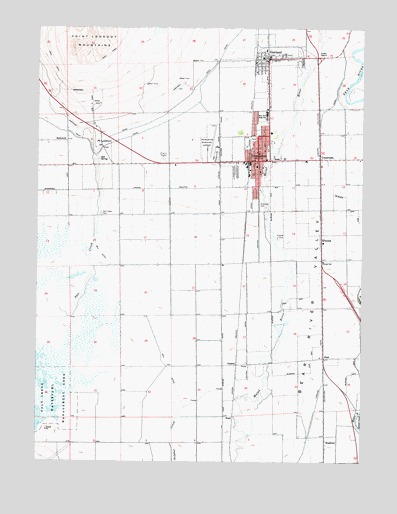
Tremonton, UT USGS Topographic Map
Click on map above to begin viewing in our Map Viewer.

This topographic map contains these locations and features:
Feature Name Type Latitude Longitude GNIS ID View Map
Bear River High SchoolSchoolN41.7245°W112.1628°1425358View Map
Bear River Middle SchoolSchoolN41.7255°W112.1592°1435093View Map
Bear River Valley HeliportAirportN41.7183°W112.1708°1435099View Map
Bear River Valley HospitalHospitalN41.7243°W112.1824°1448118View Map
BradfordPopulated PlaceN41.6299°W112.1397°1437511View Map
BushLocaleN41.6549°W112.1405°1426212View Map
Central CanalCanalN41.6727°W112.1697°1426507View Map
City of GarlandCivilN41.7363°W112.1628°2410573View Map
City of TremontonCivilN41.7188°W112.1890°2412091View Map
Corinne CanalCanalN41.6760°W112.1413°1439952View Map
CropleyPopulated PlaceN41.6530°W112.1736°1437537View Map
CrossroadsPopulated PlaceN41.7124°W112.1422°1427117View Map
Doutres Mobile Home ParkLocaleN41.7144°W112.1705°1435443View Map
ElwoodPopulated PlaceN41.6905°W112.1411°1427809View Map
Elwood CemeteryCemeteryN41.6897°W112.1588°1427810View Map
Elwood SchoolSchoolN41.6827°W112.1405°1427811View Map
GarlandPopulated PlaceN41.7410°W112.1616°1428146View Map
Garland Fire DepartmentBuildingN41.7417°W112.1623°2627171View Map
Garland Police DepartmentBuildingN41.7418°W112.1622°2730422View Map
Garland Post OfficePost OfficeN41.7414°W112.1629°1455287View Map
Highline CanalCanalN41.7269°W112.2486°1428712View Map
Jack's Airport (historical)AirportN41.7337°W112.1955°1434600View Map
KBXN-AM (Tremonton)TowerN41.7260°W112.2100°1455768View Map
McKinley Elementary SchoolSchoolN41.7059°W112.1679°1436019View Map
Mill DitchCanalN41.6524°W112.2002°1430326View Map
North Park Elementary SchoolSchoolN41.7212°W112.1661°1436046View Map
Point LookoutCliffN41.7155°W112.2277°1431354View Map
Point Lookout MountainsSummitN41.7480°W112.2280°1431356View Map
Riverview CemeteryCemeteryN41.6977°W112.1629°1431864View Map
Salt CreekStreamN41.6555°W112.2500°1432133View Map
Salt Creek CemeteryCemeteryN41.6963°W112.2261°1432135View Map
Salt SpringSpringN41.7117°W112.2282°1432143View Map
The Church of Jesus Christ of Latter Day SaintsChurchN41.7416°W112.1644°1436908View Map
The Church of Jesus Christ of Latter Day SaintsChurchN41.7088°W112.1655°1437108View Map
The Church of Jesus Christ of Latter Day SaintsChurchN41.7199°W112.1613°1437109View Map
The Church of Jesus Christ of Latter Day SaintsChurchN41.7138°W112.1491°1437110View Map
The Church of Jesus Christ of Latter Day SaintsChurchN41.6933°W112.1650°1437111View Map
Town of ElwoodCivilN41.6758°W112.1376°2412482View Map
TremontonPopulated PlaceN41.7119°W112.1655°1433664View Map
Tremonton Fire DepartmentBuildingN41.7107°W112.1671°2627178View Map
Tremonton Police DepartmentBuildingN41.7103°W112.1671°2730340View Map
Tremonton Post OfficePost OfficeN41.7103°W112.1657°1455554View Map

Note: Coordinates in the location and feature list above are referenced to NAD83 datum.


Copyright (C) 2008-2025 Ryan Niemi / Sunset Dynamics ... All Rights Reserved