TopoQuest Logo
Do you find TopoQuest useful?
Help keep TopoQuest running and adding new maps/features by donating!
Bitcoin:  19c7KJd3qBynnjoSw5npx9KScwjBe4ifkT
Litecoin:  LXs6TkuXGGXo1vDsWCkWVdjQX94eUKd6ui
Home View Maps Find Maps Find Places Resources & Links


The Sinks, Missouri Topographic Map

USGS Map Title: The Sinks, MO
USGS Map MRC: 37091C3
DRG (GeoTIFF) Download: o37091c3.tif


Neighboring USGS Topographic Map Quads:


  Gladden, MO  
37091D4
 

  Loggers Lake, MO  
37091D3
 

  Bunker, MO  
37091D2
 

  Round Spring, MO  
37091C4
 

  The Sinks, MO  
37091C3
 

  Midridge, MO  
37091C2
 

  Alley Spring, MO  
37091B4
 

  Eminence, MO  
37091B3
 

  Powder Mill Ferry, MO  
37091B2


Map MRC Location:

N38°
W92°
N38°
W91°
H8 H7 H6 H5 H4 H3 H2 H1
G8 G7 G6 G5 G4 G3 G2 G1
F8 F7 F6 F5 F4 F3 F2 F1
E8 E7 E6 E5 E4 E3 E2 E1
D8 D7 D6 D5 D4 D3 D2 D1
C8 C7 C6 C5 C4 C3 C2 C1
B8 B7 B6 B5 B4 B3 B2 B1
A8 A7 A6 A5 A4 A3 A2 A1
N37°
W92°
N37°
W91°

The Sinks, MO USGS 1:24K Topographic Map Preview:
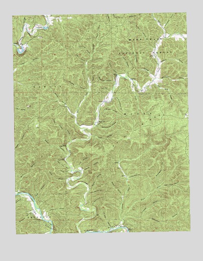
The Sinks, MO USGS Topographic Map
Click on map above to begin viewing in our Map Viewer.

This topographic map contains these locations and features:
Feature Name Type Latitude Longitude GNIS ID View Map
Bald KnobSummitN37.3395°W91.3032°748649View Map
Baldknob HollowValleyN37.3350°W91.3029°748656View Map
Barn HollowValleyN37.2742°W91.3732°748672View Map
Bee BluffCliffN37.2517°W91.2949°748758View Map
Ben HollowValleyN37.3353°W91.2740°748781View Map
Big Creek School (historical)SchoolN37.2634°W91.3179°747882View Map
Birdie HollowValleyN37.3178°W91.3140°748869View Map
Brushy CreekStreamN37.2528°W91.3004°749061View Map
Brushy Mill (historical)Populated PlaceN37.2812°W91.2940°739913View Map
Brushy Post Office (historical)Post OfficeN37.2862°W91.2990°760065View Map
Bryant HollowValleyN37.2698°W91.2990°749077View Map
Buffington HollowValleyN37.2764°W91.2721°749101View Map
Button Rock HollowValleyN37.3378°W91.2712°749141View Map
Cabin HollowValleyN37.2592°W91.3537°749150View Map
Camden HollowValleyN37.3548°W91.2735°749166View Map
Canoe HollowValleyN37.2723°W91.3707°749197View Map
Cedar Hill SchoolSchoolN37.3114°W91.3162°747881View Map
Cedar House HollowValleyN37.3031°W91.3349°749306View Map
Charles HollowValleyN37.2859°W91.3265°749332View Map
Conway CemeteryCemeteryN37.3692°W91.2673°754374View Map
Deer Lick HollowValleyN37.2864°W91.3357°749608View Map
Dry CreekStreamN37.3373°W91.2912°749708View Map
Dugan HollowValleyN37.2942°W91.3385°749743View Map
Field HollowValleyN37.2875°W91.3290°749917View Map
George Hellmuth Lower DamDamN37.3567°W91.3718°763606View Map
George Hellmuth Lower LakeReservoirN37.3576°W91.3724°763607View Map
George Hellmuth Upper DamDamN37.3550°W91.3685°764960View Map
George Hellmuth Upper LakeReservoirN37.3556°W91.3681°764961View Map
Graveyard HollowValleyN37.3662°W91.2668°750120View Map
Heaton CemeteryCemeteryN37.3162°W91.3324°750276View Map
Henhouse HollowValleyN37.3512°W91.3196°750292View Map
Hog Cave HollowValleyN37.2756°W91.2707°750355View Map
Hog HollowValleyN37.3475°W91.3235°750358View Map
House HollowValleyN37.2859°W91.3362°750406View Map
Kates HollowValleyN37.3053°W91.3199°750559View Map
Lewis HollowValleyN37.3406°W91.2946°750690View Map
Little Renfro HollowValleyN37.2728°W91.3229°750794View Map
Low GapGapN37.2600°W91.3157°750873View Map
Low Gap HollowValleyN37.2528°W91.3068°750877View Map
Lower Dugan BluffCliffN37.2923°W91.3396°750882View Map
Lower Schoolhouse HollowValleyN37.2639°W91.3187°750887View Map
Mash CreekStreamN37.3084°W91.3260°750957View Map
Mauser MillPopulated PlaceN37.3128°W91.3151°750968View Map
Medley HollowValleyN37.3403°W91.3007°751017View Map
Middle Prong Brushy CreekStreamN37.2559°W91.2982°751042View Map
Mill CreekStreamN37.3606°W91.2660°751068View Map
Mullins HollowValleyN37.3314°W91.3221°751231View Map
Nellie Right HollowValleyN37.3695°W91.3660°751273View Map
Old Schoolhouse HollowValleyN37.3273°W91.3043°751426View Map
Polk RidgeRidgeN37.3164°W91.2676°751691View Map
Pond HollowValleyN37.2817°W91.3374°751698View Map
Randolph HollowValleyN37.2623°W91.3626°751807View Map
Rat SchoolSchoolN37.3625°W91.2618°747880View Map
Renfro HollowValleyN37.2745°W91.3221°751854View Map
Root HollowValleyN37.2692°W91.3610°751961View Map
Saltpeter HollowValleyN37.3389°W91.2751°752017View Map
Satterfield HollowValleyN37.2581°W91.2862°752037View Map
Schoolhouse HollowValleyN37.3114°W91.3160°752048View Map
Terrill HollowValleyN37.3606°W91.3149°752513View Map
The Emerald GrottoArchN37.3583°W91.3708°2680497View Map
The SinksBasinN37.3575°W91.3718°752524View Map
Tomahawk HollowValleyN37.3462°W91.2699°752556View Map
Turkey Roost HollowValleyN37.2800°W91.2949°752610View Map
Turkeypen HollowValleyN37.2581°W91.2862°752613View Map
Upper Dugan BluffCliffN37.3003°W91.3382°752674View Map
Warren HollowValleyN37.3175°W91.3318°752764View Map
Wet HollowValleyN37.3306°W91.3068°752837View Map
White Oak ForestWoodsN37.2573°W91.3493°753126View Map

Note: Coordinates in the location and feature list above are referenced to NAD83 datum.


Copyright (C) 2008-2025 Ryan Niemi / Sunset Dynamics ... All Rights Reserved