TopoQuest Logo
Do you find TopoQuest useful?
Help keep TopoQuest running and adding new maps/features by donating!
Bitcoin:  19c7KJd3qBynnjoSw5npx9KScwjBe4ifkT
Litecoin:  LXs6TkuXGGXo1vDsWCkWVdjQX94eUKd6ui
Home View Maps Find Maps Find Places Resources & Links


Loggers Lake, Missouri Topographic Map

USGS Map Title: Loggers Lake, MO
USGS Map MRC: 37091D3
DRG (GeoTIFF) Download: o37091d3.tif


Neighboring USGS Topographic Map Quads:


  Doss, MO  
37091E4
 

  Stone Hill, MO  
37091E3
 

  Greeley, MO  
37091E2
 

  Gladden, MO  
37091D4
 

  Loggers Lake, MO  
37091D3
 

  Bunker, MO  
37091D2
 

  Round Spring, MO  
37091C4
 

  The Sinks, MO  
37091C3
 

  Midridge, MO  
37091C2


Map MRC Location:

N38°
W92°
N38°
W91°
H8 H7 H6 H5 H4 H3 H2 H1
G8 G7 G6 G5 G4 G3 G2 G1
F8 F7 F6 F5 F4 F3 F2 F1
E8 E7 E6 E5 E4 E3 E2 E1
D8 D7 D6 D5 D4 D3 D2 D1
C8 C7 C6 C5 C4 C3 C2 C1
B8 B7 B6 B5 B4 B3 B2 B1
A8 A7 A6 A5 A4 A3 A2 A1
N37°
W92°
N37°
W91°

Loggers Lake, MO USGS 1:24K Topographic Map Preview:
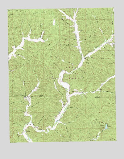
Loggers Lake, MO USGS Topographic Map
Click on map above to begin viewing in our Map Viewer.

This topographic map contains these locations and features:
Feature Name Type Latitude Longitude GNIS ID View Map
Aunt Sal HollowValleyN37.3867°W91.3235°748626View Map
Backbone HollowValleyN37.4067°W91.3535°748633View Map
Bacon HollowValleyN37.4778°W91.2918°748634View Map
Barren Fork HollowValleyN37.4639°W91.2932°748689View Map
Barxtel HollowValleyN37.4167°W91.3532°748699View Map
Bay CemeteryCemeteryN37.4089°W91.3104°748717View Map
Bay HollowValleyN37.4642°W91.3601°748720View Map
Bear Pen HollowValleyN37.4695°W91.2610°748739View Map
Big HollowValleyN37.3887°W91.3596°748840View Map
Black Henry HollowValleyN37.4637°W91.2640°748879View Map
Boardinghouse HollowValleyN37.3912°W91.3101°748947View Map
Brooks PondLakeN37.4992°W91.3749°749033View Map
Burrus HollowValleyN37.4153°W91.3518°749130View Map
Burrus HollowValleyN37.4503°W91.2865°749131View Map
Cave Branch HollowValleyN37.4081°W91.3115°749258View Map
Cave Spring SchoolSchoolN37.3859°W91.3596°747869View Map
Chatman CemeteryCemeteryN37.4656°W91.2526°749335View Map
Chatman HollowValleyN37.4675°W91.2585°749336View Map
Copeland HollowValleyN37.4734°W91.3518°749468View Map
Dead Horse HollowValleyN37.4714°W91.2949°749597View Map
Delmar CemeteryCemeteryN37.3850°W91.3560°749621View Map
Delmar School (historical)SchoolN37.3953°W91.3165°747871View Map
Dennie HollowValleyN37.3775°W91.2762°749626View Map
Falk Mill (historical)Populated PlaceN37.4395°W91.3010°739911View Map
Falk Mill HollowValleyN37.4400°W91.3001°749896View Map
Flat HollowValleyN37.4920°W91.3015°749937View Map
GilaPopulated PlaceN37.4303°W91.3079°740449View Map
Gordon CreekStreamN37.4509°W91.2879°750086View Map
Gordon HollowValleyN37.4745°W91.2524°750087View Map
Hanning CemeteryCemeteryN37.4528°W91.2826°750218View Map
HardageLocaleN37.3884°W91.3265°753096View Map
Hellums HollowValleyN37.4475°W91.3001°750284View Map
Hickory HollowValleyN37.4077°W91.3543°750312View Map
Highley SpringSpringN37.4231°W91.2685°750321View Map
Hulsey HollowValleyN37.4720°W91.3565°750418View Map
Hulsey School (historical)SchoolN37.4612°W91.3610°735473View Map
Improvement HollowValleyN37.4223°W91.2696°750445View Map
Little CreekStreamN37.3939°W91.3504°750758View Map
Little Sinking CreekStreamN37.4167°W91.3054°750801View Map
Loggers LakeReservoirN37.3884°W91.2616°758306View Map
Loggers Lake CampgroundLocaleN37.3900°W91.2640°754376View Map
Loggers Lake DamDamN37.3867°W91.2635°763558View Map
Middle HollowValleyN37.3773°W91.2782°751040View Map
Minninghaw HollowValleyN37.4717°W91.3368°751122View Map
Nash HollowValleyN37.4581°W91.3687°751261View Map
Parks HollowValleyN37.4834°W91.2960°751504View Map
Pea Vine HollowValleyN37.4025°W91.3557°751525View Map
Red Hill HollowValleyN37.4756°W91.2524°751834View Map
Ritter HollowValleyN37.4887°W91.2960°751892View Map
Roney HollowValleyN37.4664°W91.2540°751959View Map
Savage HollowValleyN37.4550°W91.2804°752039View Map
Schoolhouse HollowValleyN37.3895°W91.3446°752050View Map
Schoolhouse HollowValleyN37.4639°W91.3674°752051View Map
Sinkin Experimental ForestParkN37.4873°W91.2690°754375View Map
Smokehouse HollowValleyN37.3770°W91.2762°752226View Map
Spring HollowValleyN37.4428°W91.2926°752316View Map
Stephens HollowValleyN37.4681°W91.2918°752354View Map
Sugar Tree Grove School (historical)SchoolN37.4534°W91.2893°747870View Map
Sugar Tree Grove SpringSpringN37.4531°W91.2868°752417View Map
Swiney CemeteryCemeteryN37.4214°W91.2987°752469View Map
Thompson HollowValleyN37.3937°W91.3171°752532View Map
Township of SinkingCivilN37.4608°W91.3191°766608View Map
Turkey Roost HollowValleyN37.4064°W91.3079°752611View Map

Note: Coordinates in the location and feature list above are referenced to NAD83 datum.


Copyright (C) 2008-2025 Ryan Niemi / Sunset Dynamics ... All Rights Reserved