TopoQuest Logo
Do you find TopoQuest useful?
Help keep TopoQuest running and adding new maps/features by donating!
Bitcoin:  19c7KJd3qBynnjoSw5npx9KScwjBe4ifkT
Litecoin:  LXs6TkuXGGXo1vDsWCkWVdjQX94eUKd6ui
Home View Maps Find Maps Find Places Resources & Links


Thorndale, Texas Topographic Map

USGS Map Title: Thorndale, TX
USGS Map MRC: 30097E2
DRG (GeoTIFF) Download: o30097e2.tif


Neighboring USGS Topographic Map Quads:


  Granger Lake, TX  
30097F3
 

  San Gabriel, TX  
30097F2
 

  Rockdale West, TX  
30097F1
 

  Thrall, TX  
30097E3
 

  Thorndale, TX  
30097E2
 

  Alcoa Lake, TX  
30097E1
 

  Structure, TX  
30097D3
 

  Beaukiss, TX  
30097D2
 

  Lexington, TX  
30097D1


Map MRC Location:

N31°
W98°
N31°
W97°
H8 H7 H6 H5 H4 H3 H2 H1
G8 G7 G6 G5 G4 G3 G2 G1
F8 F7 F6 F5 F4 F3 F2 F1
E8 E7 E6 E5 E4 E3 E2 E1
D8 D7 D6 D5 D4 D3 D2 D1
C8 C7 C6 C5 C4 C3 C2 C1
B8 B7 B6 B5 B4 B3 B2 B1
A8 A7 A6 A5 A4 A3 A2 A1
N30°
W98°
N30°
W97°

Thorndale, TX USGS 1:24K Topographic Map Preview:
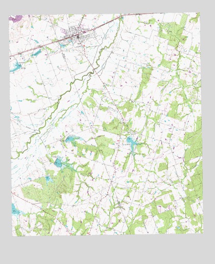
Thorndale, TX USGS Topographic Map
Click on map above to begin viewing in our Map Viewer.

This topographic map contains these locations and features:
Feature Name Type Latitude Longitude GNIS ID View Map
Berry BranchStreamN30.6071°W97.1917°1351916View Map
City Lake Number 1 DamDamN30.6052°W97.2303°1856868View Map
City Lake Number OneReservoirN30.6036°W97.2319°1856869View Map
City Lake Number TwoReservoirN30.6077°W97.2150°1354529View Map
City of ThorndaleCivilN30.6141°W97.2067°2412063View Map
Connell CemeteryCemeteryN30.5619°W97.1864°2043307View Map
ConoleyPopulated PlaceN30.5583°W97.1708°1379587View Map
Conoley Union Community CemeteryCemeteryN30.5586°W97.1765°2043308View Map
Holynok CreekStreamN30.5833°W97.1997°1359478View Map
Jackson LakeLakeN30.6104°W97.2103°1360112View Map
Little Sandy CreekStreamN30.5202°W97.1386°1361462View Map
Long BranchStreamN30.5630°W97.2225°1361689View Map
Long BranchStreamN30.5599°W97.2317°1361706View Map
Pleasant Retreat CemeteryCemeteryN30.5263°W97.1742°2043309View Map
Pleasant Retreat ChurchChurchN30.5269°W97.1736°1365442View Map
Ramseur CemeteryCemeteryN30.5552°W97.2169°1365981View Map
Saint John ChurchChurchN30.6166°W97.2144°1367170View Map
Saint Paul Lutheran CemeteryCemeteryN30.6135°W97.2139°2043306View Map
SaltyPopulated PlaceN30.5935°W97.1328°1380485View Map
Salty CemeteryCemeteryN30.5952°W97.1325°2042806View Map
Schoolhouse BranchStreamN30.5916°W97.1961°1367845View Map
Site Number TwentyReservoirN30.5969°W97.2430°1368337View Map
Site Number TwentyfourReservoirN30.5549°W97.1736°1368341View Map
Site Number TwentyoneReservoirN30.5338°W97.2269°1368338View Map
Site Number TwentythreeReservoirN30.5552°W97.2133°1368340View Map
Site Number TwentytwoReservoirN30.5424°W97.2208°1368339View Map
Soil Conservation Service Site 20 DamDamN30.5969°W97.2436°1856860View Map
Soil Conservation Service Site 20 ReservoirReservoirN30.5961°W97.2441°1856861View Map
Soil Conservation Service Site 21 DamDamN30.5335°W97.2269°1856862View Map
Soil Conservation Service Site 21 ReservoirReservoirN30.5328°W97.2264°1856863View Map
Soil Conservation Service Site 22 DamDamN30.5419°W97.2219°1856864View Map
Soil Conservation Service Site 22 ReservoirReservoirN30.5413°W97.2194°1856865View Map
Soil Conservation Service Site 23 DamDamN30.5552°W97.2136°1856866View Map
Soil Conservation Service Site 23 ReservoirReservoirN30.5547°W97.2117°1856867View Map
Soil Conservation Service Site 24 DamDamN30.5552°W97.1736°1858936View Map
Soil Conservation Service Site 24 ReservoirReservoirN30.5531°W97.1721°1858937View Map
Thomson Chapel CemeteryCemeteryN30.5841°W97.1267°2043285View Map
ThorndalePopulated PlaceN30.6138°W97.2055°1369864View Map
Thorndale CemeteryCemeteryN30.6235°W97.2119°1369865View Map
Thorndale DivisionCivilN30.5950°W97.1394°1939261View Map
Thorndale Municipal BuildingBuildingN30.6143°W97.2063°2753961View Map
Thorndale Police DepartmentBuildingN30.6143°W97.2063°2739323View Map
Thorndale Post OfficePost OfficeN30.6141°W97.2074°2731718View Map
Thorndale Volunteer Emergency Medical ServicesBuildingN30.6140°W97.2062°2655755View Map
Thorndale Volunteer Fire DepartmentBuildingN30.6143°W97.2063°2552635View Map

Note: Coordinates in the location and feature list above are referenced to NAD83 datum.


Copyright (C) 2008-2025 Ryan Niemi / Sunset Dynamics ... All Rights Reserved