TopoQuest Logo
Do you find TopoQuest useful?
Help keep TopoQuest running and adding new maps/features by donating!
Bitcoin:  19c7KJd3qBynnjoSw5npx9KScwjBe4ifkT
Litecoin:  LXs6TkuXGGXo1vDsWCkWVdjQX94eUKd6ui
Home View Maps Find Maps Find Places Resources & Links


Tipton Ford, Missouri Topographic Map

USGS Map Title: Tipton Ford, MO
USGS Map MRC: 36094H4
DRG (GeoTIFF) Download: o36094h4.tif


Neighboring USGS Topographic Map Quads:


  Joplin West, MO  
37094A5
 

  Joplin East, MO  
37094A4
 

  Fidelity, MO  
37094A3
 

  Racine, MO  
36094H5
 

  Tipton Ford, MO  
36094H4
 

  Granby, MO  
36094H3
 

  Seneca, MO  
36094G5
 

  Neosho West, MO  
36094G4
 

  Neosho East, MO  
36094G3


Map MRC Location:

N37°
W95°
N37°
W94°
H8 H7 H6 H5 H4 H3 H2 H1
G8 G7 G6 G5 G4 G3 G2 G1
F8 F7 F6 F5 F4 F3 F2 F1
E8 E7 E6 E5 E4 E3 E2 E1
D8 D7 D6 D5 D4 D3 D2 D1
C8 C7 C6 C5 C4 C3 C2 C1
B8 B7 B6 B5 B4 B3 B2 B1
A8 A7 A6 A5 A4 A3 A2 A1
N36°
W95°
N36°
W94°

Tipton Ford, MO USGS 1:24K Topographic Map Preview:
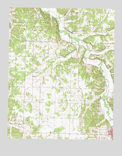
Tipton Ford, MO USGS Topographic Map
Click on map above to begin viewing in our Map Viewer.

This topographic map contains these locations and features:
Feature Name Type Latitude Longitude GNIS ID View Map
AlcoraLocaleN36.9242°W94.4438°746334View Map
Baynham BranchStreamN36.9626°W94.4063°713760View Map
Black Jack School (historical)SchoolN36.9678°W94.4808°746326View Map
Brock PrairieAreaN36.8815°W94.4442°729849View Map
Burkhart PrairieAreaN36.9617°W94.4830°729853View Map
Carver BranchStreamN36.9717°W94.4227°729855View Map
Cave Spring ChurchChurchN36.9245°W94.4397°715544View Map
Cave Spring School (historical)SchoolN36.9337°W94.4441°746333View Map
Cedar CreekStreamN36.9684°W94.4183°715579View Map
Cedar Creek CemeteryCemeteryN36.9545°W94.4383°715590View Map
Cedar Creek ChurchChurchN36.9603°W94.4347°715591View Map
Cedar Creek School (historical)SchoolN36.9557°W94.4397°746331View Map
FredvillePopulated PlaceN36.9095°W94.4127°718190View Map
Hammers School (historical)SchoolN36.8948°W94.4263°746335View Map
Hill Dale School (historical)SchoolN36.9456°W94.3755°746332View Map
Hilldale ChurchChurchN36.9448°W94.3766°719615View Map
Kenney Memorial CemeteryCemeteryN36.9201°W94.3758°720541View Map
King CemeteryCemeteryN36.8995°W94.4455°720607View Map
Mormon ChurchChurchN36.8798°W94.3969°722624View Map
Oak Dale School (historical)SchoolN36.9815°W94.3827°746330View Map
Oak Grove ChapelChurchN36.9690°W94.4805°723571View Map
Oak Grove ChurchChurchN36.9787°W94.4711°723578View Map
Oak Grove School (historical)SchoolN36.9609°W94.4716°746327View Map
Pleasant Hill CemeteryCemeteryN36.9067°W94.3999°724515View Map
Redings Mill Fire Protection District Station 4BuildingN36.9658°W94.4237°2621332View Map
Schoenborn School (historical)SchoolN36.9030°W94.4623°746328View Map
Spring Valley ChurchChurchN36.9787°W94.4116°726950View Map
Spring Valley School (historical)SchoolN36.9780°W94.4144°746329View Map
SpurgeonPopulated PlaceN36.9345°W94.4716°726971View Map
Spurgeon PrairieAreaN36.9262°W94.4719°726973View Map
Spurgeon SchoolSchoolN36.9390°W94.4722°745840View Map
Thrasher CemeteryCemeteryN36.9245°W94.4452°727627View Map
Tipton FordPopulated PlaceN36.9767°W94.4261°741324View Map
Township of NeoshoCivilN36.9045°W94.4013°767078View Map
Wildwood ChurchChurchN36.9962°W94.4211°728848View Map

Note: Coordinates in the location and feature list above are referenced to NAD83 datum.


Copyright (C) 2008-2025 Ryan Niemi / Sunset Dynamics ... All Rights Reserved