TopoQuest Logo
Do you find TopoQuest useful?
Help keep TopoQuest running and adding new maps/features by donating!
Bitcoin:  19c7KJd3qBynnjoSw5npx9KScwjBe4ifkT
Litecoin:  LXs6TkuXGGXo1vDsWCkWVdjQX94eUKd6ui
Home View Maps Find Maps Find Places Resources & Links


Seneca, Missouri Topographic Map

USGS Map Title: Seneca, MO
USGS Map MRC: 36094G5
DRG (GeoTIFF) Download: o36094g5.tif


Neighboring USGS Topographic Map Quads:


  Peoria, OK  
36094H6
 

  Racine, MO  
36094H5
 

  Tipton Ford, MO  
36094H4
 

  Wyandotte, OK  
36094G6
 

  Seneca, MO  
36094G5
 

  Neosho West, MO  
36094G4
 

  Cayuga, OK  
36094F6
 

  Tiff City, MO  
36094F5
 

  Anderson, MO  
36094F4


Map MRC Location:

N37°
W95°
N37°
W94°
H8 H7 H6 H5 H4 H3 H2 H1
G8 G7 G6 G5 G4 G3 G2 G1
F8 F7 F6 F5 F4 F3 F2 F1
E8 E7 E6 E5 E4 E3 E2 E1
D8 D7 D6 D5 D4 D3 D2 D1
C8 C7 C6 C5 C4 C3 C2 C1
B8 B7 B6 B5 B4 B3 B2 B1
A8 A7 A6 A5 A4 A3 A2 A1
N36°
W95°
N36°
W94°

Seneca, MO USGS 1:24K Topographic Map Preview:
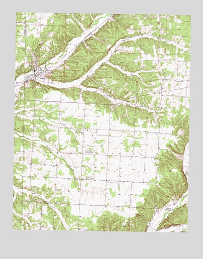
Seneca, MO USGS Topographic Map
Click on map above to begin viewing in our Map Viewer.

This topographic map contains these locations and features:
Feature Name Type Latitude Longitude GNIS ID View Map
Charleton HollowValleyN36.7506°W94.5074°715744View Map
City of SenecaCivilN36.8445°W94.6092°2396574View Map
DessaPopulated PlaceN36.8070°W94.5216°716852View Map
Gallemore School (historical)SchoolN36.8587°W94.5763°729893View Map
Graves CemeteryCemeteryN36.8614°W94.5210°718748View Map
Hickory Grove School (historical)SchoolN36.8051°W94.5580°729903View Map
Hollow Springs ChurchChurchN36.8053°W94.5763°719719View Map
Little Lost CreekStreamN36.8395°W94.6183°721264View Map
Lost Creek Watershed Structure D-1 DamDamN36.8201°W94.5202°763555View Map
MacDougal BranchStreamN36.8356°W94.5844°721708View Map
MayPopulated PlaceN36.7512°W94.5222°741047View Map
May School (historical)SchoolN36.7517°W94.5219°746448View Map
Newton County Structure F-1 DamDamN36.8634°W94.6036°763402View Map
Newton County Structure F-2 DamDamN36.8501°W94.6069°763404View Map
Newton County Structure F-3 DamDamN36.8534°W94.6119°763406View Map
Number Four School (historical)SchoolN36.8599°W94.5119°2709565View Map
Number One School (historical)SchoolN36.7870°W94.5949°723542View Map
Number Two School (historical)SchoolN36.8236°W94.5933°2709564View Map
SenecaPopulated PlaceN36.8415°W94.6111°726201View Map
Seneca Area Fire Protection District Station 2 DessaBuildingN36.8055°W94.5213°2621514View Map
Seneca CemeteryCemeteryN36.8473°W94.6176°2702578View Map
Seneca Elementary SchoolSchoolN36.8367°W94.6027°2709527View Map
Seneca Fire DepartmentBuildingN36.8388°W94.6122°2620841View Map
Seneca High SchoolSchoolN36.8378°W94.6063°2709530View Map
Seneca Intermediate SchoolSchoolN36.8357°W94.6023°2709528View Map
Seneca Junior High SchoolSchoolN36.8401°W94.6097°2709529View Map
Seneca Police DepartmentBuildingN36.8387°W94.6121°2752466View Map
Seneca Post OfficePost OfficeN36.8404°W94.6109°2782946View Map
Structure F-1 ReservoirReservoirN36.8634°W94.6036°763403View Map
Structure F-2 ReservoirReservoirN36.8501°W94.6069°763405View Map
Structure F-3 ReservoirReservoirN36.8534°W94.6119°763407View Map
Swars PrairieAreaN36.7912°W94.5553°727364View Map
Swars Prairie Baptist ChurchChurchN36.7798°W94.5691°727365View Map
Swars Prairie Church of ChristChurchN36.7948°W94.5711°727366View Map
Thompson Grove School (historical)SchoolN36.7778°W94.5494°727604View Map
Township of BuffaloCivilN36.7980°W94.5191°767072View Map
Township of SenecaCivilN36.8733°W94.5844°767080View Map
Wela ParkPopulated PlaceN36.8745°W94.5555°728482View Map
West SenecaPopulated PlaceN36.8367°W94.6199°1763738View Map
WestviewPopulated PlaceN36.8370°W94.5202°728657View Map
Westview Elementary SchoolSchoolN36.8373°W94.5105°728658View Map
Wilson CemeteryCemeteryN36.8214°W94.5205°728958View Map

Note: Coordinates in the location and feature list above are referenced to NAD83 datum.


Copyright (C) 2008-2024 Ryan Niemi / Sunset Dynamics ... All Rights Reserved