TopoQuest Logo
Do you find TopoQuest useful?
Help keep TopoQuest running and adding new maps/features by donating!
Bitcoin:  19c7KJd3qBynnjoSw5npx9KScwjBe4ifkT
Litecoin:  LXs6TkuXGGXo1vDsWCkWVdjQX94eUKd6ui
Home View Maps Find Maps Find Places Resources & Links


Toro Peak, California Topographic Map

USGS Map Title: Toro Peak, CA
USGS Map MRC: 33116E4
DRG (GeoTIFF) Download: o33116e4.tif


Neighboring USGS Topographic Map Quads:


  Palm View Peak, CA  
33116F5
 

  Rancho Mirage, CA  
33116F4
 

  La Quinta, CA  
33116F3
 

  Butterfly Peak, CA  
33116E5
 

  Toro Peak, CA  
33116E4
 

  Martinez Mountain, CA  
33116E3
 

  Bucksnort Mountain, CA  
33116D5
 

  Collins Valley, CA  
33116D4
 

  Clark Lake NE, CA  
33116D3


Map MRC Location:

N34°
W117°
N34°
W116°
H8 H7 H6 H5 H4 H3 H2 H1
G8 G7 G6 G5 G4 G3 G2 G1
F8 F7 F6 F5 F4 F3 F2 F1
E8 E7 E6 E5 E4 E3 E2 E1
D8 D7 D6 D5 D4 D3 D2 D1
C8 C7 C6 C5 C4 C3 C2 C1
B8 B7 B6 B5 B4 B3 B2 B1
A8 A7 A6 A5 A4 A3 A2 A1
N33°
W117°
N33°
W116°

Toro Peak, CA USGS 1:24K Topographic Map Preview:
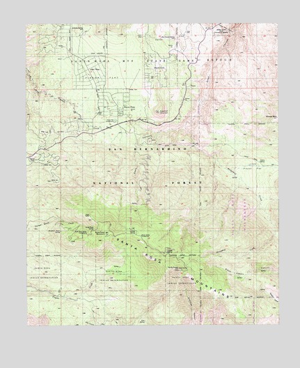
Toro Peak, CA USGS Topographic Map
Click on map above to begin viewing in our Map Viewer.

This topographic map contains these locations and features:
Feature Name Type Latitude Longitude GNIS ID View Map
Alpine VillagePopulated PlaceN33.6061°W116.4697°1667712View Map
Asbestos MineMineN33.6100°W116.4825°238788View Map
Asbestos SpringSpringN33.6230°W116.4723°238790View Map
Big Horn OverlookLocaleN33.5850°W116.4272°274957View Map
Cactus SpringSpringN33.5676°W116.3852°239975View Map
Cedar SpringSpringN33.5361°W116.4417°240389View Map
Dolomite MineMineN33.5761°W116.4392°241539View Map
Dos Palmas SpringSpringN33.6184°W116.4247°254040View Map
Garnet Queen MineMineN33.5448°W116.4870°242629View Map
Hidden Palm CanyonValleyN33.6209°W116.3970°243420View Map
Hidden Palms State Ecological ReserveParkN33.6234°W116.4036°1667765View Map
Horsethief CreekStreamN33.5828°W116.4211°243674View Map
Little Pinyon FlatFlatN33.5689°W116.3861°244944View Map
Mountain Home SpringSpringN33.5391°W116.4837°246292View Map
Pinyon CrestPopulated PlaceN33.6086°W116.4372°1661233View Map
Pinyon FlatFlatN33.6034°W116.4558°254152View Map
Pinyon Flat CampgroundLocaleN33.5853°W116.4550°247548View Map
Pinyon PinesPopulated PlaceN33.5895°W116.4528°1661107View Map
RibbonwoodPopulated PlaceN33.5703°W116.4989°1661307View Map
Riverside County Fire Department Station 30 PinyonBuildingN33.5852°W116.4480°2664953View Map
Santa Rosa CampgroundLocaleN33.5417°W116.4667°274964View Map
Santa Rosa MountainSummitN33.5378°W116.4614°1661405View Map
Santa Rosa SpringSpringN33.5401°W116.4673°249121View Map
Santa Rosa Spring CampgroundLocaleN33.5381°W116.4711°1667801View Map
Sheep MountainSummitN33.5859°W116.3761°249373View Map
Spring CrestSummitN33.5689°W116.4961°1667805View Map
Stump SpringSpringN33.5391°W116.4497°249998View Map
Stump Spring CampgroundLocaleN33.5370°W116.4442°1667808View Map
TaylorPopulated PlaceN33.5984°W116.4183°252995View Map
Toro PeakSummitN33.5234°W116.4256°250548View Map
Toro SpringSpringN33.5016°W116.4425°1667812View Map
Virgin SpringSpringN33.5302°W116.4312°251083View Map

Note: Coordinates in the location and feature list above are referenced to NAD83 datum.


Copyright (C) 2008-2024 Ryan Niemi / Sunset Dynamics ... All Rights Reserved