TopoQuest Logo
Do you find TopoQuest useful?
Help keep TopoQuest running and adding new maps/features by donating!
Bitcoin:  19c7KJd3qBynnjoSw5npx9KScwjBe4ifkT
Litecoin:  LXs6TkuXGGXo1vDsWCkWVdjQX94eUKd6ui
Home View Maps Find Maps Find Places Resources & Links


Toston, Montana Topographic Map

USGS Map Title: Toston, MT
USGS Map MRC: 46111B4
DRG (GeoTIFF) Download: o46111b4.tif


Neighboring USGS Topographic Map Quads:


  Townsend, MT  
46111C5
 

  Holker, MT  
46111C4
 

  Lippert Gulch, MT  
46111C3
 

  Parker, MT  
46111B5
 

  Toston, MT  
46111B4
 

  Deer Park, MT  
46111B3
 

  Plunket Lake, MT  
46111A5
 

  Lombard, MT  
46111A4
 

  Roy Gulch, MT  
46111A3


Map MRC Location:

N47°
W112°
N47°
W111°
H8 H7 H6 H5 H4 H3 H2 H1
G8 G7 G6 G5 G4 G3 G2 G1
F8 F7 F6 F5 F4 F3 F2 F1
E8 E7 E6 E5 E4 E3 E2 E1
D8 D7 D6 D5 D4 D3 D2 D1
C8 C7 C6 C5 C4 C3 C2 C1
B8 B7 B6 B5 B4 B3 B2 B1
A8 A7 A6 A5 A4 A3 A2 A1
N46°
W112°
N46°
W111°

Toston, MT USGS 1:24K Topographic Map Preview:
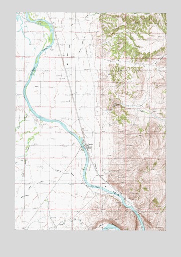
Toston, MT USGS Topographic Map
Click on map above to begin viewing in our Map Viewer.

This topographic map contains these locations and features:
Feature Name Type Latitude Longitude GNIS ID View Map
04N02E04AB__01 WellWellN46.1358°W111.4811°814163View Map
04N02E04BC__01 WellWellN46.1322°W111.4916°814139View Map
05N02E02BB__01 WellWellN46.2230°W111.4489°814658View Map
05N02E02CB__01 WellWellN46.2158°W111.4489°814623View Map
05N02E03AC__01 WellWellN46.2194°W111.4594°814640View Map
05N02E03ACDC01 WellWellN46.2174°W111.4589°814630View Map
05N02E03DA__01 WellWellN46.2158°W111.4541°814624View Map
05N02E03DA__02 WellWellN46.2158°W111.4541°814625View Map
05N02E04DB__01 WellWellN46.2158°W111.4802°814626View Map
05N02E04DBDA01 WellWellN46.2149°W111.4780°814621View Map
05N02E09CA__01 WellWellN46.2010°W111.4855°814557View Map
05N02E10AD__01 WellWellN46.2047°W111.4541°814576View Map
05N02E10ADDD01 WellWellN46.2033°W111.4514°814570View Map
05N02E10CBCC01 WellWellN46.1994°W111.4719°814547View Map
05N02E10DA__01 WellWellN46.2010°W111.4541°814556View Map
05N02E11BC__01 WellWellN46.2047°W111.4489°814575View Map
05N02E14DD__01 WellWellN46.1830°W111.4330°814460View Map
05N02E15AC__01 WellWellN46.1902°W111.4594°814498View Map
05N02E15DA__01 WellWellN46.1866°W111.4541°814477View Map
05N02E15DA__02 WellWellN46.1866°W111.4541°814478View Map
05N02E15DA__03 WellWellN46.1866°W111.4541°814479View Map
05N02E15DACB01 WellWellN46.1852°W111.4552°814471View Map
05N02E16DB__01 WellWellN46.1866°W111.4802°814480View Map
05N02E21AD__01 WellWellN46.1755°W111.4750°814411View Map
05N02E21BC__01 WellWellN46.1755°W111.4908°814413View Map
05N02E21BD__01 WellWellN46.1755°W111.4855°814412View Map
05N02E21DA__01 WellWellN46.1719°W111.4750°814384View Map
05N02E22AD__01 WellWellN46.1755°W111.4541°814409View Map
05N02E22BB__01 WellWellN46.1791°W111.4700°814438View Map
05N02E22BD__01 WellWellN46.1755°W111.4647°814410View Map
05N02E22CBBA01 WellWellN46.1733°W111.4705°814392View Map
05N02E22DB__01 WellWellN46.1719°W111.4594°814383View Map
05N02E23BBDA01 WellWellN46.1785°W111.4469°814431View Map
05N02E23BD__01 WellWellN46.1755°W111.4436°814408View Map
05N02E23CA__01 WellWellN46.1719°W111.4436°814376View Map
05N02E23CA__02 WellWellN46.1719°W111.4436°814377View Map
05N02E23CA__03 WellWellN46.1719°W111.4436°814378View Map
05N02E23CA__04 WellWellN46.1719°W111.4436°814379View Map
05N02E23CA__05 WellWellN46.1719°W111.4436°814380View Map
05N02E23CA__06 WellWellN46.1719°W111.4436°814381View Map
05N02E23CB__01 WellWellN46.1719°W111.4489°814382View Map
05N02E23DB__01 WellWellN46.1719°W111.4383°814375View Map
05N02E23DBBB01 WellWellN46.1735°W111.4397°814394View Map
05N02E23DBCA01 WellWellN46.1716°W111.4389°814368View Map
05N02E23DC__01 WellWellN46.1683°W111.4383°814359View Map
05N02E23DC__02 WellWellN46.1683°W111.4383°814360View Map
05N02E23DC__03 WellWellN46.1683°W111.4383°814361View Map
05N02E26AC__01 WellWellN46.1610°W111.4383°814308View Map
05N02E26BD__01 WellWellN46.1610°W111.4436°814309View Map
05N02E26CA__01 WellWellN46.1574°W111.4436°814294View Map
05N02E26CA__02 WellWellN46.1574°W111.4436°814295View Map
05N02E26CA__03 WellWellN46.1574°W111.4436°814296View Map
05N02E27AD__01 WellWellN46.1610°W111.4541°814310View Map
05N02E27ADDA01 WellWellN46.1602°W111.4519°814302View Map
05N02E27BB__01 WellWellN46.1647°W111.4700°814331View Map
05N02E27BB__02 WellWellN46.1647°W111.4700°814332View Map
05N02E27BB__03 WellWellN46.1647°W111.4700°814333View Map
05N02E27BB__04 WellWellN46.1647°W111.4700°814334View Map
05N02E27BC__01 WellWellN46.1610°W111.4700°814311View Map
05N02E27CC__01 WellWellN46.1538°W111.4700°814274View Map
05N02E27DD__01 WellWellN46.1538°W111.4541°814273View Map
05N02E28ACDA01 WellWellN46.1605°W111.4780°814303View Map
05N02E28AD__01 WellWellN46.1610°W111.4750°814312View Map
05N02E28BBCC01 WellWellN46.1630°W111.4916°814324View Map
05N02E28CD__01 WellWellN46.1538°W111.4855°814275View Map
05N02E28CDDD01 WellWellN46.1519°W111.4836°814264View Map
05N02E29DD__01 WellWellN46.1538°W111.4961°814276View Map
05N02E32AA__01 WellWellN46.1499°W111.4961°814258View Map
05N02E32DAAD01 WellWellN46.1427°W111.4933°814206View Map
05N02E32DD__01 WellWellN46.1391°W111.4961°814185View Map
05N02E32DD__02 WellWellN46.1391°W111.4961°814186View Map
05N02E33AA__01 WellWellN46.1499°W111.4750°814254View Map
05N02E33AB__01 WellWellN46.1499°W111.4802°814255View Map
05N02E33AC__01 WellWellN46.1463°W111.4802°814232View Map
05N02E33BB__01 WellWellN46.1499°W111.4908°814256View Map
05N02E33BB__02 WellWellN46.1499°W111.4908°814257View Map
05N02E33CB__01 WellWellN46.1427°W111.4908°814205View Map
05N02E33DACA01 WellWellN46.1419°W111.4755°814203View Map
05N02E34AADD01 WellWellN46.1485°W111.4516°814246View Map
05N02E34BA__01 WellWellN46.1499°W111.4647°814253View Map
05N02E35BA__01 WellWellN46.1499°W111.4436°814252View Map
05N02E35DAB_01 WellWellN46.1430°W111.4333°814212View Map
05N03E06AA__01 WellWellN46.2224°W111.3905°814655View Map
06N02E26CB__01 WellWellN46.2444°W111.4491°814756View Map
06N02E26CBBB01 WellWellN46.2458°W111.4511°814765View Map
06N02E27BDCB01 WellWellN46.2472°W111.4664°814775View Map
06N02E27CC__01 WellWellN46.2408°W111.4702°814742View Map
06N02E34AD__01 WellWellN46.2333°W111.4544°814708View Map
06N02E34AD__02 WellWellN46.2333°W111.4544°814709View Map
06N02E34BDBB01 WellWellN46.2349°W111.4661°814715View Map
06N02E34CA__01 WellWellN46.2297°W111.4650°814693View Map
06N02E34CA__02 WellWellN46.2297°W111.4650°814694View Map
06N02E34CD__01 WellWellN46.2260°W111.4650°814677View Map
06N02E34DC__01 WellWellN46.2260°W111.4597°814676View Map
06N02E34DD__01 WellWellN46.2260°W111.4544°814675View Map
Big Springs DitchCanalN46.1827°W111.4475°806161View Map
BrewerPopulated PlaceN46.1380°W111.4008°769203View Map
Broadwater - Missouri CanalCanalN46.2024°W111.4436°777716View Map
Crow CreekStreamN46.1935°W111.4877°781925View Map
Devils BottomBendN46.1288°W111.4233°770616View Map
Devils Bottom MineMineN46.1266°W111.4280°802589View Map
Dry CreekStreamN46.2419°W111.4694°782578View Map
Dry HollowValleyN46.2219°W111.4305°782649View Map
Lombard CanalCanalN46.1441°W111.4727°773569View Map
Marsh CreekStreamN46.1641°W111.4936°776951View Map
Methodist-Episcopal ChurchChurchN46.1727°W111.4411°1762240View Map
Missouri River BridgeBridgeN46.1719°W111.4439°1762271View Map
Missouri River Grain Company ElevatorLocaleN46.1727°W111.4411°1762244View Map
Sixmile CreekStreamN46.1844°W111.4575°790560View Map
The Church of Jesus Christ of Latter Day SaintsChurchN46.1727°W111.4411°1762239View Map
TostonPopulated PlaceN46.1727°W111.4411°777714View Map
TostonLocaleN46.1727°W111.4411°1762201View Map
Toston Catholic ChurchChurchN46.1727°W111.4411°1762242View Map
Toston Census Designated PlaceCensusN46.1658°W111.4460°2409341View Map
Toston Fishing Access SiteLocaleN46.1705°W111.4444°1744449View Map
Toston Methodist ChurchChurchN46.1727°W111.4411°1762241View Map
Toston MineMineN46.1560°W111.4208°802592View Map
Toston Post OfficePost OfficeN46.1724°W111.4410°1762248View Map
Toston Post Office (historical)Post OfficeN46.2013°W111.4558°1762159View Map
Toston School (historical)SchoolN46.1708°W111.4400°1762192View Map
Toston TunnelTunnelN46.1266°W111.4422°777718View Map
Toston Volunteer Fire DepartmentBuildingN46.1711°W111.4484°2546650View Map
Warm Springs CreekStreamN46.1680°W111.4919°778114View Map

Note: Coordinates in the location and feature list above are referenced to NAD83 datum.


Copyright (C) 2008-2024 Ryan Niemi / Sunset Dynamics ... All Rights Reserved